You don’t have to be Santa to climb this chimney
Published 4:00 am Thursday, December 11, 2008
- Now is a great time to take the hike to Chimney Rock because the trail is dry, cool and lacking snow. From the top of the cliffs, hikers can see views of the river below surrounded by high cliffs, the expanse of High Desert and the Cascades in the far distance.
In the days just following Thanksgiving, after too much food and too much sitting around, I felt a deep desire to get out. I needed to work out and to breathe fresh air.
And in the late fall, I knew the High Desert was a great place to do just that. The area east of Bend is sunny, with crisp air, but no snow or soggy trails.
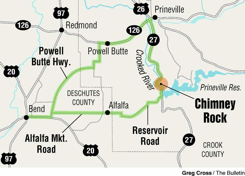
With my father and sister-in-law along, I headed east to a hike I had done in the past. Chimney Rock sits just north of Prineville Reservoir on the Crooked River about 15 miles south of Prineville.
The drive to get there is part of the fun. We cut through Alfalfa and kept heading straight east to the reservoir. Heading through oceans of low-slung sagebrush and juniper, my sister-in-law pointed out that the muted colors were calming. They softly balanced the intensely bright blue sky.
Just before we arrived at the reservoir, we turned north on state Highway 27 and followed the twisting road down into the canyon along the river. The canyon walls are an impressive array of jagged rocks and outcroppings, with each bend revealing a new towering shape.
Chimney Rock sits atop these walls at the point where the river makes a giant bend. From the road, the rock looks like a large thimble resting on top of a hill.
We followed a well-maintained trail out of a small parking lot. Most of the climb was fairly vertical, although not overly strenuous. It felt like enough of an effort to help melt away some of the pumpkin cheesecake I consumed.
The walk to Chimney Rock offered incredible views. Each turn along the trail showcased a slightly different angle from which to admire the hills, twisting river and Cascades in the far distance.
Up close, the trail sports interesting rocks and plants. My father, a lifelong Oregonian and nature buff, enjoyed pointing out sage and mistletoe clinging to some juniper branches. He makes an ideal hiking guide because he knows not only the names of plants and trees, but also the history of Oregon and its geology.
He pointed to some gray rocks underfoot that had been rounded by trickles of water. Clearly a stream or river had run down the trail at some point. This was my third time on this hike and I had never noticed the washed rocks before.
For my sister-in-law, a New Jersey-native who grew up hiking the Catskills, the terrain was completely new. She picked up small rocks and examined their intricacies. She snapped pictures of bright green lichen growing on trees and shrubs I would otherwise pay no mind to. Hiking with different companions, with such different views and experience, allowed me to see the freshness and the richness around me.
The trail wound along the side of a bluff and ultimately emerged on the top of a butte. Just as the trail became easier and my huffing subsided, we took a break on a little bench. The views from this spot offered a great payoff. The rolling hills, vast cliffs and sparse greenery showcased this lovely desert vista.
Growing up in Western Oregon, it always feels fantastically strange to be so close to home, yet surrounded by desert.
Past the bench, the trail meandered along the top of the bluff. Then, we turned a corner and caught glimpse of Chimney Rock. Even up close, it resembled a thimble or overturned cup. Perhaps not the most impressive landmark, but it was pretty cool nonetheless.
A second bench located right at the base of the rock offered a perfect location to snap pictures and sip water.
And because we had turned the corner, this spot offered completely different views, but equally spectacular.
The descent back down went quickly.
We hiked for about 90 minutes in all. Back at the car, we decided not to go back the way we came. Instead, we headed north to Prineville. Once there, we rewarded our efforts with ice cream at the Tastee Treet. I got black licorice, the darkest, craziest ice cream I had ever seen or eaten.
On the drive back to Bend, we all felt a bit tired as the workout coupled with ice cream did its job. We listened to music and watched as the sun dipped behind the mountain peaks.
We felt sleepy, but, at least this time, it wasn’t from the turkey.
If you go
• From Bend, head east on U.S. Highway 20, turn left on Powell Butte Road, turn right onto Alfalfa Market Road for about 9.5 miles and continue straight as the road turns into Willard and then Reservoir Road for about 13.6 miles. Turn left onto state Highway 27, also known as the Lower Crooked River Back Country Byway. The trailhead is after milemarker 15 on the right-hand side, across from the Chimney Rock Recreation Area.
• From Prineville, head south on Main Street, which turns into state Highway 27, for about 16 miles. The parking area is on the left-hand side, across from the Chimney Rock Recreation Area.
Difficulty: Moderate; hike is 2.6 miles round trip.
Contact: Bureau of Land Management Prineville District 541-416-6700.
More Local News


Best of the Best of Bend 2025

-
-
-