Crook County plans emergency route for Juniper Canyon
Published 4:00 am Sunday, March 26, 2006
- Crook County plans emergency route for Juniper Canyon
To get to Sue Berdine’s house in the Juniper Canyon area south of Prineville, there is only one way in and out.
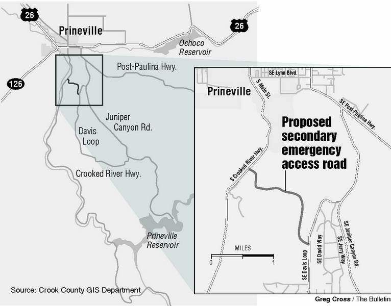
Berdine’s house is off Juniper Canyon Road – an 18-mile cul-de-sac that winds from the south end of town to the Prineville Reservoir. To leave her rural subdivision, Berdine must take Juniper Canyon Road north to the Paulina Highway intersection.
Trending
Most days, it’s not a problem.
But if an emergency struck and Berdine and her more than 3,000 neighbors in Juniper Canyon had to evacuate, she worries they would hit a bottleneck as they tried to make it to the intersection.
Seeing the growth that has sprouted in Juniper Canyon, Crook County officials are planning to create a roughly five-mile graveled road for emergency access.
The road would jut off from lower Davis Loop at the northeast end of Juniper Canyon Road for about two miles and hook into the Crooked River Highway. Once they reach the Crooked River Highway, it would take drivers about five to 10 minutes to reach downtown Prineville.
Crook County Judge Scott Cooper said initially the road would only serve as a ”backdoor” route in case of emergencies and would not be open to the public, he said.
As development occurs, the county expects to ask developers to help foot the bill to pave the road and make it a permanent public byway, he said.
Trending
The county hopes to start building the new road as soon as possible, and it’s expected to cost about $700,000 to add gravel along an old military route, he said.
Berdine said she thinks it would be money foolishly spent because the secondary road would not open up the bottleneck, especially for the thousands of people who live closer to the Prineville Reservoir.
”The secondary access wouldn’t be a solution,” Berdine said. ”If we all try to get out on Davis Loop, it’s not going to happen.”
The secondary road does not solve the other problems with Juniper Canyon Road either, she said.
When the weather turns cold, the thruway to the reservoir ices over, leaving the rural residents at risk or stranded, she said.
During the summer, when traffic heats up with cars heading to and from the reservoir, many Juniper Canyon residents have to dodge speeding drivers who suddenly appear over the hills, she said.
The best place to put a second road, Berdine said, is further south on Juniper Canyon Road, closer to the reservoir where it could connect to the Paulina Highway.
Cooper, the county judge, said the county had few route choices for a new road because the dirt tracks either couldn’t be navigated or cut through environmentally sensitive areas.
Sgt. Russ Wright with the Crook County Sheriff’s Office, who is the county emergency planner, said Juniper Canyon access is becoming a big concern as the population grows.
Juniper Canyon has already mushroomed from a modest spot for people with second homes and mobile homes to an increasingly upscale attraction for retirees and people who want elbow room.
For instance, Bend developers are currently turning a 1,975-acre parcel in the Juniper Canyon area into a 313-lot subdivision with properties ranging in size from five to 18 acres. The first round of bare lots in the six-phase subdivision fetched $129,000 to $179,000.
Wright said wildfires pose the biggest threat in Juniper Canyon, and if an emergency broke out, it would take hours to evacuate the area.
Right now, there is a makeshift road that leads from the north shore of the reservoir to the Paulina Highway that could be used for evacuations, Wright said. But there should be another road from upper Davis Loop that connects to the Paulina Highway.
”(Juniper Canyon) is like a dead-end road,” Wright said. ”The secondary road will be better than nothing but it’s not going to solve the problem.”
Marketplace


Enter the $5,000 Sweepstakes

-
eEdition

-

-