A visit to blue lagoon
Published 5:00 am Wednesday, June 28, 2006
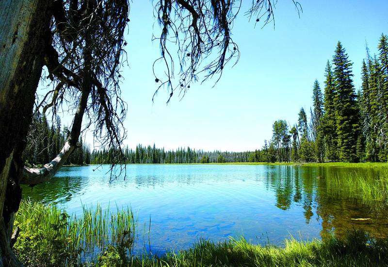
- Blue Lagoon is just downstream from Little Lava Lake. Just below, the banks narrow and the river flows faster.
When it goes from cool to mop-your-brow scorching virtually overnight, ravenous mosquitoes don’t seem so bad. You pull out the insect repellent and deal with it.
The upper section of the Deschutes River not far from the headwaters is usually several degrees cooler than Bend or Redmond. The tall pines offer shade and the river is cold, clear and inviting, even if you just sit on the bank and soak in the sylvan charm of the midelevation Cascades.
Trending
While the high country is melting out slowly after a big snowfall winter, there are plenty of spots along Cascade Lakes Highway that are finally accessible and offer that classic mountain setting without the need to posthole across pesky patches of snow to get where you’re going.
You might not be able to hike up from the Green Lakes trailhead quite yet without hitting snow, but you can get to the Upper Deschutes. About a half-mile south of the turnoff to Lava Lake is an inconspicuous little trailhead on the left that leads out to the Upper Deschutes and a place called Blue Lagoon. As the name implies, Blue Lagoon is a little-known oasis within striking distance of town. It’s about a half-mile hike to the river, where the banks widen, forming a large pool. It looks trouty in a high mountain, small stream sort of way, and if you plan your visit during the work week, you just may have the place to yourself.
Continue south another 3/4 mile or so on Cascade Lakes Highway and you come to Mile Camp on the left. Turn in and drive to the day-use area on the river. There are tables for a waterfront picnic and a rough trail that runs up and downstream. Last week, downed trees still crisscrossed the trail like lattice work, but our effort was rewarded with a better view around every turn and twist.
The Deschutes River up here is remarkably different from the river that slides by Bend, which in turn is a far cry from the Deschutes that builds a significant head of steam below the dams near Warm Springs. There’s a valid reason that The Bulletin’s in-house style guide differentiates between the Upper, Middle and Lower Deschutes along its 252-mile run from near Lava Lake to the Columbia River. The Upper Deschutes runs to the city of Bend, where it’s dammed and irrigation water is pulled out during the summer months. The Middle Deschutes, noted for low summer flows, begins in Bend and ends at the Pelton-Round Butte Dam complex. After Lake Billy Chinook and Lake Simtustus, the Lower Deschutes changes character again, becoming a classic big Western river known for its healthy rainbow trout and steelhead sports fishery.
Up here, at Mile Camp, the Deschutes is a mountain stream with riffles and runs and water you can see right through.
It’s a pleasant place for a short hike, a bit of fly fishing or a family picnic. But those snow-melt mosquitoes will eat you up if you don’t go prepared.
Trending
It’s a small price to pay for an afternoon of blissed-out mountain solitude.
If You Go
Getting there: From Bend, drive west on state Highway 46 (Cascade Lakes Highway). The Blue Lagoon trailhead and Mile Camp are on the left, about 1/2 mile and 1 1/4 miles past the Lava Lake turnoff, respectively.
Contact: The Bend-Fort Rock Ranger District of the Deschutes National Forest at 383-4000.
Marketplace


Enter the $5,000 Sweepstakes

-
eEdition

-

-