Trail to Flatiron Rock
Published 5:00 am Wednesday, May 23, 2007
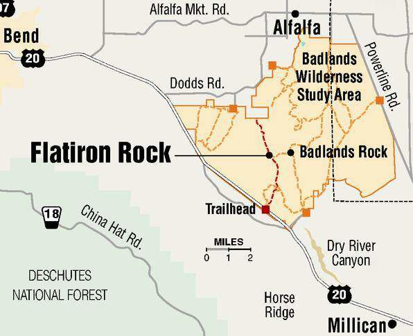
- Trail to Flatiron Rock
I finally figured out why I like hiking in the Badlands so much.
More than any mixed conifer forest, any sylvan glade or snow-capped peak, the Badlands Wilderness Study Area is a microcosm of this sprawling, rough-edged, big-hearted region we live in.
The West. Its a land of contradictions. It appears flat until you notice the contours. It looks empty until you start seeing all the life. It can be sizzling hot or bitter cold.
Bulletin colleague Andrew Moore pointed out the thing that strikes you when youre out in the midst of all that. Theres a lot of land out here.
We were enjoying a day out on the Badlands, hiking to Flatiron Rock. The Badlands is about 37,000 acres of burnt brownie lava flows, rabbitbrush and gnarly old junipers. Its dry and dusty, and once you trek in a ways, the landmark ridges disappear from view and youre left with a cloistered view of things.
The Badlands is small compared to many potential wilderness areas. Its a little piece of wild land on the edge of something so vast that it can be difficult to comprehend. But the concept of the West (and all that topography) is approachable if you break it down, take it five or six miles at a time. And remain open to what you see and experience along the way.
Some things are obvious. We saw a dust devil pick up steam, touch down in a series of little whirling eruptions, and race out over the High Desert toward us only to dissipate before either of us could pluck a camera out of the pack and focus. And, not long after we discussed the conspicuous absence of pronghorn in the area, a pair of speed goats trotted by (again, we botched the camera thing).
Some things are more subtle.
Flatiron Rock is a big jumble of volcanic boulders about three miles from the trailhead. From the base, youd never know there are open trails up top that lead past clumps of Great Basin ryegrass, little caves, portals and other items of biological and geological interest. Climb atop the rock and you have a 360-degree view of the surrounding countryside, including the entire Cascades array.
In late 2005, Bureau of Land Management officials completely closed the Badlands to motorized vehicles. For years, environmentalists have campaigned to include the area just east of Bend in the National Wilderness Preservation System. The BLM recommended the Badlands for wilderness consideration in 1990; approval is contingent upon congressional action.
The result is a hiking experience, close to town, that feels as if youve traveled far and wide.
Hiking back toward the trailhead and car, we marveled at the tenacity of the wildflowers: delicate purple, blue and yellow blooms all enjoying their day in the sun. Everywhere, the sandy soil is dusty and dry; how do they survive?
Friday was a warm one. Henry the dog sprinted from shady spot to shady spot, sprawling briefly at each before resuming his journey. We found ourselves discussing the laid back magnificence of these open spaces and the enormity of the Western sector of the United States. The conversation took us from the dry rolling landscape between Burns and Boise to the bizarre hoodoo beauty of the Four Corners country in the Southwest and back again to this corner of a remarkable region.
We rounded a bend in the trail, the highway came into view and the hike was over. With a slam of the car door, the wide open West was just a state of mind once again.
More Local News


Best of the Best of Bend 2025

-
-
-