Central Oregon butte-ies
Published 5:00 am Wednesday, March 19, 2008
- Central Oregon butte-ies
Central Oregonians are used to buttes.
There are black ones and gray ones, round ones, square ones and many that are named after prominent pioneers.
These “steep hills standing alone in a plain” — as Webster’s New World Dictionary describes them — are as much a part of this High Desert landscape as juniper, sagebrush and ponderosa pine.
We might have a tendency to take them for granted, to pass them off for the lofty peaks to the west. That would be a mistake (Mount Bachelor, I’m reminded, is a lofty butte).
According to www.geology.com, a butte is “a conspicuous hill with steep sides and a flat top. The top is usually a cap rock of resistant material. This structure is frequently an erosional remnant in an area of flat-lying sedimentary rocks.”
In Central Oregon, buttes are reminders of our volcanic underpinnings.
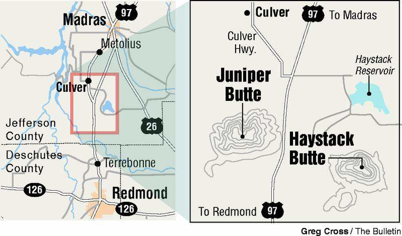
There are two imposing buttes north of Terrebonne that we all pass by while driving on U.S. Highway 97. Heading north, Juniper Butte is on the left and Haystack Butte is to the right. If you see the ODOT weigh stations, you can probably see both buttes.
Both have recreational significance.
Juniper Butte, all 3,925-feet elevation and sprawling, rocky top, juniper flanked bit of it, is part of the 155,000-acre Crooked River National Grassland. The run-up to Haystack Butte from the west is inside the federally administered grassland; part of the butte itself is privately held.
You can drive close to the base of Juniper Butte and explore the folds and creases of the butte. The higher you go, the better the view of the snow-mantled Cascades to the west.
Last week, my dog Hoss and I opted to poke around the plains and hills on the other side of the highway. A couple of miles past the Juniper Butte turnoff, we swung right on the road that cuts back south, parallel to the highway, then left (east) on a gravel road marked by a large pile of cinder. Be sure to admire the red-rock formations to the left where the road jogs to the northeast. That’s Haystack Butte on the right. I pulled off the road so Hoss could scare up a jackrabbit or two and I could stretch my legs. We hiked about three-quarters of a mile up a gradual incline of sagebrush and an occasional juniper tree before coming to a barbed-wire fence. I could hear, but couldn’t see, cows bawling on the other side. Although Hoss made a couple of darting forays onto the private property, I didn’t. The inholdings here (and everywhere) are to be respected. Maps are available through the Crooked River National Grassland office in Madras. Contact them at 475-9272.
While we couldn’t access the butte from this side, we had a close-up view of the base of the butte, the forested hillside and the top (I wonder what it looks like up there). I spent a while imagining the country unseen, then looked back over the grassland toward the car and slipped into another reverie.
Back in the 1920s and ’30s, farmers who had homesteaded this marginal ground and found it a tough row to hoe, began packing up and heading out. Farm prices had plunged and drought followed floods. For many, it was a struggle to pay taxes and mortgages. In the 1930s, the federal government bought back homesteads that had fallen on bad times, according to former Grassland District Ranger Kristin Bail. Some of those lands became the Crooked River National Grassland.
This wide open country hasn’t changed much, if at all, since those difficult days.
Walking back toward the road, the wind kicked up and a hard snow began peppering everything in its path, including my exposed face and sunglasses. In reality, it wasn’t snow, exactly, and it wasn’t hail. It was those little, solid white pellets that defy definition, except probably among Eskimos. Anyway, it was hard to see for a spell there, and I thought of great clouds of locusts and how much pluck it must have taken to try and wring a living from this land.
The snow and the gray pall moved on to the east and the sun shone bright. Hoss surprised a rabbit and bounded off in pursuit. An old pickup bounced by on the road. Back up on the butte, at 4,015 feet, the storm was picking up steam.
If you go
• To reach Juniper Butte from the northern city limits of Terrebonne, drive seven miles north on U.S. Highway 97 and turn left onto the gravel road. Watch for a pullout and gate on the right. The butte is also on the right.
• The turnoff to the Haystack Butte area is nine miles north of Terrebonne, on the right. Look for the cinder pile one-half mile up the road on the left. Turn left. The road leads to Haystack Reservoir, with the butte to the east.
Contact: For maps or information, Crooked River National Grassland, 475-9272.
More Local News


Best of the Best of Bend 2025

-
-
-