Whychus Creek
Published 5:00 am Friday, June 27, 2008
- Whychus Creek
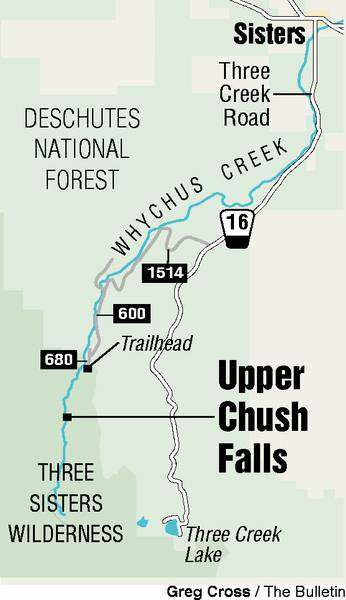
Upper Chush Falls, formerly Squaw Creek Falls, is a perfect hike for those times when you feel like getting your gratification quickly. Not instantly, but at three-quarters of a mile from the trailhead, you’re knocking on the door before you break much of a sweat.
Even so, if you count the drive in, Upper Chush Falls makes for a nice half-day outing.
Trending
Soon after turning west off the main road seven miles south of Sisters, you see North, Middle and South Sister loom into view; it’s a stunning sight and worth the drive even if you never set boot to trail.
The last couple of miles to the trailhead are rocky and rough and the going is slow. But once you’re parked and striding out, the payback is sweet.
The trail ascends moderately from 4,800 feet to 5,200 feet. There’s a pair of steep sections, but they don’t last long. Just focus on the pine and fir and the way the sunlight dapples the forest duff and you probably won’t even notice the burn.
Three-quarters of a mile in, there’s an unimproved overlook from which you can admire the grandeur of these spectacular falls. There’s a whole lot of serious hydraulics at work here.
The Cascades, another falls, is about one-half mile beyond the overlook. The trail peters out, but if hikers keep the creek in sight, they can travel cross country and extend the outing.
According to the Forest Service, the water flowing over these falls begins as snow and glacial ice on Broken Top and South Sister. Sometimes Whychus Creek carries a red tinge from eroded volcanic cinders. This time of year, the creek is a milky gray. That’s from “glacial flour,” particles of rock ground by glacial action and deposited in the stream.
Trending
At the trailhead, be sure to take the time to fill out a free wilderness permit, which is required for travel in the Three Sisters Wilderness. It might seem like a hassle for such a short hike, but there’s a good reason the Forest Service prints them up and maintains a drop box in which to collect them.
If you get lost or injured in the backcountry, rescue workers can consult the permit and gain valuable information such as where you were headed and the number of people in your party. In addition, if someone else gets lost or fractures a fibula, emergency personnel will know who’s out there and who may have seen the hiker for whom they’re searching.
Whenever you’re planning a summer season wilderness adventure, it pays to pack a map, compass, flashlight, extra food, extra clothes, sunglasses, a first aid kit, pocket knife, waterproof matches, a fire starter and water.
From Sisters, take Road 16 (Elm Street) south for seven miles. Turn right on Road 1514 and continue 4.8 miles to Road 600. Turn left and follow Road 600 for two miles, then turn left on Road 680. The trailhead is about one-quarter mile down the road. Take it slow; these roads are rough.
A Northwest Forest Pass is required to park at the trailhead.
— Jim Witty
Marketplace


Best of the Best of Bend 2025

-
eEdition

-

-