River guide helps paddlers navigate the Deschutes
Published 5:00 am Thursday, July 31, 2008
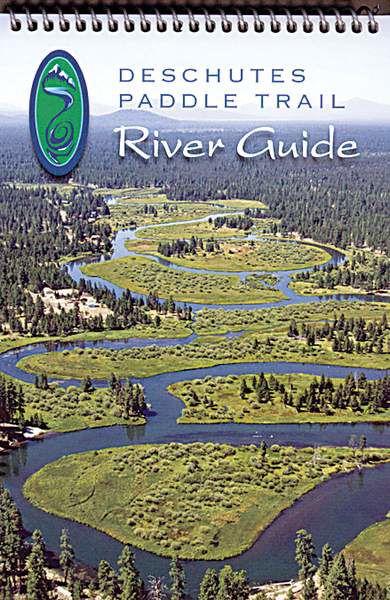
- River guide helps paddlers navigate the Deschutes
The Deschutes Paddle Trail includes the navigable sections of the Deschutes River and Little Deschutes River as well as nine of the largest Cascades lakes in Deschutes County.
The Bend Paddle Trail Alliance has published the “Deschutes Paddle Trail River Guide” and a separate (free) fold-out guide for the region’s lakes.
Trending
The river guide is a mile-by-mile look at 26 miles on the Little Deschutes, from La Pine to the river’s junction with the Deschutes River near Sunriver, and 95 miles of the big Deschutes, from Wickiup Reservoir to Lower Bridge, the last take-out in Deschutes County.
According to the alliance, the Paddle Trail contains lots of placid reaches, but also several experts-only and even unrunnable sections.
Because the river is tapped for irrigation, high and low flows are seasonal.
The guide also includes sections on river health, history, plans for the future, water quality and quantity, wildlife, plants, outdoor ethics, paddling safety, river etiquette, resources, organizations and a handy breakdown of river reaches by paddling difficulty.
Signs will eventually be posted at designated areas that are referenced in the river and lakes guides to aid users.
Publication of the guides will be celebrated beginning at 9 a.m. Aug. 16 at Alder Creek Canoe and Kayak in Bend. The celebration will include paddle trips, a briefing, a barbecue and live music.
Trending
The guides were published with funds from a Recreational Trails Program Grant from the Oregon Parks and Recreation Department as well as gifts from businesses and donors.
The “River Guide” retails for $15.
Contact: www.bendpaddle trailalliance.org.
Marketplace


Best of the Best of Bend 2025

-
eEdition

-

-