Looking to future, feds lay plans for energy grid in Oregon
Published 3:16 am Thursday, January 15, 2009
- Looking to future, feds lay plans for energy grid in Oregon
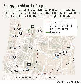
The U.S. Forest Service and Bureau of Land Management have finalized 6,000 miles of future routes for power lines and pipelines across 11 Western states — including a corridor running through southeastern Deschutes County and western Crook County.
The energy corridors are designed to consolidate transmission paths and streamline the permitting process for the projects, federal officials said.
But some conservationists said the decision doesn’t adequately consider endangered species habitat or the transmission needs of renewable energy projects.
Jill Moran, a spokeswoman with the national BLM office, said the designation doesn’t automatically give an OK to developers wanting to put in a project, adding that each project would undergo further environmental review.
“These are just designations,” Moran said. “The agencies have identified their preferred locations for where they would prefer to have future energy projects go through.”
The goal of the corridors, which were called for under the 2005 Energy Policy Act and developed with the BLM and the Department of Energy as lead agencies, is to cut down on piecemeal energy projects across the landscape and instead focus the corridors in certain places, she said.
And the corridors could also allow developers proposing pipelines or transmission lines to only have one set of requirements or regulations, instead of potentially dealing with multiple agencies, Moran said.
The corridors were placed according to where the need is and where the power is coming from, she said. Potential renewable power sites were also considered. But often, the sources of power and the population centers are far apart, she said.
Planners also set the routes based on topography constraints and sensitive environmental areas, Moran said. About 70 percent of the energy corridors outlined in the decision were already identified by states or federal agencies.
The Bureau of Land Management and the Forest Service both approved records of decision Wednesday for the energy corridors, which include 565 miles in Oregon. It has been a three-year process leading up to this point. The next stage, Moran said, would be for developers to propose projects.
In Central Oregon, the proposed transmission corridor would start near Powell Butte in Crook County, then go south to the border with Deschutes County. There, it would split, with one route going southeast, almost paralleling U.S. Highway 20 past Brothers and Hampton, and the other route heading farther south, past Pine Mountain and into Lake County.
Dave Becker, staff attorney for the Bend-based Oregon Natural Desert Association, said environmental concerns were not appropriately addressed during the process, which causes concerns when it goes near places like the Hart Mountain National Antelope Refuge in Southern Oregon.
“They’ve drawn a line on a map without really making an informed decision,” he said.
Corridors in southeastern Oregon go through sage grouse habitat as well as critical pronghorn migration routes, he said, adding that the agencies did not consult with the other federal agencies that manage endangered fish and wildlife. And he said the transmission routes don’t adequately consider where renewable energy projects might go.
Conservation groups recognize the need for new transmission routes, and recognize the need to concentrate them so there’s not a “spaghetti-like effect across the West,” he said. “Lots of people would like to see the new administration take another look at it.”
For more information about the energy corridors, visit corridoreis.anl.gov
More Local News


Best of the Best of Bend 2025

-
-
-