Diamond Craters
Published 4:00 am Friday, January 16, 2009
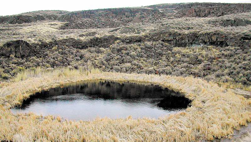
- This water-filled maar is a highlight of Diamond Craters.
Geology happens everywhere. It’s just more evident out here in the southeast Oregon outback where there’s nothing shaggy to get in the way.
Between the micro towns of Crane and Frenchglen, the subtly textured terrain rolls and folds but mostly stretches, its nappy surface right there for all to see. Diamond Craters is an ideal place to study the origins of this landscape and, if you enjoy exploring the mysteries of the High Desert, to stomp around and discover what’s over the next rise.
Which is always more unwavering country as far as the eye can see and, occasionally, just often enough, an encounter with an eagle, a coyote or a wary herd of pronghorn.
Scientists contend there’s no other place on this continent quite like Diamond Craters.
According to a visitor’s guide written by Ellen M. Benedict of Pacific University and produced by the Bureau of Land Management, “It has the best and most diverse basaltic volcanic features in the United States and all within a comparatively small and accessible area.”
Take a 7- or 8-mile drive on a passable dirt road (with as many side trips on foot as you care to make) and digest Benedict’s detailed self-guided text, and you’ve pretty much read the condensed geology of Eastern Oregon as written on the land.
It’s an earth-shattering tale, with incendiary characters and an explosive plot. It’s fairly epic, too.
The rimrock on three sides of the Diamond Craters Outstanding Natural Area originated from a volcanic vent near Burns about 9.2 million years ago. The six main domes here were formed sometime in the last 25,000 years — a second or so in geologic time. When the eruption occurred, lava oozed through deep fissures and flooded a dry lake bed, Benedict writes. Before the first layer cooled, more magma flowed underneath and created the six domes.
On the self-guided tour, you’ll see classic lava flows, small shield volcanoes, pit craters, uplifts, ash flows, calderas, grabens, spires and Big Bomb Crater. The last is the site of a spectacular aerial display 17,000 years ago. To this day, the pit yields marble- to baseball-size “cored bombs,” that shot into the sky during that fateful moment in geologic time (don’t remove anything from the area; you’d be destroying something that’s bigger than all of us).
One of the coolest stops on the tour is Malheur Lake or Maar, a volcanic pond, part of which, from above, looks like the top of a bald head fringed with hair. Park adjacent to Dry Maar, which, according to the brochure, is similar to the larger Hole in the Ground near Fort Rock. Malheur Lake is a 400-foot walk to the north.
Malheur Lake is a 6-foot-deep, spring-fed lake filled with about 50 feet of sediments. The sediments reveal that the crater has contained water for the past 6,000 years. Scientists value this particular maar because it collects pollen, plant debris and tephra (soil) that offers a window to past climates.
“All of this makes Malheur Maar one of the most significant desert lakes between Mexico and Canada,” Benedict writes.
Although most folks’ knowledge of geology runs about as deep as a sandbar, an afternoon spent at the craters will widen it some. And, at 55 miles from a town of any size along with views of snowy Steens Mountain and the Malheur River at most every turn, the isolation provided by Diamond Craters is splendid.
From Bend, drive east on U.S. Highway 20 to Burns. From Burns, drive about 35 miles southeast on State Route 78 to the Diamond Cutoff at Princeton. The heart of the craters country is between Princeton and Diamond. An alternate route is to drive south on State Route 205 from Burns. Turn left at Diamond Junction near milepost 40. Caution: There are no facilities at Diamond Craters. Keep your vehicle on hard-packed surfaces to avoid getting stuck, and stay on the main dirt road through the craters (there are numerous side roads that could pose problems). Carry essential gear and plenty of water.
Watch out for rattlesnakes during the warm months. For a self-guided tour brochure, stop in the store at Riley on the way from Bend to Burns. There’s also a bulletin board with pertinent information at Diamond Craters.
Permits: None needed. Contact: Bureau of Land Management, Burns District, 541-573-4400.
— Bulletin staff
More Local News


Best of the Best of Bend 2025

-
-
-