Let nature be your guide
Published 5:00 am Sunday, July 26, 2009
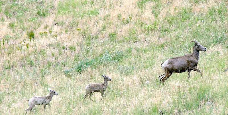
- Two spring lambs follow a bighorn sheep ewe through the grasslands of the Imnaha River drainage in the Hells Canyon National Recreation Area near Dug Bar.
JOSEPH — My trip through Hells Canyon of the Snake River began in the shadow of the dramatically beautiful Wallowa Mountains, in the northeastern corner of Oregon.
It ended at Dug Bar, on the floor of the canyon, at the point where Chief Joseph led his tribe across the flooding Snake into Idaho at the start of the Nez Perce War in 1877.
Trending
In between, for four days, eight other travelers and I voyaged 51 miles through one of the deepest gorges on the North American continent. We braved huge whitewater rapids, a dramatic thunderstorm, rattlesnakes and wild animals — yet we were rewarded with spectacular scenery, glimpses of historic log homesteads and ancient Indian petroglyphs, and a heaping helping of camaraderie.
Among our group, which ranged in age from 27 to 78, were three guides from the Joseph-based Winding Waters River Expeditions, led by master oarsman Morgan Jenkins. A transplanted Virginian, Jenkins, 40, estimated he’d run Hells Canyon 120 times since he first came west in 1990. This would be number 121.
Our vessels were a pair of large, yellow rubber rafts. Jenkins sat at the heart of the passenger vessel, surrounded by Dennis and Chris Cornwell, a father and son from Houston; David and Betty Darling, a retired couple from Santa Monica; Steve Smith, a computer programmer from Corvallis; and me. River guide Sam Mackey manned the gear boat, assisted by Patrick Wright.
Day 1
After an overnight stay at Chandlers Inn, a delightful bed-and-breakfast lodge on Main Street in Joseph — a Sisters-sized town that is the soul, if not also the heart, of the Wallowa Valley — we piled into a van and drove to Hells Canyon Dam.
This is not an easy drive under any circumstance. Though paved, many of the 51 miles through Wallowa-Whitman National Forest to state Highway 86, near Halfway, are closed for half the year by snow. The winding, mountainous road is especially difficult to negotiate in a van with 10 people (including our driver), pulling a trailer stacked with rafts and gear. The final 38 miles, which follow the Snake down Oregon’s eastern border, pass a series of Idaho Power Co. dams and reservoirs to the put-in point at Hells Canyon Creek Recreation Site.
Trending
At a modest visitor center, a short film introduces the geology and human history of the canyon. I purchased a “Boater’s Guide” and joined the rest of my party at the boat ramp just downriver from the dam. We loaded our vessels and set off.
I am not certain of the assertion that Hells Canyon is the deepest river-carved gorge in North America: 7,913 feet from the high point of Idaho’s adjacent Seven Devils Mountain (9,393 feet) to the canyon floor at Granite Creek (1,480 feet). I do know Hells Canyon is a couple of thousand feet deeper than Arizona’s far-more-colorful Grand Canyon of the Colorado River. (California’s Kings Canyon makes a claim to being deeper, at 8,200 feet.)
On both sides of the northbound Snake, basaltic cliffs rise in steps thousands of feet above the river, most recently gouged by the great Bonneville Flood of about 15,000 years ago. Here and there, gravel bars and alluvial streams have created broad benches where Nez Perce once wintered and pioneer homesteaders built remote cabins and orchards. As recently as 1975, when the Hells Canyon National Recreation Area was established, sheep grazed the sparsely vegetated terrain.
Our first day on the river was short — we covered only about five miles after our long drive — but it was a good introduction to what would follow. At Lamont Springs, just a mile and a half downstream from our put-in, we stopped for lunch sandwiches and were greeted on the beach by the fresh, berry-rich scat of a black bear, a reminder that we were truly in the wilderness. I wondered about the fate of a single small doe grazing beside the river near our stopping point, but I knew the family of four bald eagles, poised together in a nearby ponderosa pine, were not going hungry.
The Snake is a big river. It carries far more water than the Deschutes, the John Day or the Rogue, all popular rafting rivers in Oregon. Its flow is controlled by the trio of dams just upriver of the canyon, but even now, at a moderate 22,000 cubic feet per second, the Snake can be a fearsome playmate. Although on a previous float of Hells Canyon, a dozen years ago, I had paddled the 32 miles from the dam to Pittsburg Landing, I was happy to be making this trip on an oar boat, with a single river expert (Jenkins) taking us through the tough spots.
After our first lunch, we tested the Class II (modest difficulty) rapids at Brush Creek and Rocky Point without a hitch.
Five miles after our launch, we set up camp near Battle Creek, which flows past a small gold mine and an abandoned cabin. I didn’t attempt to explore the mine, which hasn’t been worked in 93 years; but I did walk a couple of hundred yards past an old (and still productive) apricot orchard to the Barton Cabin, by which rusted farm machinery lay in neglect.
Our group set up our tents in a meadow littered with depressions that, our guides explained, had provided foundations for prehistoric pit houses. Covered with a framework of branches and deer or elk hides, these once provided comfortable winter homes on the canyon floor.
With our first night’s meal, it was quickly apparent that we wouldn’t be going hungry. Although days are short in the canyon — even in midsummer, the sun slips behind the cliff tops by about 5:30 — we were treated to a dinner headlined by grilled salmon and corn on the cob.
Day 2 (morning)
If our first afternoon on the Snake had been marked by anticipation of bigger rapids, that expectation was promptly met on the second day. No sooner had our group finished breakfast (pancakes, poached eggs and potato hash) than we entered the first of two consecutive Class IV rapids.
Here’s how the Snake River boater’s guide describes Class IV: “Difficult. Long rapids with powerful, irregular waves, dangerous rocks and boiling eddies; precise maneuvering and scouting from the shore imperative; take all possible safety precautions.” The Wild Sheep Rapid was less than a mile from Battle Creek. The Granite Creek Rapid was but two miles farther.
We disembarked on the Oregon side of the river for a closer look at Wild Sheep, the longest rapid on the entire 1,040-mile Snake River, which rises in Wyoming and meets the Columbia River near Washington’s Tri-Cities. From a bluff overlooking the rapid, Wild Sheep looked turbulent indeed. Jenkins pointed out the passage he intended to row us through: Follow the main channel down the west side of the river, then cut abruptly toward the center of the rapid to avoid a set of sharp rocks.
That went smoothly. We were learning that Jenkins is a man who can be trusted. But the Granite Rapid was just ahead with its notorious “Green Room.”
As river flows may fluctuate drastically, from a paltry 8,000 cfs (or less) to an unthinkable 50,000 cfs (or more), the character of this canyon’s rapids may be very different between one visit and the next.
Despite his many visits, Jenkins said his opportunities to slide over the lip of this room-sized hole had been few and far between. If the river’s flow is less than about 18,000 cfs, he explained, the back wave doesn’t curl over the main tongue leading into the hole. If it’s much over 25,000 cfs, the tongue envelops the back wave. At present flow levels, however, conditions were perfect for a run, or so our guide had determined.
Mackey and Wright, on the gear boat, were about 200 yards ahead of us. We watched as they disappeared over the lip of the “Green Room,” then popped up again a few seconds later. “There’s our line,” Jenkins said.
Dennis Cornwell, the father from Houston, couldn’t stop laughing as we soon rolled through the same hole and came out, drenched, on the other side. “When we were in there,” Cornwell said, “all I could see was green. But then I saw that my knuckles had turned white.”
Day 2 (afternoon)
Four miles and a couple of minor rapids past Granite Creek, we pulled off for lunch at Bernard Creek, on the Idaho shore. On cliff walls immediately above the beach, indecipherable orange-tinged petroglyphs bore witness to a history of Native American habitation. A short walk across a meadow, stood a partially preserved homestead cabin with a root cellar behind. The McGaffee Cabin, I learned, had held down this lonely spot since 1901. Colorful red hollyhocks rose above long grass amid scraggly apple trees and scattered farm equipment. But amid this bucolic scene was a clear sign that it had recently been visited by a mountain lion: fresh scat from a large cat.
The final 12 miles to our overnight campsite — we covered 19 miles on this Saturday — were relatively uneventful. At Rush Creek Rapids, a Class III challenge, Jenkins watched as a surprise roller-coaster wave slammed Mackey and the gear boat on the Idaho side of the river. He reacted by taking an opposite line, guiding our vessel through a clearer passage on the Oregon side, away from the big rollers.
After lunch at Yreka Bar, where Jenkins prepared a Caesar salad with grilled chicken, the crew pumped air into a pair of inflatable kayaks, or “duckies.” I slipped into one of them.
The force of 22,000 cubic feet per second is unmistakable in a small craft like a kayak. At the very first rapid after our stop, a Class II called Eagle’s Nest, I found myself sucked back into an eddy along the rocky Idaho shoreline. When it turned me back into the current, I was caught spun three times through a whirlpool.
“You did the right thing,” observed Jenkins, watching from downcurrent and prepared to mount a rescue mission should it have become necessary. “You didn’t fight the river. You went with it. And after that first rapid, you did fine.”
I took the duckie the final five miles to Hominy Bar, where we established camp opposite a monolith of pillow basalt called Suicide Point. While Mackey, Jenkins and Wright prepared dinner — a beef roast with mushrooms, onions and pan-fried potatoes — the trip participants busied themselves with other activities. As Dennis Cornwell cast a fly for trout, his son, Chris, practiced paddling an inflatable kayak. Dave and Betty Darling, the septuagenarians, played bocci ball in the beach sand. Steve Smith took a slew of photographs, and I took a hike up the hill behind Hominy Bar. The view was unforgettable.
Day 3
By Sunday, traffic on the river had increased considerably over the previous two days, not with rafters but with motorized vessels. Tour operators run jet boats 104 miles upriver to the Hells Canyon Dam from Lewiston, Idaho, and anglers put motorboats in at Pittsburg Landing, at the end of a 20-mile gravel road from White Bird, Idaho, on U.S. Highway 95. Most are courteous enough to slow their boats (and reduce their wakes) when passing rafters or kayakers.
We encountered a pair of jet boats at the Kirkwood Historic Ranch, two miles downstream from Hominy Bar on the Idaho side of the river. Built in 1932 by Len Jordan, who later became Idaho governor and a U.S. senator, Kirkwood today is occupied year-round by Forest Service volunteers who work in this isolated location on one-month shifts. A 1952 bunkhouse has been converted into a period museum, and the grounds include features ranging from an old blacksmith shop to the remains of a livestock-ranching operation.
Four miles past Kirkwood, we floated out of the “wild” upper section of this nationally designated Wild and Scenic River corridor and entered the “scenic” lower portion. Not pausing at Pittsburg Landing, we continued another four miles to McCarty Creek for lunch. And it was about this time that Jenkins’ river-nurtured extrasensory perception kicked in.
“I wouldn’t be surprised if we see some bighorn sheep in this next stretch of canyon,” he said as we left McCarty. Sure enough: At the very next turn, we found no fewer than 15 rams, ewes and lambs climbing the vertical cliffs and gazing at the intruders rowing past.
Tryon Creek was at once the most stunningly beautiful of our three campsites, and the most dangerous. Located halfway between Hominy Bar and Dug Bar, it gave us marvelous river views, but also an entire grove of poison ivy, a nest of rattlesnakes and a major storm.
I had the good sense to stay clear of the weed and the reptiles, although I jumped when a 2-foot snake alerted me to its presence before skittering off a path near camp. The thunderstorm was coming whether we wanted it or not.
“It’s either going to rain in a half hour,” Jenkins said in the half-light that followed a pasta dinner, “or it’s going to rain at 2 in the morning.” Dark clouds had followed us for much of the afternoon, but by the time we trailed off to sleep in our tents, starry skies led us to believe the threat had passed.
Wouldn’t you know it? Blam. Pow. Promptly at 2, I was awakened by bright flashes of lightning and loud claps of thunder, followed by a hard rain upon the fly I had raised over my tent. It raged for a couple of hours — I know this, because I looked at my watch — before I could drop off to sleep once again, after using a towel to block a leak in my tent seam.
Day 4
The last thing we needed to hear was Jenkins’ warning the following morning: “I think we may see another storm cell come through,” he said. “Lord have mercy if that’s the case.”
Fortunately, that was not the case. The 13 miles out to Dug Bar were uneventful, overcast but rain-free, with only a couple of minor rapids to add some late-trip thrills. But the small plane scheduled to fly us from Dug Bar back to Joseph was unable to land because it had trouble with its landing gear, and the drive back from Dug Bar is much more difficult than the drive from Joseph to Hells Canyon Dam.
In fact, it’s a one-lane, dirt road that switchbacks steeply up the canyon walls. The beautiful drive from Dug Bar to Imnaha, a tiny ranching village 30 miles northeast of Joseph, is about 23 miles long, and it takes more than two hours to cover that distance.
The cost for a four-day Hells Canyon trip with Winding Waters River Expeditions — unique among Snake River outfitters in that it’s Wallowa County-based — is $995. That price includes transportation between Joseph and the river, as well as all meals and camping equipment.
Primary owners Paul and Penny Arentsen both grew up in the Midwest, not far from the Ohio River, and met about 10 years ago as leaders of an outdoor education program for youth. Upon settling in Joseph a few years ago, they bought the former Hells Canyon Whitewater company. Jenkins bought into the company in 2005. Today, he guides more trips than anyone else in the company, on the Salmon and Grand Ronde rivers as well as the Snake.
Marketplace

Best of the Best of Bend 2025

-
eEdition

-

-