Rocks and relaxation
Published 5:00 am Thursday, October 29, 2009
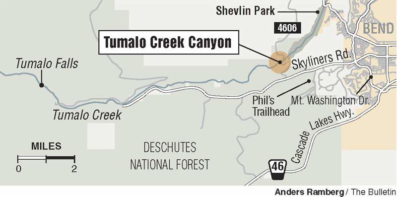
- Tumalo Creek
When it comes to hiking spots close to home, I thought I had it covered. First Street Rapids: Check. Pilot Butte: Check. Lava Butte, Shevlin Park, Tumalo Falls, Dry River Gorge, Dillon Falls, Benham Falls: Check, check, check, double check, check.
All are great spots that I’m grateful are nearby, but they just aren’t new to me anymore. That’s why I felt a bit of a thrill to discover a trail just a few miles from Bend that I had never heard of.
Tumalo Creek Trail west of Bend follows the creek as it rambles and rushes eastward after tumbling down dramatic Tumalo Falls.
To get there, my husband and I headed out Skyliners Road a few miles past Bend’s new Miller Elementary School. From there it was a quick trip, less than two miles of gravel road.
The trail starts on the left side of the gravel road, just after it crosses the creek. There is room for a few cars to park.
Because the trail is close to town and is one of the lowest-elevation trails on Forest Service land in the area, it should remain snow-free for a while, unlike the trails farther west next to Tumalo Falls that typically become snow-logged sooner in the season.
The fall colors were out in full force for my trip last week. I was surprised to see so many of what I thought were conifers to be turned a golden-yellow color. Each one of the several dozen we saw struck me as a special glowing treat. Turns out the trees are Western larch. Jo Booser, a silviculturist with the U.S. Forest Service, said these trees are in fact deciduous and will lose their needles at some point each fall. She says more can be spotted on the edges of the Metolius basin and in the Ochocos.
From the trailhead, the path immediately begins to ascend a canyon wall through a series of switchbacks. A sign at the beginning warns that this path is “most difficult” and I could see why right away. While the elevation gain is speedy, the “difficult” part is really the path itself. Manzanita bushes and their craggy branches creep onto the path from many angles. Large boulders block the trail in several spots. And the path goes over and across numerous rocks. Every few steps, I found myself balancing on top of a stone or climbing over one.
After climbing straight up for about 0.2 miles, we reached a sort of summit. We could see the creek and bridge far below. To the east, we spotted the rise of Awbrey Butte, and everywhere we looked, the hillsides were dotted with colorful trees. At the top of the trail, the path dead-ends into a giant rock outcropping, where you can see signs of rock climbing.
The faces of the cliffs are beautiful, arranged in various shapes with different shades of color. From the top, the trail veers off left and right, and a small sign gave us two options. Heading right promised us Fremont Meadow in 1.1 miles, which is part of Shevlin Park. Heading left, we would hit Columbia Southern Canal in 3.4 miles.
Meadows always sound nice, so to the right we went. After just a few steps, the path crosses a few giant rocks, which we scrambled across. Then, it becomes covered with bushes. Less than a quarter mile in, the trail essentially abandoned us. My husband walked ahead, catching glimpses of what he thought was a path here and there. We followed several phantom trails that led nowhere. After about 20 minutes of searching around over boulders and through bushes, we gave up and headed back to the sign. From there, we took the path to the canal.
While this trail is still plenty difficult, with dozens of large rocks to cross and fields of smaller rocks to navigate (and avoid twisting an ankle), it is at least a trail that seemed to be taking us somewhere.
We followed the trail for about two miles. The path sits just below the top of the canyon ridge and far above Tumalo Creek. The creek isn’t always visible, but it is always audible. I love listening to the sound of rushing the water as it bounces off the rocks.
Add the bursts of yellow trees and giant rocks in interesting shapes and you’ve got a trail full of lovely vistas. When we reached a large outcropping that hangs over the creek below, we paused to take a few pictures and then decided to head back. Perhaps if we hadn’t taken the false start down the other trail — and if the clouds weren’t looking so ominous — we would have made it to the canal. We promised to come back sometime soon and make it all the way.
While the path is challenging, I enjoyed the fun of scrambling over rocks and trying to figure out which stone to step on to find stable footing. This kind of hiking is like a puzzle you solve with your legs and feet. Can I stretch to reach the good foot placement? Will this rock hold my weight? Do I need to put the camera back in its holster in case I lose my balance?
But this kind of trail isn’t for everyone. While some older kids would no doubt love the challenges and tons of places to climb, I would caution against bringing young children or pooches. It is also not suitable for individuals with any kind of mobility issue.
Personally, I loved getting to know another nearby option for hiking.
If you go
What: Tumalo Creek
Getting there: From Bend, take Galveston Avenue west, which turns into Skyliners Road. About 2.4 miles west of the roundabout with Mt. Washington Drive, turn right on a dirt road and left after one-tenth of a mile onto Road 4606. Drive 1.5 miles to the bridge across Tumalo Creek.
Difficulty: Moderate to difficult
Length: From trailhead to Columbia Southern Canal is 7.2 miles round trip
Cost: Free

Best of the Best of Bend 2025

-
-
-