Outing to Hand Lake
Published 5:00 am Thursday, August 12, 2010
- Outing to Hand Lake
If you’re looking for an uncrowded, beautiful and accessible outing, you’ve come the right place.
Let me tell you about Hand Lake.
It’s got everything you might want: a lush, wooded trail, wildflower-laden meadows, mountain views and an alpine lake. And, best of all, the basic hike is just about one mile round-trip, making it an easy outing for families with kids.
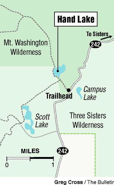
The trail to Hand Lake begins at the McKenzie Pass Highway, just a few miles west of Dee Wright Observatory. From Sisters, the drive is about half an hour.
We set out on a recent hot day, when being in town felt like roasting yourself in an oven. About five miles beyond the observatory, the trail to Hand Lake begins. It is not very well marked; look for a sign with the hiker symbol between mileposts 72 and 73.
As you’re driving west, the pullout is on the left side of the road near a meadow. There’s enough space here for several cars to park. The trail starts on the opposite side of the road.
The trail begins at a meadow and dives immediately into a lush evergreen forest.
After about a half mile, we reached a three-sided shelter and the edge of Hand Lake.
The lake is shallow and, at the end closest to the trail, somewhat marshy. At the far end, a lava flow abuts the shore. Mount Washington peeks out from behind the valley here, completing a quintessential Central Oregon tableau.
It’s worth the hike around the lakeshore for a view of North and Middle Sisters. The mountains still had snow on them, and the sight of them rising up over the clean water of the lake ~ well, the only words I can find seem trite.
The water itself felt much warmer than many other alpine lakes. We wished we had brought swimsuits for a quick dip.
As it was, we sat by the edge of the lake and ate a snack, staring at the mountains and reveling in the mountain air. We almost felt guilty that we had only hiked half a mile to get here. There was no one around, the sun was shining and the mountains were glistening.
The bugs were a nuisance, though by no means intolerable. Still, visitors would be wise to pack repellent.
We hiked back the way we came. We could have, however, lengthened the hike a bit, taking a right turn at the shelter and looping around past an old lava field and part of an old wagon road that was used to carry mail across the pass in the latter half of the 19th century.
The loop lengthens the hike by about a mile and a half, bringing the total length to two and a half miles.
On the way back along the highway, there are plenty of places to stop. John Craig, a mail carrier who helped build the old wagon road near Hand Lake, is memorialized a few miles east of the Hand Lake pullout along the highway.
For us, no hike near Sisters is complete without a milkshake from the Sno Cap Drive In in Sisters. My husband got orange; I got blackberry.
If you go
What: Hand Lake
Getting there: From Sisters, drive west on McKenzie Pass Highway (state Highway 242). About 4.5 miles past Dee Wright Observatory, between mileposts 72 and 73, park at the roadside pullout on the left, near a hiker symbol. The trailhead is across the road.
Cost: Free.
Difficulty: Easy
Contact: McKenzie Ranger District, Willamette National Forest, 541-822-3381


Best of the Best of Bend 2025

-

-
-