Smith Rock
Published 5:00 am Thursday, March 24, 2011
- This view is from Staender Ridge, looking down on Burma Road, bottom left, and the Crooked River in Smith Rock State Park last week.
Ask any climbers, and they’ll tell you: Smith Rock is a magical place.
They might be referring to the deep, rich, red and yellow patinas of the rock or the sheer magnitude of the 550-foot-high vertical walls.
Trending
But Smith Rock’s true supernatural ability is an uncanny knack for avoiding bad weather. It’s true. When rain or snow chases me off my climbing destination, I invariably head toward Terrebonne, and I’ve never been disappointed. The park seems to ignore the meteorological trends that envelop Central Oregon, offering an oasis of passable if not sunny conditions in a desert of stormy weather.
Just last week, I was hoping to take advantage of the change in time and head out for a hike after work. Conditions in Bend had been pretty miserable, with nary a hint of the 250 days of sunshine the visitor bureau promised me when I relocated to Central Oregon. But I had faith that Smith Rock wouldn’t let me down. Despite the light drizzle as I left the office and headed north, by the time I reached Terrebonne, the rain had abated. When I pulled into the day-use parking lot at Smith Rock, it was completely dry.
I spend a few days each year climbing at Smith Rock, and on most summer weekends, it’s tough to find a parking spot. But on a weekday evening in mid-March, there were few cars in the lot.
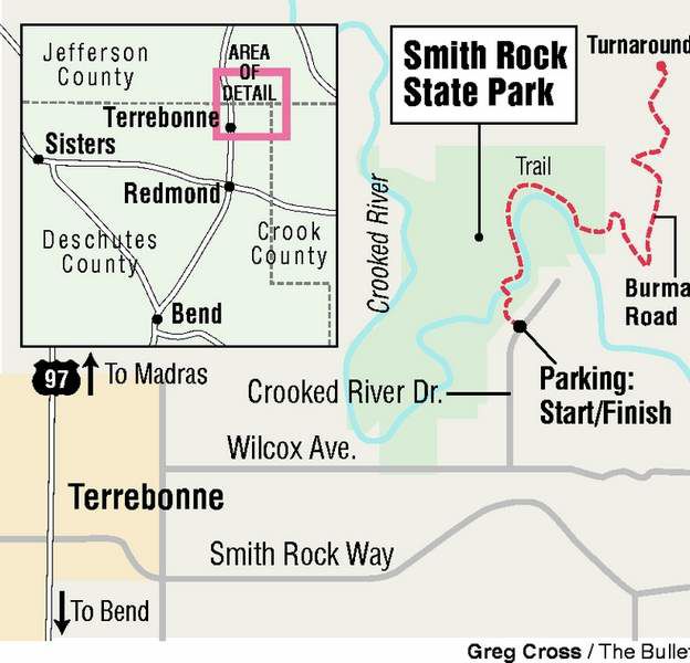
Smith Rock is a climber’s paradise with more than 1,500 climbing routes on rock made of compressed volcanic ash, known as welded tuff. But the park is a wonderful destination for nonclimbers as well. There are trails for hiking, mountain biking, even horseback riding on its 650 acres.
My guess is most hikers stick to the same routes, following the trail alongside the river or climbing up and over Misery Ridge for a face-to-Monkey-Face view of the park’s most famous pillar.
Those are the trails I take as well when I’m showing an out-of-town visitor the park. But with only a few hours before darkness would envelop the park, I opted to explore a part I’d never visited before. I crossed the river on the footbridge and turned right.
Trending
Initially this trail follows the river, and eventually meanders closer to the rock formation known as The Monument. Currently The Monument is closed to climbing because a pair of golden eagles is nesting on its cliffs.
I continued along the easy trail around the big bend in the river. About a mile from the bridge, the trail splits and starts to climb in earnest to a junction with Burma Road. Both trails will take you to the road, but the left is a little gentler than the right.
I was headed for Marsupial Crags, a part of the park more frequently climbed in the 1950s and 1960s than it is today. Individual formations in that part include a who’s who of the animal kingdom Down Under: the Koala, the Wombat and the Kangaroo.
There’s a scrambling route involving no technical climbing that comes close to the tops of the Koala and the Wombat, and because I didn’t have a climbing partner with me, it was a safe alternative.
The route up to the Marsupials follows a trail from where Burma Road takes a hairpin turn to the north. But when I arrived at the trail, I found a brown metal marker standing slightly askew in the rocks announcing the area was closed for natural preservation. I saw a couple of large birds circling over the top of the Marsupials and wondered whether the area was also closed for nesting raptors. But it hadn’t been marked on the poster describing the closures at the parking area.
I wasn’t going to be able to do the scrambling route I wanted, but as I said, Smith Rock is a magical place and I could certainly enjoy hiking through the park instead. I continued up the road past an open gate and up onto Staender Ridge, to where Burma Road crests and drops down onto the other side of the ridge.
There at the high point of the road, I climbed up a small rock formation and found a small ledge. It was the top of a rock-climbing route coming up the sheer cliff on the other side of rock formation. There were two metal anchor points, into which the lead climber can clip the rope and hold his or her partner in the event they fall. They can walk off the route the way I came up, or use the anchor points to rappel back down the climb.
I sat on the ledge admiring the view. If there were other people in the park, I certainly couldn’t see them. I felt as if I had the park to myself.
From my perch I could see the entire southern half of the park. If you tried to design a scenic state park, I’m not sure you’d do it any differently. Put a winding river at the bottom of a deep canyon. Line the river with basalt cliffs on the far side, and massive towers of rock on the other. And of course, make it immune to bad weather.
As the daylight waned, I hiked the 2 1/2 miles back to my car. Sure enough, as I drove the winding back roads from the park to the highway, it began to rain.
If you go
Getting there: From Bend, take U.S. Highway 97 north to Terrebonne. Turn right at Smith Rock Way and follow the signs to the park.
Difficulty: Moderate
Cost: $5 day-use permit
Contact: www.oregon stateparks.org/park_51.php or 541-548-7501
Marketplace


Best of the Best of Bend 2025

-
eEdition

-

-