Touring Oregon’s covered bridges
Published 5:00 am Sunday, April 10, 2011
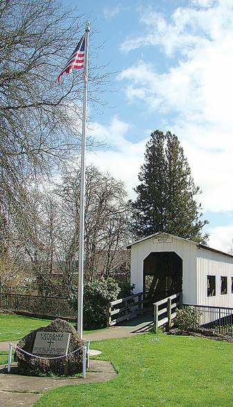
- The Centennial Bridge, a three-eighths replica of the nearby Chambers Railroad Bridge, was built for Cottage Grove’s 100th birthday in 1997. The pedestrian bridge over the Coast Fork of the Willamette River symbolizes the town’s claim as the “Covered Bridge Capital of Oregon.”
DRAIN — There’s a romance about covered bridges that doesn’t extend to more modern spans of concrete or steel.
Maybe it’s inspired by 19th-century Currier and Ives prints of horse-drawn carriages crossing bridges in the snow. Perhaps the poems of Longfellow or Robert Frost are to blame. Childhood memories of family vacations could be responsible.
Trending
Whatever the reason, the scene I observed on Drain’s Pass Creek Bridge likely wouldn’t have been repeated on a contemporary structure.
A young couple stepped softly onto the old covered bridge, pausing to study the fading paint on its brown-painted slat walls and the speckled moss on its shingled roof. Then they took each other’s hands and virtually waltzed through the span, stopping once or twice to snap photographs along the way.
A covered bridge has crossed this Umpqua River tributary since the 1870s, when Drain was a key road junction along the Overland Stage Route linking the Willamette Valley with Southern Oregon. Rebuilt in 1925, it was closed in 1981 and replaced by a more permanent concrete bridge over Pass Creek.
But like many Oregon towns that are keenly aware of their heritage, Drain wasn’t willing to say farewell to the Pass Creek Bridge. In the fall of 1987, a 90-ton crane lifted its trusses and moved the structure one block east — to a quiet, park-like area behind the Drain Civic Center on West A Street — where its roof and siding were reassembled.
While covered bridges are generally associated with the northeastern United States, especially New England, no Western state has more than Oregon’s 51. Nineteen of those are in Lane County, just over the Cascade summit from Central Oregon.
Only one official covered bridge east of the Cascades is acknowledged by the Covered Bridge Society of Oregon, and it’s on the north side of Bend. The privately owned Rock o’ the Range Bridge, built in 1963, is on Bowery Lane immediately west of U.S. Highway 97.
Trending
Shevlin Park, meanwhile, boasts the Hixon Crossing Covered Bridge over Tumalo Creek. Built in the early 1990s by a movie company, the pedestrian-only bridge rests on the footings of a rail trestle dismantled in 1957.
Many of the state’s covered bridges are no longer used for vehicular traffic, having been bypassed by modern steel or concrete spans. But more than half of Oregon’s bridges — 31 by my count — continue to accommodate cars, albeit with posted height and weight restrictions.
Other bridges are preserved as heritage landmarks and accommodate pedestrian traffic.
Two-thirds of Oregon’s covered bridges were built in the 1920s and 1930s, many of them replacing late-19th-century structures. While construction techniques varied, the most commonly used was the “Howe truss,” according to the Covered Bridge Society. By this method, support beams were latticed and placed at angles in a series of “X” patterns between the bridge’s upper and lower beams, and held by iron rods.
Westfir, Lowell bridges on state Highway 58
Two of my favorite Oregon covered bridges — those at Westfir and Lowell — are easily accessible from state Highway 58, the Willamette Pass road that links Eugene with U.S. Highway 97 between Bend and Klamath Falls.
The history of Westfir’s Office Bridge is inextricably bound to that of the company lumber town in which it is located. Oregon’s longest covered bridge — 180 feet over the North Fork of the Middle Fork of the Willamette River — was built in 1944 by the Westfir Lumber Co. Linking the sawmill to company offices on the east side of the river, it featured a covered walkway separate from the roadway, so that pedestrians could share the bridge with logging trucks.
Its lumber mills long ago closed after a series of 1984 fires, Westfir is now home to fewer than 300 people and is primarily a residential suburb of Oakridge, four miles east. Lane County took ownership of the bridge in 1992, did extensive work to stabilize its condition, and 10 years later added a new roof. Today, the Office Bridge crosses to a small county park with hiking and bicycling trailheads, and its deep red color, recently touched up with a new coat of paint, makes it a regional landmark.
To reach the Office Bridge, turn north off state Highway 58 near milepost 31 just west of Oakridge. Cross the steel bridge and turn left on Westfir Road. The bridge and mill site are about 2 1/2 miles ahead.
To get to Lowell, continue northwest on state Highway 58 about 21 miles beyond the Westfir turnoff (or 19 miles east of Eugene).
A new interpretive wayside makes the Lowell Bridge — built on the Middle Fork of the Willamette River, but now crossing a section of Dexter Reservoir — one of Oregon’s most intriguing stops for curious travelers.
The first wooden bridge at this site was built in 1907 in place of a river ferry. It was replaced in 1945 after being damaged by a truck accident, and raised six feet in 1953 as the Dexter Dam was being constructed. When Dexter Reservoir inundated the area in 1955, the bridge remained two feet above the high-water level.
Traffic was rerouted over a modern concrete bridge in 1981. But the original covered bridge, 24 feet wide, was preserved as a historic landmark. In 2006, a partnership between state and federal agencies established the Lowell Covered Bridge Interpretive Center on the north side of the bridge, featuring extensive outdoor displays that tell the history of the Lowell area, Lane County’s covered bridges and, in particular, the Lowell Bridge.
Three other historic covered bridges are within a 10-minute drive of Lowell Bridge. The 1936 Unity Bridge over Fall Creek is located two miles north of Lowell on the Lowell-Unity Road. The 1938 Pengra Bridge is located about halfway between Jasper and Lowell on Fall Creek. And the 1921 Parvin Bridge, now being rebuilt, takes traffic over Lost Creek on Parvin Road, about two miles south of Dexter.
Other bridges in Lane County
Two covered bridges are easily seen by McKenzie Highway travelers. Opened in 1966 to replace a predecessor destroyed in a 1964 flood, the Belknap Bridge is the fourth bridge to cross the McKenzie River in its same location since 1890. It’s on King Road West off McKenzie River Drive, between Rainbow and the town of McKenzie Bridge.
Oregon’s second-longest covered bridge (165 feet), the Goodpasture Bridge crosses the Mc-Kenzie River just west of Vida. Built in 1938, it was renovated in 1987 to handle crossings by heavy logging trucks. The bridge is situated off state Highway 126 about 25 miles east of Springfield.
Two more bridges are in the Mohawk River Valley northeast of Springfield. During the filming of the 1965 movie “Shenandoah,” starring James Stewart, the 1938 Earnest Bridge was altered by the film company to more closely resemble Civil War-era design. When filming was completed, the producers restored the bridge to its previous condition. It is a couple of miles northeast of Marcola on Paschelke Road, just off Marcola Road. Nearby Wendling Bridge, which crosses Mill Creek, is three miles northeast of Marcola on Wendling Road.
Cottage Grove fancies itself the “Covered Bridge Capital of Oregon,” according to its Chamber of Commerce literature. The miniature Centennial Bridge, three-eighths actual scale, was built for the town’s 100th birthday in 1997. It presents a charming pedestrian walkway crossing the Coast Fork of the Willamette River on Main Street. Two miles south, the only covered railroad bridge west of the Mississippi River, the Chambers Bridge, is under reconstruction, with completion scheduled for November.
The Mosby Creek Bridge and Stewart Bridge are less than 1 1/2 miles apart on Mosby Creek, a Row River tributary east of Cottage Grove. Built in 1920, the Mosby Creek Bridge is Lane County’s oldest. Flooding and heavy snowfall took their toll in the 1960s on the 1930 Stewart Bridge, which was bypassed by a concrete span in 1987. Today it welcomes visitors to the popular swimming hole beneath the bridge. Two miles north of the Mosby Creek Bridge on Layng Road is the Currin Bridge, erected in 1925 to replace the original Row River Bridge. It now serves only pedestrians.
Dorena Bridge was built in 1950 to span the Row River when the old mining camp of Dorena was flooded by the creation of Dorena Reservoir. A new road bypassed the bridge in 1974, but it was reconstructed in 1996. Today it is the centerpiece of a wayside park at the junction of Government and Row River roads, 12 miles east of Cottage Grove.
Eugene-area winery visitors cross the picturesque Coyote Creek Bridge as they travel on Lane County’s original 1851 Territorial Highway. Also known as the Swing Log Bridge, this structure over Coyote Creek was erected in 1922, one mile south of the community of Crow.
Three of the Lane County bridges are in the Oregon Coast Range. Built in 1925, the Wildcat Creek Bridge was on the original Stagecoach Road that connected Eugene with Swisshome. Today it stands along state Highway 126 beside the Siuslaw River, near the Austa boat launch popular with fishermen.
The Lake Creek Bridge, built in 1928 and refurbished in 1984, is located on Nelson Mountain Road near Greenleaf. The Deadwood Bridge in Siuslaw National Forest was once closed because of its poor condition, but it was fully restored in 1986.
Its unique, original 1932 construction features a slanted floor, designed for greater safety for traffic rounding the corner onto the bridge. Both bridges are off state Highway 36 west of Junction City.
Linn County bridges
There are eight bridges in Linn County, three of them along the Santiam Pass-to-Brownsville highway corridor and five more in the Scio area.
Just past tiny Cascadia, on High Deck Road off westbound U.S. Highway 20 from Central Oregon, is the Short Bridge. The last remaining covered bridge of several that once crossed the South Fork of the Santiam River, it was built in 1945 with a wooden shingle roof.
The open-sided Weddle Bridge spans Ames Creek in Sweet Home’s Sankey Park, where it stands as a source of community pride. Originally built in 1937, the bridge stood across Thomas Creek, near Scio, for half a century. When it was scheduled for demolition in 1987, Linn County bridge activists vehemently protested. The state Legislature created the Oregon Covered Bridge Program to fund maintenance and rehabilitation programs around the state, and the Weddle Bridge became the first grantee. It was rebuilt in Sweet Home in 1990.
Grant funds have also helped with the upkeep of the 1932 Crawfordsville Bridge, which crosses the Calapooia River eight miles west of Sweet Home, just off state Highway 228. Not used by traffic since 1963, the bridge is maintained by the Linn County Parks and Recreation Department and volunteers from the Covered Bridge Society.
Five charming bridges surround Scio in all directions, none of them more than 11 miles outside of the little town. Nearest is the 130-foot-long Shimanek Bridge, three miles northeast on Richardson Gap Road. Built in 1966, it is the fifth bridge since 1891 to cross Thomas Creek at this location; all of its predecessors were destroyed by high water or wind damage.
Others are the 1936 Hannah Bridge, spanning Thomas Creek seven miles east of Scio on Camp Morrison Drive; the 1939 Gilkey Bridge, also crossing Thomas Creek, four miles southwest on Goar Road; the 1936 Hoffman Bridge, over Crabtree Creek eight miles southwest on Hungry Hill Road; and the 1939 Larwood Bridge, 11 miles southeast on Fish Hatchery Drive. All are open to vehicular traffic, but the Larwood Bridge is the most intriguing of the group. It crosses the Roaring River, which according to “Ripley’s Believe It or Not!” is the only U.S. river to flow into a creek (Crabtree Creek), rather than vice versa.
Willamette Valley
There are eight other bridges in the Willamette Valley. None is more accessible than Irish Bend Bridge on the Oregon State University campus. Built in 1954 across the Willamette Slough, 15 miles south of Corvallis on Irish Bend Road, it was dismantled in 1988 and reconstructed on the west side of campus, off 53rd Street near the Benton County Fairgrounds.
Also in Benton County are the Harris and Hayden bridges. The 1936 Harris Bridge, 12 miles west of Corvallis near Wren, is just off U.S. Highway 20. Hayden Bridge, constructed in 1918 and rebuilt in 1945, is two miles west of Alsea via state Highway 34.
A mile north of Silverton, the 1917 Gallon House Bridge over Abiqua Creek was so named for its use as a liquor drop: A nearby dispensary made the bridge its station for selling gallons of whiskey to Silverton residents. A 1990 restoration returned the bridge to mint condition. Drivers can reach the bridge via state Highway 214 and Hobart Road.
Marion County’s only other covered bridge rests in Stayton’s Pioneer Park. Built in 1998, the Stayton-Jordan Bridge was constructed in response to heartbreak. Ten years earlier, Stayton residents had rebuilt the historic Jordan Bridge, which for 50 years had spanned Thomas Creek near Scio. Dedicated in 1988, it burned to the ground six years later when Christmas lights ignited the roof. Citizens responded with the new bridge.
Polk County’s Ritner Creek Bridge was the last covered bridge to be situated on an Oregon state highway. It was constructed in 1927 and moved a short distance downstream in 1976 when a modern concrete bridge replaced it on state Highway 223, south of Pedee.
Multnomah County’s Cedar Crossing Bridge, built in 1982 over Johnson Creek in southeast Portland, has a five-foot walkway that separates pedestrian and bicycle lanes from the 24-foot roadway. Five large windows illuminate a knotty-pine interior. To reach it, turn east on Foster Road off Interstate 205, then south on 134th Street to Deardorf Road.
Coast Range bridges
In the foothills of the Oregon Coast Range, there are four bridges in Lincoln County. Most northerly of the quartet is the Drift Creek Bridge, one mile south of state Highway 18 on Bear Creek Road, just east of Lincoln City. Built south of Lincoln City in 1914, it was closed in 1988 and dismantled in 1997. The Sweitz family resurrected the bridge eight miles north, in a small, parklike setting on Bear Creek, and opened it to the public in 2000.
The Chitwood Bridge, which crosses the Yaquina River 17 miles east of Newport off U.S. Highway 20, was built in 1926 and reopened after restoration in 1986. Farther south, seven miles east of Yachats, the restored North Fork Yachats Bridge was built in 1938 on the North Yachats River Road. The Fisher Bridge, further east at the remote hamlet of Fisher, was built in 1919 and later restored. It is most easily reached off state Highway 34, turning south on Forest Service Road 141 about 20 miles west of Alsea.
The only covered bridge in Coos County, the 1921 Sandy Creek Bridge, is located in a wayside park near the one-shop village of Remote, just off state Highway 42 between Roseburg and Myrtle Point. No traffic has crossed the bridge since 1949.
Southern Oregon
The Pass Creek Bridge is the most northerly of Douglas County’s six covered bridges.
The Rochester Bridge, three miles northwest of Sutherlin via state Highway 138 and Sterns Lane, was built across Calapooya Creek in 1933. The 1943 Cavitt Creek Bridge, seven miles south of Glide on Little River Road, was built to handle heavy usage by logging trucks. The Horse Creek Bridge, built in 1930 near Cottage Grove, was relocated in 1987 to cross Mill Site Park in downtown Myrtle Creek. The 1929 Neal Lane Bridge, south of the town off Riverside Drive, is a mere 42 feet long.
The Milo Academy Bridge, owned by a Seventh-day Adventist academy, is the state’s only steel bridge to be housed in wood. Located 20 miles east of Canyonville on state Highway 227, it was built in 1962.
The Grave Creek Bridge at Sunny Valley, 16 miles north of Grants Pass, can be seen by travelers on Interstate 5. Josephine County’s only covered bridge was built in 1920 and reopened to traffic in 2001 after repairs. The bridge features six Gothic-style windows on each side.
After the 1927 Wimer Bridge, Jackson County’s only covered vehicular bridge, collapsed in 2003 under the weight of cars and trucks, a community group mobilized and rebuilt the structure in 2008. Wimer is seven miles north of Rogue River on East Evans Creek Road.
The 1922 Little Butte Creek Bridge was renamed the Antelope Creek Bridge when it was moved in 1987 to Eagle Point, where it now stands at Main Street and Royal Avenue in Eagle Point. Sixteen miles east near Lake Creek is Oregon’s shortest covered bridge, the 39-foot Lost Creek Bridge. Closed to traffic since 1979, it may have been built as early as 1878, although it was partially reconstructed in 1919.
Crossing the Applegate River only eight miles from the California border, the McKee Bridge served mainly logging and mining traffic from 1917 to 1956. Since being declared unsafe for vehicles, it has remained open for Rogue National Forest hikers. A riverside picnic ground is at the west end of the bridge, 8 1/2 miles south of Ruch off state Highway 238 near Jacksonville.
Marketplace


Best of the Best of Bend 2025

-
eEdition

-

-