Tumalo Falls
Published 5:00 am Thursday, June 23, 2011
- Tumalo Falls
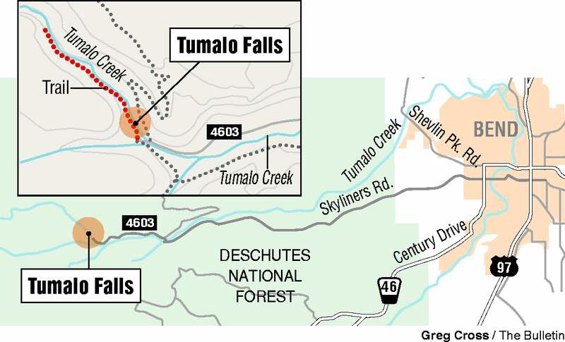
Last Wednesday, I loaded up the car and drove to one of Bend’s best hiking bets, Tumalo Falls, just a 12-mile drive from town.
Along for the trip was Map Guy, an occasional outing companion who’s great with a Global Positioning System, if by “great,” you mean he can balance such a device on his head (he claims it’s the best way to get an accurate reading).
Map Guy has an easygoing, agreeable manner that’s offset by his occasional need to complain. For example, we’d talked about taking out my canoe instead of hiking, and, during the hike, even though we weren’t technically canoeing, he managed to complain that had we gone canoeing, he’d have been stuck with a pink life preserver.
Tumalo Falls is an ever-popular place, but I was still slightly surprised to find the parking lot nearly full at 11:30 a.m. on a weekday. Judging from the dozens of people we saw hiking or just taking in the beauty at the scenic viewpoint adjacent to the parking lot, Tumalo Falls is nobody’s secret.
I’ve been there enough times in a decade of living in Bend that just hearing or seeing that combination of those two words, “Tumalo” and “Falls,” evokes in my mind’s eye a dusty road, a spilling waterfall, spraying mist, glistening rocks, wildflowers and well-used trails.
Ensconced in the indoors, I might even be able to muster a smidgen of nostalgia for the mosquitoes one occasionally encounters at Tumalo Falls, that occasion usually being the one time you’ve forgotten insect repellent, as we did.
Fortunately, if the mosquitoes were biting, they were feasting on someone else the day we visited. About the peskiest thing I encountered on the trail slightly beyond Double Falls was Map Guy asking me if I was going to talk to any other hikers on the trail.
“Are you SHY?” my avuncular companion teased. Easily manipulated by such an accusation, I felt I had to prove myself not shy, namely, by accosting innocent hikers trying to enjoy their tour of the falls area.
Our first stop was at the scenic viewpoint to gawk at the 97-foot waterfall, which never fails to impress, especially when the weather warms and runoff is high. From there, we began the winding, five-minute march up to the top of the falls, where a rock wall and railing are all that separate you from the gushing water. Before I took the obligatory photo holding my camera over the spilling waterfall, I made sure to wrap its cord around my wrist.
From there, we hiked up on North Fork Trail that parallels Tumalo Creek. Another mile or so of hiking led us to Double Falls, where there are a pair of beautiful 20- and 30-foot waterfalls.
Shortly after, we encountered Kay Roberts, 63, hiking solo back down the alternately snow-free and snow-covered trail. Formerly of Kansas City, she and her husband moved to Portland a couple of years ago to be closer to her adult children. They were in town last week to attend Art in the Mountains art workshops.
“In Kansas City, you can go to the mountains in 12 hours or more. You can go to the ocean in a lot longer time. Here, in Portland, an hour away, you got Mount Hood … and in Portland, they like old people too, so that’s not bad,” she said, laughing. “I’ve walked all over Bend.”
Roberts had just turned around on the trail, saying she was not equipped for the snow. She did have a pretty great makeshift walking stick that could have doubled as a divining rod.
“Improvise,” she said.
In all, Map Guy and I made it maybe another half-mile past Double Falls, if that far, though Map Guy thought we went another mile. The snowline is receding with the warmer temperatures, and according to Chris Sabo, trails specialist for Deschutes National Forest, those who try to go along in boots risk postholing, or sinking in soft snow. Should you pack snowshoes, you may yet run into a doozy of a problem: the trail is not signed for winter, and it’s easy to become disoriented when the trail is buried in snow.
“They won’t be able to follow the trail very well,” Sabo says. “We have had people going in over snow and getting lost before.”
I received one mosquito bite when Map Guy and I stopped for a breakfast cookie snack. As weather warms, at least around Tumalo Falls, mosquitoes are bound to get worse.
“That one will become 1,000, and then 10,000, and then 100,000,” Sabo says, predicting that peak mosquito season will probably be late June or early July, perhaps even late July for higher elevations.
He also has a heads up for mountain bikers. The North Fork Trail, which is uphill-only for mountain bikes, is closed until bikers can complete the Mrazak or Flagline loops.
“Bikers cannot go up that trail until they can go all the way up and around, because then they end up coming down the trail (after) hitting the snow,” Sabo says. He predicts it may be late July before bikers can use the trail.
The crowds already amassing at Tumalo Falls are evidence that when the weather begins to warm, people get a little desperate to get out there.
Be patient, says Sabo. Due to heavy snowfalls last winter, there is still a lot of snow to contend with, and it’s probably going to stick around a bit longer than usual.
“There are a lot of trails people can’t access, so they’re chomping at the bit to get some of that higher elevation, but this is just a taste of what they’re going to encounter at other trailheads, too. Snow is going to be holding in; I’m giving it three to four, maybe even five weeks later than normal for some areas.”
If you go
Getting there: From Bend, proceed 11.6 miles west on Skyliners Road (4601). After crossing over Tumalo Creek, turn left and proceed 2.6 miles west on Forest Road 4603. Be aware of the potential for numerous other cars zipping along this gravel road.
Difficulty: Moderate
Cost: Northwest Forest Pass or $5 day pass required
Contact: Deschutes National Forest, 541-383-5300


Best of the Best of Bend 2025

-
-
-