Your guide to the Haulin’ Aspen trail runs
Published 5:00 am Friday, August 5, 2011
- Your guide to the Haulin' Aspen trail runs
Because much of the action in all three races occurs on Bend-area trails and on point-to-point courses, Haulin’ Aspen is not as friendly for spectators as some other running events. But you can still catch some of the most important moments during the start at William E. Miller Elementary School and at the finish at Aspen Meadows in Shevlin Park. Between those two locations, most of the courses wind along singletrack trail and U.S. Forest Service roads.
Marathon: The 26.2-mile marathon course includes more than 2,300 feet of elevation gain and more than 2,500 feet of elevation loss. That’s a lot of up and down, even for a marathon. After leaving Miller Elementary School, runners will make their way along the trail that parallels Skyliners Road, after which they will briefly enter the Phil’s Trail network and run a short stretch along Ben’s Trail. After crossing back across Skyliners Road, the marathoners will do about 10 miles along the Mrazek Trail, into Shevlin Park, where they will run on the trails alongside Tumalo Creek before hitting the finish line.
“(The Mrazek) is such an amazing trail,” says Gina Miller, marketing and sports event director for Lay It Out Events, which puts on Haulin’ Aspen. “It’s all singletrack. It’s pretty smooth. It’s great.”
Participants can expect to do almost all of their climbing on the first half of the course and then enjoy a long descent to Shevlin Park, whose boundaries include the last couple miles of the course.
“It’s green and lush and fairly shaded in that area,” Miller notes of the homestretch. “The last couple miles are pretty cushy.”
Half marathon: The course for the half marathon, 13.1 miles in length, covers much of the same ground as its marathon counterpart, but participants will run about seven miles along the Mrazek Trail instead of 10. The route gains about 700 feet of elevation and loses about 900. Participants will encounter a relatively gentle but sustained climb for the first three miles, followed by a short, mostly downhill stretch. A little more than four miles into the race, runners will tackle the course’s most significant challenge, a climb of approximately three miles with about 400 feet of elevation gain. But from there, it’s pretty much all downhill to the finish in the park.
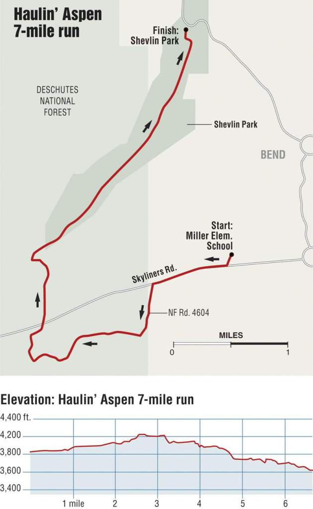
7 miles: The 7-miler is a relatively flat affair in which participants will run gradually uphill for about the first three miles. The rest of the course is a slightly steeper but still gentle downhill grade to Shevlin Park. The course gains 265 feet in elevation and loses about 470. Much of the last half of the course is located inside the park.
At the finish, participants will be able to replace some of those burned calories with eats and drinks including burritos, baked goods and beer at a beer garden.
Miller points out that hardier spectators can watch the races along the trails. She notes that 5,000 small flags will dot the course to direct participants. Those willing to get out early — so as not to kick up clouds of dust for the racers — can also follow those flags to find their own cheering spots, where they may provide a welcome diversion from the relative solitude of trail running.
— Amanda Miles
More Local News


Best of the Best of Bend 2025

-
-
-