Exploring Owyhee’s untouched wilderness
Published 5:00 am Sunday, August 28, 2011
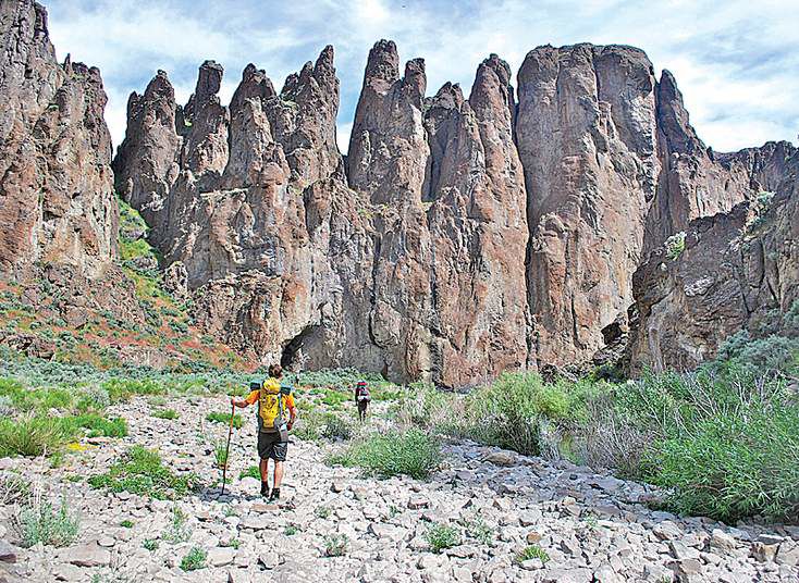
- Hikers trek near rock pillars above Louse Canyon in the Upper West Little Owyhee Wilderness Study Area of southeastern Oregon in June.
On a chilly afternoon in late June, we stood contemplating our options in an icy Oregon rain that pricked our skin like needles. The canyon’s 300-foot-high walls of chocolate rhyolite had corralled the river into a pool too deep to wade through, too cold to swim in. Turning back would mean a grueling two-day retreat upstream. If we pushed ahead we could be out in a day. The decision was painful but clear: time to strip and swim.
Brent Fenty, the 37-year-old executive director of the Oregon Natural Desert Association (ONDA), a conservation group, ripped off his shirt and eased waist-deep into the water. Goosebumps rippled down his arms. His backpack bobbed before him.
“I’m not getting any braver,” he said.
Then he went for it, swimming for all he was worth toward a gravel bank 100 feet away. One by one, the five of us made it across.
It was day three of a four-day, nearly 50-mile exploratory hike through Louse Canyon in the Upper West Little Owyhee Wilderness Study Area of southeastern Oregon, and there was no doubt we were getting spanked. But unexpected swims like this came as no surprise because no one really knew what to expect.
About 350 air miles southeast of Portland, the West Little Owyhee River, a rarely visited tributary of the better-known Owyhee River, has cut a squiggle of a gorge through sandy expanses of sage and rye. The canyon is surely among the most inaccessible places in the West.
At its loneliest, the nearest human living under a proper roof is about 24 hours away by four-wheel drive, then horseback and foot. This cool crack in what is known as ION country, where Idaho, Oregon and Nevada collide, is so deep in the back of beyond that it sits in a different time zone from the rest of the Pacific Northwest. Our route would take us along the West Little Owyhee, from a rough dirt road at Anderson Crossing in the south to the river’s confluence with the main stem of the Owyhee in the north.
ONDA, which works to protect some 6 million acres of the high desert east of the Cascades, which run from California to Washington, has proposed a 700-mile-long hiking trail from Bend up to the Idaho state line that would wander along more than a dozen proposed wilderness areas that highlight the desert’s often overlooked magnificence. The plan is to have the route entirely surveyed next year, with maps and signage ready by spring 2014. Much of the trail — the more accessible parts — will follow existing game trails, hiking paths and old dirt roads used occasionally by ranchers. ONDA has already mapped close to 150 miles, using a seed grant from the Portland-based Lazar Foundation, ONDA membership fees and donations from local businesses to arm volunteers with GPS units and geo-referencing cameras to document where a hiker could find water, skirt a butte or make camp.
The section through Louse Canyon is the most rugged, complicated and largely unknown part of the proposal, so Brent assembled a small team of ONDA workers to survey it themselves. My friend Chris Solomon, a regular contributor to the New York Times travel section, and I tagged along for fun.
‘The dream is alive!’
While the Upper West Little Owyhee River corridor itself is federally protected as a Wild and Scenic River, the land surrounding it is not. On either side of the rim you can find the lower 48’s largest swath of roadless turf that has no permanent federal protection — about 2 million acres of nothing but nothing. The hope is that with accurate maps, signs and route descriptions people will go and stiffer protection will follow.
The five of us were all avid backpackers with considerable experience in trail-less country, and we set off confidently into the canyon under crisp blue skies. A wild horse crested a ridge as we made our way through shin-deep water and along gravel bars lined with sweet peas and wild roses. I stopped to photograph pinnacles protruding like a pipe organ into the sky and noticed tiny fish flickering around my ankles. Brent caught one, a northern pikeminnow, with his hands. Above us soared hoodoos, those Wile E. Coyote rocks perched atop thin pillars. There were graceful arches and even hoodoos with arches. It was exceedingly gorgeous, a Utah dipped in fudge.
“The dream is alive!” shouted Chris Hansen, ONDA’s 27-year-old Owyhee regional representative.
While such remote grandeur fueled our sense of discovery, this area of the Owyhee Plateau was actually first explored centuries ago by the Tagu, a band of Northern Paiute Indians who lived off wild onions, tubers and pronghorns that today still bound across the uplands. In 1819 Donald Mackenzie, a Canadian fur trapper, named the main river stem the Owyhee after Hawaiian trappers he sent down it never returned. (“Owyhee,” pronounced “oh-WHY-hee,” comes from the word “Hawaii”). In 1863, miners struck gold north of here, but with limited water and poor soil, no towns this far south took root.
Rough going
What has taken root, however, are thick stands of willows, and bashing through them is dreadful business. Within an hour of starting our hike a rubbery limb whipped my face so hard it left a bloody welt. Jeremy Fox, ONDA’s 31-year-old trail-mapping coordinator, slipped and toppled into the river. I was about to step on a rock but panicked when a rattlesnake lurking below made the consequences of that action clear.
“Just step back slowly,” Chris Hansen said, using a long piece of willow — his trusty “snake stick” — to scoot the snake along.
Soon all of us had snake sticks, their ends sheered off by beavers.
On that first night, we made camp on a pleasant bend in the river with a white gravel beach framed by towering gray walls. I swam in the crisp black water, which felt refreshing in the heat, as cliff sparrows darted around me, mating in midflight. It was magical, but the reality of the day was depressing: four hours of thrashing and we’d only covered four miles. At this rate we’d never make it out before our supplies and wits ran out.
“We don’t want to get to a point of no return where we can’t get out in time,” Brent said, after a dinner of corn chowder and hard-boiled eggs. “Tomorrow’s a big day. If it’s not going well, we’ll have to get out.”
But things went impressively well.
The GPS on day two said we’d covered a whopping 19 miles in 10 hours of hiking — a pace twice as fast as the day before. We climbed along Winnebago-size boulders, spotted golden eagles and waded around muffin-top crags. The canyon had grown no easier, but we’d learned how to move through it with the craftiness of water, aiming for the inside bends where the water was shallower and looking for small clearings in the willows so that we could push through more easily. At trouble spots we fanned out like commandos to find ways through in seconds rather than minutes. It was multisport backpacking at its best.
All hell broke loose that night as a hailstorm strafed our camp with marble-size missiles. In an effort to go as light and fast as possible, no one had brought a proper tent. Instead we slept under tarps or in weatherproof bags, called bivysacks, and the onslaught left us confined in synthetic coffins splattered in wet sand. In the morning even my energy bars were soggy in their unopened wrappers. A cold drizzle dragged temperatures down to the low 60s, with no sun to wring us out. Worse, we hiked only a few miles before we came to the pool we had to swim across to avoid a difficult retreat. The last thing I wanted to do was dive in, but Plan B — an arduous hike upstream — was worse. I shoveled in sugary pineapple chunks to stoke my metabolic fire. My heart exploded in my ribcage as I made the other side at last.
After a second, even colder pool, Brent and Chris Hansen were shivering uncontrollably, so we paused under a rocky overhang, did jumping jacks and boiled river water to drink.
“This is the best-tasting hot water I’ve ever had,” Chris Solomon said.
A place worth protecting
Only after we stopped shivering did we realize how truly beautiful a spot we were in. Tiny white wildflowers clung to cracks in the weeping walls. A red-tailed hawk circling overhead fired a shrill salvo that ricocheted off the marbled rock.
“If this had been a hot July day you’d be psyched,” Brent said. “Look at these pools! You’d want to play and swim.”
He was right. The place was surreal, a narrow fissure so well hidden a wagon train could fall in before anyone noticed the ground was gone.
By noon the clouds had parted, the sun had come out, and our spirits soared along with our core temperatures. We logged nearly 14 miles that day, the canyon walls opening and closing around us like an accordion. That evening we stopped on a bank within striking distance of a truck we’d parked on the canyon rim nearly a week earlier.
The final 12 miles blew by that last day, which turned hot and sunny again. We stopped to slay redband trout with wet flies that we flung into emerald green pools and ran our fingers over the velvety white petals of mariposa lilies. Chris Solomon found a sparkling quartz arrowhead and then yanked a sun-bleached skull of a bighorn sheep out from under a rock. He strapped it to his pack for the hike out, its thick horns protruding out the sides.
On our last evening we laid in the fescue and mint along the main stem of the Owyhee. We hadn’t seen a soul, and Brent conceded that it would be tough to send hikers the way we had just come. Instead, ONDA will look at the data we’ve gathered and recommend a route that drops into the canyon for its best sections — the trout-choked holes, the pinnacles — while skirting the worst ones by moving high along the rim.
But mapping out a viable route is really just a means to an end.
“It’s hard to explain to people why the desert is worth protecting and what wilderness really means,” Brent said. “But you drop somebody back in here and it all becomes immediately clear.”
If you go
Hikers should be experienced, able to swim and completely self-sufficient. Dry bags and footwear are key. Traditional hiking boots will become waterlogged nightmares. A sturdy water shoe, like Keen’s aptly named McKenzie, for the McKenzie River (which took its name from the Canadian fur trapper, Donald Mackenzie, who named the Owyhee), is critical.
When to go: Late June to August
Guides: The Oregon Natural Desert Association (ONDA) often organizes guided hikes through Oregon’s high desert, but none are as demanding as backpacking the length of Louse Canyon.
For more information: ONDA, as of now, is the best source for up-to-date information for hikers seeking to explore this region (541-330-2638; onda.org).


Best of the Best of Bend 2025

-

-
-