Leap of faith at Phantom Bridge
Published 5:00 am Thursday, September 22, 2011
- Leap of faith at Phantom Bridge
A few months ago, while looking for information about a trail in the Detroit area, I came across a hike to Phantom Bridge, a natural rock arch hidden on a ridge overlooking the Opal Creek Wilderness.
A rock bridge, here in Oregon? Neat. Cool. Boffo.
Trending
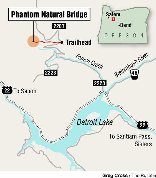
With summer showing its first sign of weakness, I headed out in search of said arch last Friday. It was a cool morning, and the hills and valleys en route took on a mystical look as I crested Santiam Pass and descended toward Detroit and the Breitenbush River. The trailhead for the hike is off a couple of logging roads, just on the west of the river’s bridge on state Highway 22.
The first, Forest Road 2223, is paved. The second, Forest Road 2207, is not. It’s rough with precipitous drop-offs to the right. I was following directions from hiking guru and author William Sullivan, as listed in the his “100 Hikes in Central Oregon” guidebook. I was to follow 2207 for about 3.7 miles, keeping an eye out for a hiker sign on the left side of the road. Now, I imagine that Sullivan has driven quite a few treacherous roads in his day, but I had trouble keeping my eye on anything but the road in front of me.
Eventually I realized I had gone too far and turned around, still looking for the elusive hiker sign now to my right. Checking the odometer, I backtracked the mile and a half I figured I had overshot it by, finding a turnout with a trail register on the left side. That trailhead was closed due to a fire, but a posted map showed my trail veering off directly across the road. I collected my essentials, locked the car and crossed over to the other side. Sure enough, there, lying in a ditch at the side of the road, was the hiker sign. (On my odometer, it is about 3.6 miles up 2207. The parking area on the right is hard to miss.)
Phantom Bridge is about 600 vertical feet above the trailhead, but the total elevation gain for the hike is listed at 1,400 feet. The trail undulates for the first 2 miles, finishing with a steep climb in the final quarter mile.
The route starts out in a forest, then traverses a slope below Dog Rock. About a mile in, you’ll pass a series of rocky outcroppings that, when skies are clear, probably offer a pretty nice view of the Opal Creek Wilderness. The first outcropping is more of a scramble, requiring a bit of dexterity to overcome. Continue down the trail a bit and there are viewpoints that are easier to reach.
The route passes tiny Cedar Lake, and then crosses an open area where rock cairns mark the route. Parts of the trail are bit tricky, particularly when descending on loose rock and sand. Eventually, you’ll reach a parking area at the end of Forest Road 2223, prompting you to wonder why you just hiked 2 miles to get here. But hey, that’s part of the fun, right?
Trending
From the parking area, it’s about 0.3 miles to the arch, climbing fairly steeply. Again, the guidebook said to look for a Phantom Bridge sign on the main trail. Apparently it’s a phantom sign as well. There is a rock cairn that marks the spot where you leave the trail onto a faint path. From there it’s only about 50 feet to the arch.
During the hike, I kept thinking about how the guidebook said a few “daring souls” walk out onto the arch. I kept telling myself there was no point in taking any unnecessary risks. After all, it was only three years ago that Wall Arch in Utah’s Arches National Park collapsed. And the Old Man of the Mountain rock formation had been around for so long, it was the image chosen for the New Hampshire state quarter. Yet, the old man came tumbling down in 2003.
I had also spent much of the hike thinking about recent changes in my own life, how quickly something that seemed rock solid could come crumbling down. I had taken stability for granted and was having trouble reconciling myself with the impending upheaval in my life.
But as I took the final steps up the slope and the arch came into view, my excitement was palpable. I set up my camera on its longest timer setting and carefully picked my way up to the rock bridge. I got as far across as I could before hearing the camera’s beeping heart rate quicken.
The arch was solid as, well, a rock. The bridge is about three feet wide at its narrowest, but it slopes a bit on the far side. I’ve been on narrower mountain ridges before, but at least there was always solid ground beneath me. On Phantom Bridge, I had solid air to the right, to the left, and below. It’s a unique experience.
So was turning around mid-bridge. But I did my best Mary Lou Retton impression and stepped back off the arch with a perfect dismount.
I’m not sure what it is about danger and risk that gets your adrenalin going and makes you feel euphoric afterward. But braving the bridge underscored a notion I’ve always known but seemed to have forgotten lately. Sometimes you don’t get what you want out of life or love or work without taking a few risks, without venturing outside of your comfort zone. There’s safety in stability and routine, but there’s also stagnation.
Sometimes, you just have to take the leap of faith, and step out onto a Phantom Bridge.
If you go
Getting there: From Sisters, drive west on U.S. Highway 20, and continue west on state Highway 22 past Detroit. On the west side of the Breitenbush River bridge, turn right onto Forest Road 2223 (French Creek Road). After 4.2 miles, turn onto unpaved Forest Road 2207 for 3.6 miles. Turn into parking area on the right. The trail starts on the opposite side of the road.
Difficulty: Strenuous
Cost: Free
Contact: Willamette National Forest, Detroit Ranger District, 503-854-3366
Marketplace


Enter the $5,000 Sweepstakes

-
eEdition

-

-