Whychus Canyon Preserve entices
Published 4:00 am Thursday, November 17, 2011
- The preserve covers some 450 acres and is targeted for restoration and trail development.
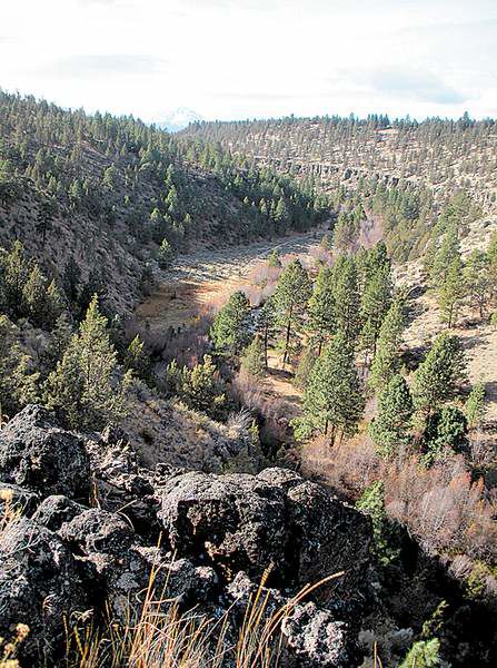
After a mellow mile and a half of wandering through open meadows and stands of gnarly old-growth junipers, the path that parallels the southern edge of the Whychus Canyon Preserve leads to a jaw-dropping, expansive viewpoint.
From the viewpoint on the rim, the canyon tumbles down to Whychus Creek. Upstream, or westward, snow-covered North Sister emerges from the forest beyond the canyon. Downstream to the northeast, we can see grassland meadows bordered by cave-pocked rock walls.
Trending
It would be a stunning spot to eat lunch, but my mom, who joined me on this outing, wasn’t interested in sitting in the blast zone of freezing wind whipping down the canyon. Like the creek, the wind came straight from the glaciers in the Three Sisters Wilderness.
The trail leading to the viewpoint, an old road, sits far enough off the rim that it lacks creek views most of the way. An adventurous explorer armed with a keen sense of place or a map and compass could scramble down into the canyon from different points along the edge, but wear sturdy boots and expect a steep, rocky hike.
If I come back to the Whychus Canyon Preserve, I will try a loop hike by scrambling down the bank to walk along the creek for one half of the loop. But last week, we opted for an out-and-back trek along the edge of the 450-acre preserve, for what I’m guessing was about a four-mile hike, including a few short side explorations to look for views into the canyon. In the morning hours when we wandered, we saw no one else.
The preserve straddles about two miles of Whychus Creek, just downstream (northeast) of Sisters. Owned by the Deschutes Land Trust, the land is targeted for restoration and trail development, but at this point trail signs are lacking. To get to the viewpoint the way we did it, (see “If you go”) start at the trailhead kiosk and walk to the right until you come to an opening in a gate across the road. The path is closed to vehicles but is easy to identify as a former road. These trails should be accessible until serious snowfall reaches low elevations.
Some laminated paper signs indicate when you pass in and out of the preserve boundary, and at one point, on federal Bureau of Land Management property, there’s a tangle of old roads where it’d be easy to lose the path. (The road to follow is slightly to the right, or the east.) The road starts to lose elevation, crosses back onto preserve land, and soon abuts a huge volcanic rocky outcropping on the left, worth climbing on for a view.
Back on the path, just past the rocky outcropping, the trail wraps around behind the rocks, closer to the creek. The open spot would be an amazing place to pitch a tent if camping were allowed, but it’s not. Other rules for this land: no horses, bikes or motorized vehicles. No hunting. Dogs must be on leash. Catch-and-release fishing allowed with barbless hooks only.
Trending
My mom and I also explored past the viewpoint to the northeast a bit further, on BLM land where the path leads down to the creek and my dog could take a dip in the water. From this low-lying point along the creek, we could see some intriguing canyons on the rock walls across the grassy meadow, but the creek was far too cold and swift to even consider fording last weekend.
Instead, mom and I called it a day, walked back out and hit the Bendistillery tasting room on Pinehurst Road, on the road back to Bend. The views of the mountains from this tasting room are also stunning, and the indoor temperatures more to my mother’s liking. The samplings of vodka and gin were also far superior to the peanut butter and jelly sandwiches we ate along the trail.
If you go
Getting there: From Bend, drive northwest on U.S. Highway 20 for about 13 miles. Turn north on Fryrear Road and continue 5.5 miles to the intersection with state Highway 126. Turn left on Highway 126, travel 1 mile, then turn right on Goodrich Road.
Follow Goodrich Road for about 1.5 miles until the paved road turns sharply right, but keep going straight at the curve and follow the gravel road about 1.3 miles. Continue going straight where a sign says “Turin.” Keep going straight north for another .4 mile to the trailhead signs. Park and walk .3 miles down the dirt road to the right, entering the preserve at the gate.
Difficulty: Easy if you take the old road as described in this story, difficult if you choose to scramble down the canyon.
Cost: Free
Contact: www.deschuteslandtrust.org; 541-330-0017
Marketplace


-
eEdition

-

-