Turkey Monster impresses
Published 4:00 am Thursday, November 24, 2011
- Turkey Monster impresses
I’m sure you’ve heard of the Easter Bunny, maybe even the Great Pumpkin. But how about the Turkey Monster?
If you’re picturing a gargantuan gobbler spewing stuffing and spreading extreme sleepiness and indigestion to his innocent victims, you’re way off. The Turkey Monster is much scarier.
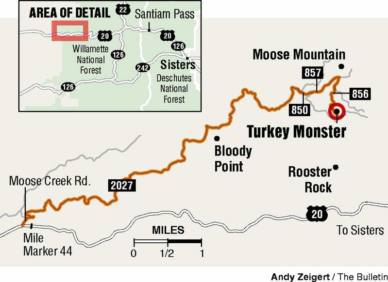
It’s a 350-foot-high pinnacle hidden in Oregon’s Menagerie Wilderness just outside of Sweet Home. With Thanksgiving approaching, it was time to track down and — armed with a camera — shoot this foul beast.
As you might expect, the Turkey Monster is not easily found. He’s definitely not a free-range turkey strolling around a fenced-in field. There’s no easy-to-follow trail to the rock pinnacle, so I was following directions I found on the climbing website SummitPost.org.
Negotiating the forest roads to approach this monster’s habitat is half the challenge. There’s active logging going on in the region, which I found out the hard way driving up the one-lane, curvy dirt road known as Forest Road 2027. Despite numerous blind corners, I encountered and avoided not one but two fully loaded logging trucks barreling down the road.
After about 8 miles of white-knuckle driving, I passed the point where the trucks turned off and had only the precipice on the far side of the road to worry about. At the 10-mile mark, I turned on Forest Road 850, which was a little rougher but still passable for passenger vehicles. It wasn’t more than another half mile before I hit a section of road covered in snow. It wasn’t deep by any means, but had frozen over and I wasn’t sure my little red Hyundai was up to the challenge.
Fortunately, my hiking boots were. I hiked the final half mile to Forest Road 856 and then 200 feet to a dead-end overlook.
A wilderness bulletin board marks the start of a rugged trail that drops about a half mile to another overgrown forest road. To find the Turkey Monster, turn left on the road and follow it about a half-mile. After you pass a campsite with a fire ring, you’ll come upon the remains of a landslide that partially blocks the road.
It’s here that the route gets tricky. The monster is about 300 feet straight down the overgrown slope from the road. Bushwhack your way down, finding the path of least resistance. There are some sections where you can see that others have passed, but there’s no clear route down. The slope is steep and covered with clumps of grass that require careful foot placement to avoid turning an ankle.
About 200 feet downslope, the vegetation opens up a bit and the Turkey Monster comes into view. There are several large rock outcroppings directly across from the pinnacle that provide a good viewing platform. I scrambled to the edge of the nearest outcropping, treading carefully to avoid being the beast’s next victim.
Turkey Monster is indeed an impressive sight. The top of the pinnacle clearly resembles a turkey head and the column tapers at the bottom, calling in question the stability of the entire structure. Talented rock climbers scale the beast, and you might be able to see the equipment they leave behind after rappeling off the pinnacle. For those of you familiar with climbing ratings, the easiest route is rated 5.11 and well above my meager climbing skills.
The Menagerie Wilderness is littered with such pinnacles, most of which are named after some sort of bird or animal. From the rock outcroppings in front of Turkey Monster, you can also see the aptly named Rabbit Ears on the horizon to the right.
It’s another 150 feet of treacherous downclimbing to get to the base of Turkey Monster. I had brought a rope in case I wanted to descend to the base, but thought better of it. I had seen the Turkey Monster in all his glory. There was no point in tempting fate.
Climbing back up the slope was slow going. Resist the urge to grab the vegetation here; it’s pretty thorny.
All told, it was less than a 4-mile round trip including the section of road hiking. From the overlook at the end of the road, it’s a descent of 500 to 600 feet to the viewing rocks.
For those of you attacking your own turkey monster today, happy Thanksgiving!
If you go
Getting there: Take U.S. Highway 20 west toward Sweet Home. Just before mile marker 44, turn right on Moose Creek Road, cross the bridge and continue onto Forest Road 2027. After 10 miles, turn right on Forest Road 850. Take a right at the first fork in the road onto Forest Road 857 and take the center road at the three-way fork. Keep right at the final fork to reach a dead end and a wilderness bulletin board.
Difficulty: Strenuous, involves off-trail hiking
Cost: Free. (This area is closed from Jan. 1 to July 31 to protect nesting raptors.)
Contact: Willamette National Forest, Sweet Home Ranger District, 541-367-5168.


Best of the Best of Bend 2025

-
-
-