Exploring the high desert
Published 5:00 am Thursday, July 12, 2012
The dashboard thermometer in my car registered an outside temperature of 90 degrees Sunday when my wife, Meryl Ibis, and I pulled into the Rimrock Springs Wildlife Management Area’s parking lot to start our first hike through the Crooked River National Grassland.
Temperatures hit the 96-degree mark at the Redmond Airport that day, just seven degrees away from a record the National Weather Service has had on its books since 1968. Luckily, Meryl had the sense to watch the previous night’s weather forecast rather than reruns of “Family Guy.” So we knew ahead of time we’d be hiking through the High Desert on the hottest day Central Oregon has had all year.
This meant we were prepared— we packed plenty of water, wore loose clothing, put on extra sunscreen and left our nonboot-wearing dogs at home where they could chill out in a fan-cooled room – and had a chance to enjoy the desert for what it is: a hot, dry place that, under the right circumstances, can reward you with a sense of solitude, brightly colored wildflowers and stunning mountain views.
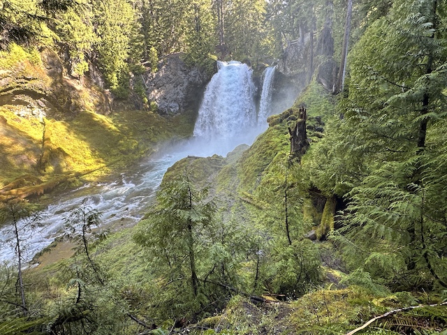
Rimrock Springs
Loosely bound by a triangle of state and federal highways connecting Madras, Prineville and Terrebonne, the Crooked River National Grassland is a 112,347-acre stretch of public land managed by the U.S. Forest Service.
It offers an array of recreational activities, including hiking, horseback riding, mountain biking and riding off-road vehicles around a series of old forest roads at Haystack Butte (See “If you go”).
Rimrock Springs Wildlife Management Area is the perfect spot to enjoy viewing wildlife, including up to 17 species of birds. It features a wetland area that grew up around a dammed spring. Access this area by hiking down a half-mile paved trail from the parking lot to a scenic viewpoint on the edge of the marsh.
We didn’t see a lot of wildlife other than a handful of birds. We did, however, see some stunning wildflowers that added splotches of red, purple and yellow to a landscape covered with sagebrush and juniper trees. The only problem was that the rocky, cracked layer of 6,700-year-old volcanic soil the flowers sprang out of was too hot and burned my knees any time I tried to get close enough for a picture.
Once you get to the marsh, you can take the paved trail back to the parking lot. Or follow a 1.4-mile-long dirt trail that takes you past another viewpoint in the wetlands and a rocky outcropping where you can see a few Cascade mountains – Mount Bachelor, Broken Top, the Sisters and Mount Washington – before the dirt trail loops back to the main paved trail and the parking lot. This rocky outcropping also gives you a nice view of Gray Butte, the next place we planned to hike.
Gray Butte
From the rocky outcropping, Gray Butte seems to tower over the snow-capped Cascade Mountains that appear to its right and much farther back on the horizon. The 5,108-foot-tall cinder cone looks even more impressive when you’re driving toward it on one of three forest service roads that connect its trailhead to pavement. These roads are very steep, filled with potholes and best left to truck owners or drivers who know what they are doing.
Those daring enough to approach Gray Butte from the southeast, heading up Forest Road 5710 from where it intersects Lone Pine Road, can get a special treat because they pass the McCoin Orchard, a still-viable stand of fruit trees homesteaders Julius and Sarah McCoin planted in 1886. There is another stand of fruit trees on the north side of Gray Butte near the Cyrus Horse Camp on Forest Road 5750.
The 7.5-mile-long Gray Butte trail, which starts at a small parking area just past McCoin Orchard, doesn’t take you to the actual summit of Gray Butte, but instead follows a ridgeline about half or two-thirds of the way up before heading down a canyon to Smith Rock. There is a set of tire tracks you can follow straight up to the summit but I’d recommend against trying this climb. It’s pretty steep.
About two miles from the trailhead is a rock outcropping that bears a memorial for someone who played an instrumental role in building the trail. But Meryl and I never made it that far because we really started to feel the sun’s heat beat down on us along the ridge, where there was even less shade than there was at Rimrock Springs. We turned back once we got near a utility pole with a good view of the Cascades.
It’s at this point that one fatal flaw in our preparations got the best of us. Well, to be honest, it got the best of me. While we made sure to pack three quarts of water in the backpack, we left my allergy medication in the backseat of my car.
Without it, I became so stuffy as we entered our second hour of hiking through a juniper forest and I was breathing so much through my mouth it was hard for me to say, “OK, I’m happy we’ve made it this far along the ridge. We can turn around now.”
But then, right about the time the heat, the dust and the pollen were getting to me, I spotted the back end of Smith Rock on the other side of some juniper trees and pushed myself just a little bit farther up the butte to check it out.
If you go
Getting there: To get to Rimrock Springs Wildlife Management Area, take U.S. Highway 97 north from Bend to Terrebonne. Make a right turn onto Smith Rock Way, which is marked by signs for Smith Rock State Park. Turn left onto Lone Pine Road and turn left again on U.S. Highway 26. The Rimrock Springs trailhead and parking area is hidden behind a rock outcropping about four miles north of this intersection.
From here, you can get to the Gray Butte Trail by heading back down U.S. Highway 26 to Lone Pine Road and turning right when you see a sign for the Gray Butte Trailhead/Skull Hollow Campground. Drive or walk down this road until you pass the McCoin Orchard. The trailhead will be to your left.
Cost: Free
Contact: www.fs.usda.gov/ centraloregon/ or 541-475-9272


Best of the Best of Bend 2025

-
-
-