Snow expected at Mount Bachelor
Published 5:00 am Tuesday, September 24, 2013
- Courtesy National Weather Service
A blast of cold Alaskan air is expected to bring snowfall early this week to Mount Bachelor and surrounding peaks in Central Oregon.
Some snow may have already fallen overnight, when the snow level was at about 7,000 feet, but more should fall today and Wednesday, said G.K. Hepburn, a meteorologist with the National Weather Service in Pendleton. The cold front, coming from the Gulf of Alaska, should lower the snow level to 5,000 feet.
Trending
“As the snow level drops over the mountains, any showers they get will be snow,” he said.
Mount Bachelor’s summit is at 9,065 feet, and the lowest lift at the Mt. Bachelor ski area starts at 5,700 feet.
The same weather system could also bring rain to Bend, according to the Weather Service, most likely on Wednesday. The low temperature in Bend could also hit freezing later this week.
The recent cooler, wetter weather in Central Oregon prompted the U.S. Forest Service and the Bureau of Land Management Monday to drop to their lowest levels fire restrictions for loggers and other people working in the woods. The restrictions cover the Deschutes and Ochoco national forests, the Crooked River National Grassland and the BLM Prineville District. The restrictions remain in effect until the end of October, no matter the weather.
Summer ended over the weekend, but it is early for the Cascades in Central Oregon to be getting snowfall, according to Kathie Dello, deputy director of the Oregon Climate Service in Corvallis.
“The second week of October … is usually when we’d start to expect snow to start falling in the Central Oregon Cascades (on average), but it can happen earlier or later,” she wrote in an email.
Trending
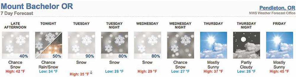
The Weather Service forecast called for about 4 to 9 inches of snow to fall on Mount Bachelor between Monday afternoon and Wednesday night. During the snowy stretch, highs on the mountain are expected to be in the mid-30s to low 40s, and lows should dip into the high 20s.
With temperatures expected to warm up later in the week, though, that snow is unlikely to last. Sunny days are in the Weather Service forecast from Thursday through Sunday, with highs gradually increasing into the lower 50s and lows gradually increasing to the low 40s.
Dello wasn’t surprised by the weeklong forecast for Mount Bachelor, with snow on one end and sunshine on the other.
“Definitely fall in Oregon,” she said.
As of Monday there weren’t any measurable amounts of snow on the ground at any of the automated sites around the state maintained by the Natural Resources Conservation Service, said Melissa Webb, a snow hydrologist for the agency in Portland. But that doesn’t mean there aren’t mountaintops with dustings of snow.
“We don’t have sites that are up above treeline,” she said.
Those sites often receive teases of snow through October, Webb said, with snow falling and then melting away. Eventually during fall, the snow starts sticking for good in the mountains.
It is unclear whether the early dropping of snow this week is an indicator of a snow-heavy fall and winter. A seasonal climate forecast for October to December complied late last week by Pete Parsons, Oregon Department of Forestry meteorologist, though, does call for “ample mountain snow.”
Marketplace


Best of the Best of Bend 2025

-
eEdition

-

-