Portland’s Forest Park trails beckon hikers, bikers
Published 12:00 am Wednesday, January 22, 2014
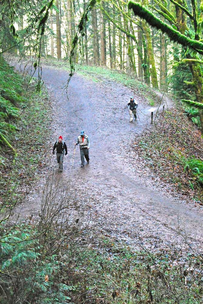
- Photos by Tom Paulu / The Daily NewsHikers in Forest Park cross one of the wider routes where mountain bikes are also allowed.
PORTLAND — Here is one trail system where you are guaranteed to get cellphone reception should an emergency occur.
Forest Park is within the Portland city limits, and no place in the park is more than a few miles from a cellphone tower. But this is a place where phones are best left turned off to accentuate the truly wild nature of the hiking and mountain-biking trails.
Despite its urban surroundings, Forest Park’s inner reaches can seem remote indeed, with trails winding through fir and maple forests past slopes carpeted with ferns.
“It’s the largest forested urban park in the lower 48 states,” said Renee Myers, executive director of the Forest Park Conservancy, which advocates for the park and helps with maintenance. “It’s amazing that it’s right on the edge of an urban city.”
With its 70 miles of trails, the 5,100-acre Forest Park offers by far the most extensive trail system within a one-hour drive from the Longview-Kelso area.
Recently, my 12-year-old daughter and I joined a group of 15 hikers from the Longview/Kelso-based Mount St. Helens Club for a brisk 8-mile hike.
Hike leader Bruce McCredie, the group’s president, chose the Maple Trail, which is one of the more remote trails in the middle of Forest Park.
“It’s close to Longview,” McCredie said of the trail. “It’s low-elevation,” and thus a good winter hike, he added. “You’re 2 miles from Portland’s industrial area. You get in there and you can’t even hear it anymore,” he said.
The hike started at the end of Lower Saltzman Road, a narrow road that climbs steeply from Highway 30 in Portland’s industrial area. (Warning: Mobile navigation apps may direct you to Upper Saltzman Road, which feeds into a different part of the trail system).
McCredie led the group away from the parking area and into the woods. “When you get to the junction, you have to wait so we all stay together,” he suggested. That didn’t always happen with this spirited group of hikers, though group leaders communicated on portable radios to make sure no one took a wrong turn. (Warning: The many intertwined trails in Forest Park are well-marked, but having a map or experienced leader is a good idea.)
The Maple Trail links to the Wildwood Trail, the primary hikers-only route that meanders from one end of the park to the other. The 30-mile-long Wildwood Trail is marked with blue diamonds painted on trees, similar to the system of plastic markers used for winter-season trails in national forests. The Maple and Wildwood trails are mostly in good condition, though there are a few stretches of slippery mud even after a period of relatively little rain.
After a couple of hours of hiking, the Mount St. Helens Club group stopped for a hasty standing lunch — the ground was too damp for pleasant sitting. We didn’t see many other walkers, though joggers occasionally trotted past. According to a 2010 survey of park users, 38 percent came for hiking, 25 percent for running, 14 percent for walking dogs and 8 percent for cycling.
The trails zig and zag so much that it’s hard to remember in which direction the city lies — though, from time to time, the rumble of a train in the distance is a clue.
After about three hours on the trail, the hikers returned to their vehicles and split up, some heading back to Longview and others to Portland attractions.
“It’s a great trail,” said Bob Baldwin, an 82-year-old retired forester who’s spent many a day in the woods. “I was wondering if I was going to be able to make it, but it wasn’t a big deal,” Baldwin said.
Myers said the Wildwood Trail is the most popular route in the park and the one she recommends most.
Another popular trail that’s relatively easy is the Lower Macleay Trail, which climbs 1.4 miles to the Portland Audubon Society building. From there, it’s another mile by trail to the Pittock Mansion.
Mountain bikes aren’t allowed on the trails we hiked, though they are allowed in other areas. A particular favorite for cyclists is Leif Erickson Drive, an 11-mile route once used for vehicle traffic. There also are numerous unpaved fire lanes that are closed to motorized vehicles but open to mountain bikes.
The Forest Park Conservancy recommends four different maps, all of which can be ordered though its website, www.forestparkconservancy.org. The maps also are available at Portland area bookstores and at REI. Near the park, maps are available at the Portland Audubon Society Nature Store at 5151 N.W. Cornell Road.


Best of the Best of Bend 2025

-
-
-