Hike to a High Desert oasis
Published 12:00 am Wednesday, May 7, 2014
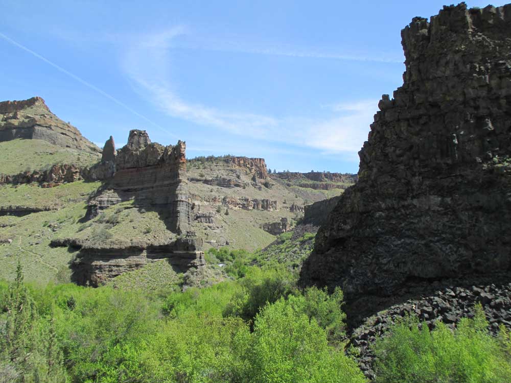
- Photos by Mark Morical / The BulletinCastlelike rock formations line the water where Whychus Creek flows into the Middle Deschutes.
• Difficult trail. Check.
• Sketchy creek crossing. Check.
• Out-of-the-way place. Check.
• Snakes. Check.
Wait, what was that last one?
Let’s just say I won’t be taking my ophidiophobic wife on this hike anytime soon.
Despite the abundance of slithering serpents along the Alder Springs Trail — rattlesnakes included — this is one springtime hike in the Central Oregon high desert not to be missed. Sweeping canyon vistas, amazingly weird but beautiful rock formations carved by time, desert oases and elusive wildlife are just a few features of this off-the-radar trail in the Crooked River National Grassland.
About a 40-mile drive from Bend, and located just northeast of Sisters, Alder Springs requires a hairy, white-knuckle drive over jagged rocks and deep potholes into the trailhead. Mine was the only car at the trailhead’s small parking area on a sunny midweek day when the temperature would top out near 70 degrees.
The signs at the kiosk warn hikers of the rugged, steep nature of the trail — which is closed to bikes and horses — and of rattlesnakes and ticks. I was up for the challenge, but I would be wary of every little rustling I heard in the grass and bushes that line the narrow trail — and I would hear a lot of rustling.
I started out on a ridge that overlooks Whychus Creek as it carves through the canyon. The trail follows the canyon for three-fourths of a mile before descending steeply into the Alder Springs side canyon.
On the trek down toward the creek, a short path leads to an area carved cylindrically out of the rock. The spot is so perfectly shaped it was like stepping into a small room. Along the walls of the “room,” hundreds of hikers have cut their names or phrases into the soft rock.
A half-mile farther down, the trail reaches Whychus Creek at Alder Springs, where snowmelt from the Cascade Range “magically” reappears after a 40-mile downhill trip, according to an informational sign at the creek. The water of Alder Springs nourishes many plants and animals not typically found in the high desert, including many migratory birds, making the location a true oasis.
After little more than an hour of hiking, I was not ready to turn back. But from where I stood, there was nowhere to go. The trail dead-ends at Whychus Creek.
Then I saw it, just sitting there like an open invitation to see what lie beyond on the other side of the creek. A yellow rope stretched across the stream and was tied securely to a tree on each bank, providing aid in fording the foot-deep creek. I removed my shoes and socks, then put my shoes back on because the creek bed was extremely rocky, and made it across pretty easily thanks to the rope.
On the other side of Whychus, I discovered more springs bubbling from out of the green grass. The singletrack trail continues back up a ridge, and it would lead me another 1½ miles to where Whychus Creek flows into the Middle Deschutes River, just south of Lake Billy Chinook.
Leaving the Alder Springs area was when the hike really got intense. The trail becomes more technical and steep there, and the sun bore down while I crested the ridge. Eventually I arrived down at a green meadow alongside the creek.
From there, the trail tightens up as long grass and thick underbrush line the path. Who knew what was lurking in there? Snakes, to be sure.The 1½ miles began to feel more like 5 miles as the trek grew laborious. And that’s when I heard it: The peaceful rushing sound from Whychus Creek became a roar.
I had finally reached the confluence with the Deschutes. Sure enough, a wooden sign nailed to a ponderosa pine read “Maintained trail ends here.”
Of course, as soon as I read that, I thought, “I can keep going.” But just a few hundred feet farther downstream the vegetation had grown too thick and the trail disappeared. I headed back to the sign and walked down to the river’s edge, where smooth, flat rocks provide a perfect spot to rest as the surging blue water of the Deschutes swirled around me; another type of oasis.
The unique canyon walls above display layers of rock of various colors — and one section of the wall includes spirelike formations like some sort of medieval castle.
As I gazed at the river and the canyon, a large-winged insect flew straight into my face. Taking a quick glance at the ground and into the air, I saw dozens of black and yellow butterflies. A later Google search indicated that these were Oregon swallowtail butterflies, which live in the sagebrush canyons of the Columbia River and its tributaries, according to the Oregon Department of Fish and Wildlife. The swallowtail was designated as Oregon’s official state insect in 1979.
The wildlife sightings continued on my trip back, when I finally saw a couple of snakes. The first was a common garter snake, and the second moved too quickly into the bushes for me to identify — though I was happy to note that it was not rattling.
The 6-mile round trip required about 4½ hours on the rocky, slow-going trail, but the Alder Springs hike is a Central Oregon spring gem despite the difficulty — and despite the constant rustling in the grass.
— Reporter: 541-383-0318, mmorical@bendbulletin.com


Best of the Best of Bend 2025

-
-
-