Travel: Oregon wilderness areas
Published 12:00 am Sunday, September 7, 2014
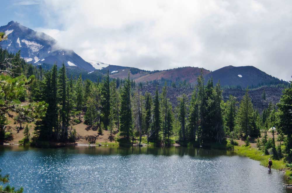
- Bulletin file photo9. South Matthieu Lake - Found just off the Pacific Crest Trail.
BREITENBUSH — When all the huffing and puffing was done, we found ourselves in a little piece of paradise. And wasn’t that what the effort was all about?
Certainly, no one ever said our day hike into the Mount Jefferson Wilderness Area would be easy. From a starting elevation of 3,100 feet, just above Breitenbush Hot Springs, we climbed steadily over nearly 6 miles to about 6,000 feet. It may not have been strenuous for younger, more athletic outdoors lovers, but for hikers such as ourselves — approaching our senior years, minds willing but bodies not entirely in agreement — it was a grind.
Trending
Our destination was Jefferson Park, a region of alpine meadows beneath the dramatic northwestern slope of Oregon’s second largest peak, Mount Jefferson. Rising 10,497 feet in the heart of the Cascade Range, the ancient volcanic summit presented a late-summer face of stark gray basalt punctuated by thick glaciers, their crevasses rippling like a bodybuilder’s muscles.
{%TravelWild-p01 090714%}
We fell just short of our goal, running out of gas after cresting a spruce-covered ridge about a mile short of Russell Lake, where the South Breitenbush Trail meets the Pacific Crest Trail. We stopped to lunch and recharge beside a tiny alpine tarn, the surrounding meadow an emerald green, the dramatic mountain framed by subalpine fir and almost near enough to touch.
Our “dogs” were barking — to put it another way, our feet hurt — as we retraced our steps and descended the way we had come in. Cobbles of loose rock that had barely been noticeable in the morning now hobbled our return walk. Huckleberry bushes and beargrass gave way to thickets of Oregon grape as we crossed several spring-fed streams, finally reaching the springy forest floor in the last mile before the trailhead.
Some readers may wonder: Why? Why should we venture onto a little-traveled path — in eight hours, we encountered only seven other human beings and two dogs, and we were by far the oldest, even when measured in dog years — just to find physical discomfort along with the possibility of a bear encounter?
The answer, in one word, is wilderness.
Trending
50 years ago
Now, I am not one likely to disappear for months “Into the Wild,” like the young man in a recent movie. But I am eternally grateful that substantial swaths of national forest and rangeland have been preserved by our federal lawmakers as places to be forever excluded from development, whether that means loggers’ saws or tourists’ vehicles.
My spirit is renewed by my occasional visits to lands where I smell cedar boughs, not exhaust fumes; where I hear the chatter of woodpeckers, not the slamming of doors; and where my vision is filled by mountains and lakes, not by concrete and blacktop.
The best thing about wilderness is this: You can’t drive there.
It was 50 years ago this week, on Sept. 3, 1964, that President Lyndon B. Johnson put his signature on the Wilderness Act and established a legal definition for these lands: “A wilderness, in contrast with those areas where man and his own works dominate the landscape, is hereby recognized as an area where the earth and its community of life are untrammeled by man, where man himself is a visitor who does not remain.”
{%TravelWild-p02 090714%}
Initially, the law protected 9.1 million acres (more than 14,000 square miles) of national forest. But it also created the National Wilderness Preservation System, which over a half-century has expanded wilderness acreage to 109.5 million acres (171,000 square miles) in 44 states and the territory of Puerto Rico — about 5 percent of all land in the United States.
In Oregon today, there are 47 wilderness areas totaling 2.6 million acres (more than 4,000 square miles). The two largest are the Eagle Cap Wilderness Area, in the Wallowa Mountains, with 350,000 acres, and the Three Sisters Wilderness Area, just west of Bend, with 286,000 acres. Both were among the original nine designated wildernesses in this state. While most of Oregon’s wilderness areas remain part of the National Forest system, eight of them are wholly or partly administered by the Bureau of Land Management, while two coastal reserves are maintained by the U.S. Department of Fish and Wildlife.
Three Sisters hike
Given its proximity to Bend, less than 15 miles away, it’s no surprise that the Three Sisters Wilderness gets more use by Central Oregon residents than any other. Stretching from McKenzie Pass south to Waldo Lake, from Broken Top to the upper McKenzie River, this designated wilderness is accessible from any number of trailheads and parking areas just off the Cascade Lakes Highway and other roads.
We used McKenzie Pass as our access point on a 5-mile August day hike into the Matthieu Lakes. As opposed to our walk to Jefferson Park, this trail was exceedingly well trodden: For most of the route, we followed a section of the Pacific Crest Trail (PCT), the foot-travel freeway that runs 2,663 miles from Mexico to Canada, much of it through alpine wilderness.
Several backpackers with whom we spoke along the trail told us stories of their trek, how they were grateful for a mild spring in California’s High Sierra, how they planned to complete a six-month journey just across the British Columbia border in mid-October. Some were teen-agers. Most were in the 20s and 30s. Some of them were covering more than 20 miles a day.
{%TravelWild-p04 090714%}
We were quite happy with our easily accomplished, 5-mile goal — a couple of miles of relatively level path, from the Lava Camp Lake trailhead to North Matthieu Lake, then a somewhat steep but blessedly short ascent to smaller South Matthieu Lake. We returned to our starting point via the PCT, along a ridgeline that offered a bird’s-eye view of North Matthieu and a northward-looking panorama of every major Cascade peak from Mount Washington to Mount Hood.
At North Matthieu, which is about twice as long (maybe a quarter-mile) as it is wide, we encountered a man of about my age teaching his pre-teen grandson how to fish. The pair were casting their lines for brook trout, and perhaps inevitably, the youngster managed to hook a log. But the boy was pleased to share that the brookie they had caught in the early-morning hours had been a tasty addition to breakfast in their mountain hemlock-enshrouded campsite.
The North Sister made its presence more unmistakably known at tiny South Matthieu. Not much larger (or so it seemed) than a rodeo arena, the pool nevertheless reflected the towering mountain in waters glazed with crystal-like sunlight.
{%TravelWild-p03 090714%}
Northeastern Oregon
One of my fondest wilderness memories came a few years ago, in back-to-back rafting and horse-packing trips through Hells Canyon and the Wallowas, demonstrating that there are other, non-motorized ways to explore American wilderness other than on foot.
Straddling the Snake River on the border of Oregon and Idaho, Hells Canyon lays claim to being the deepest river-carved gorge in North America. Falling 7,913 feet from the high point of Idaho’s Seven Devils Mountain to the canyon floor at Granite Creek, it is a couple of thousand feet deeper than Arizona’s more colorful Grand Canyon.
On both sides of the northbound Snake, basalt cliffs rise in steps above the river. Here and there are gravel bars and alluvial streams, where Nez Perce Indians once wintered and pioneer homesteaders built remote cabins and orchards.
We put our vessels into the river just below the Hells Canyon Dam. For four days, our party of nine, including three guides, voyaged 51 miles in a pair of large rubber rafts. We braved huge whitewater rapids and other hazards, but were rewarded with spectacular scenery and a heaping helping of camaraderie.
Day Two was the most challenging on this great river: It brought a pair of dangerous Class IV rapids. Wild Sheep is the longest rapid on the entire 1,040-mile Snake River, which rises in Wyoming and meets the Columbia River near Washington’s Tri-Cities. Granite Rapids featured the notorious “Green Room.” “When we were in there,” said fellow rafter Dennis Cornwell, “all I could see was green. But then I saw that my knuckles had turned white.”
On Day Three, we sighted a herd of bighorn sheep: 15 rams, ewes and lambs climbing the vertical cliffs. Our campsite at Tryon Creek offered marvelous river views along with a glen of poison oak, a nest of rattlesnakes and a major thunderstorm. The following day, we left the river at the point where Chief Joseph led his tribe across the flooding Snake into Idaho at the start of the Nez Perce War in 1877. What marvelous wilderness this was.
But there was more to come, on a three-day ride through the beautiful Eagle Cap Wilderness. From the head of the Lostine River Valley, we set out in a procession of 14 horses, half of them pack animals. It took three hours to negotiate the narrow 7½-mile track to our mountain camp. Beginning at 4,000 feet, we climbed through a forest of spruce, hemlock and Douglas fir to an alpine meadow where short grasses, wildflowers and subalpine firs were the predominant vegetation. We set up camp around 7,500 feet.
{%TravelWild-p10 090714%}
Vestiges of winter snowfall clung to north-facing mountain slopes. The broad meadows, small lakes and granite peaks gave the region a Sierra Nevada flavor, quite different from the ponderosa forests and stark volcanism of the Cascades. Above us loomed majestic Eagle Cap, the 9,572-foot crown jewel of this wilderness.
In the morning, we saddled up for a ride deeper into the preserve. Our destination was the Lakes Basin, its 20 immaculate lakes scattered between the various high peaks on the northeastern flank of Eagle Cap. Past lovely Mirror Lake, reflecting the mountain scenery in its glistening waters, we descended to Moccasin Lake, where we dismounted to enjoy lunch on a picture-perfect Wallowa Mountain day.
South and beyond
Two other favorite wilderness destinations are in southwestern Oregon.
Adjacent to Crater Lake National Park on its south side, and extending nearly to the Lake of the Woods resort complex, the Sky Lakes Wilderness Area is renowned for the purity of its mountain lakes. Some 27 miles long and 6 miles wide, it includes a pumice desert on its north end and Mount McLoughlin, southern Oregon’s highest peak (9,495 feet) in the south. The summit towers above manmade Fourmile Lake, from which trailheads climb into the wilderness and connect with the PCT.
{%TravelWild-p11 090714%}
To the west is the Wild Rogue Wilderness, embracing an 84-mile stretch of the Rogue River designated as “wild and scenic.” It’s an exception to the usual wilderness area, as rustic lodges have been grandfathered into the designation, along with limited operation of commercial jet boats on the lower portion of the river.
Visitors may explore the Rogue, its rocky bluffs and its adjacent fir-cloaked hills by a trail that trace the river’s banks, or undertake a multi-day rafting trip. The latter often make overnight stops at the aforementioned lodges, where full dinners and breakfasts add a touch of luxury. Both hikers and rafters report that black bears are common in these woods: I’ve seen them myself along the Rogue River.
{%TravelWild-p13 090714%}
Not all wildernesses are in forested or mountainous areas. Nearest to Bend of any wilderness area (a mere 10 miles, to its nearest edge, via U.S. Highway 20) is the Oregon Badlands Wilderness, between Alfalfa and Horse Ridge Summit. This 29,000-acre BLM-managed preserve was set aside just five years ago, but it has become known for trails through its juniper-and-sage landscape, for its dry river canyons and castle-like rock formations.
In the southeastern part of the state, the sprawling Steens Mountain Wilderness, established in 2000, climbs from the Malheur National Wildlife Refuge to the 9,733-foot summit of the largest fault-block mountain in North America. Climbing through eight distinct ecological zones, this wilderness area does allow motorized vehicles, so long as they remain on a single gravel road that loops through the preserve. Visitors can expect to see bighorn sheep, elk, pronghorn and perhaps a herd of the fabled Kiger wild horses in a northern valley.
{%TravelWild-p16 090714%}
For me, I am pleased to spend time in any and all of these uninhabited places. Like the boy in Maurice Sendak’s popular children’s book, I will continue to go “Where the Wild Things Are” as long as I can travel on my own two feet.
— Reporter: janderson@bendbulletin.com.
Marketplace


Best of the Best of Bend 2025

-
eEdition

-

-