Travel: Steens Mountain and beyond
Published 12:00 am Sunday, October 12, 2014
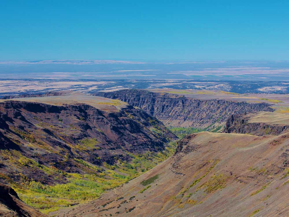
- Barb Gonzalez / For The BulletinThe Little Blitzen Canyon, contained within the Steens Mountain Wilderness, is one of several broad glacial gorges that sweep off the 9,733-foot mountain. In autumn, the leaves of aspen surrounding the headwaters of the Blitzen River turn shades of yellow and orange.
FRENCHGLEN — Steens Mountain isn’t like other mountains. Identified as the largest fault-block mountain in North America, this singular summit extends from south to north for 30 miles, and rises more than a mile above the surrounding desert landscape.
Located a four-hour drive from Bend in southeastern Oregon, 9,733-foot Steens Mountain is at the heart of an arid region that is known, quite simply, as “The Steens Country.”
Trending
That includes the alkaline Alvord Desert beneath the eastern flank of the mountain; the marshy Malheur National Wildlife Refuge to its north and west; and the wildlife-rich Hart Mountain National Antelope Refuge farther to the west. It also contains the tiny oasis of Frenchglen, where the principal road to the summit of the Steens begins, and the historic ranching community of Diamond at the foot of the Kiger Gorge, whose herds of wild mustangs are famed near and far.
These are all worthy sights. But Steens Mountain itself is the highlight.]
{%TravSteens-p01 101214%}
The massive landform, long the focus of a political tug of war between open-range advocates and wilderness lovers, is taller than Mount Bachelor and almost as high as the Three Sisters.
The 58-mile loop road to the mountaintop is deceiving. From the west, it rises at such a gentle slope that it’s hard to picture an ascent of 5,500 feet. Yet the graded gravel road climbs through eight different vegetation zones, from riparian wetland through juniper and pine woods to sage-covered prairie and finally subalpine tundra.
The summit reveals a face dramatically different than the incline. A series of broad gorges, their floors painted in autumn with the yellows and reds of spindly aspens, dive through steep walls to the west and north. And the east rim of the Steens is even more spectacular: The ivory-white Alvord Desert is a full mile below barren crags, bearing mute testimony to the forces of geology that lifted this mountainous block from the earth’s crust as the Rocky Mountains and Cascade Range were being pulled apart millions of years ago.
Trending
{%TravSteens-p07 101214%}
From Frenchglen
We arrived on a Wednesday evening at the Frenchglen Hotel, an eight-room inn 60 miles south of Burns on state Highway 205. Shared bathrooms were installed in the late 1930s, but otherwise its bones are the same as when it was built in 1916. Presently it is getting a cosmetic makeover with a new roof and fresh paint, as an Oregon State Heritage Site should have.
{%TravSteens-p02 101214%}
The rooms are tiny and basic. There are no phones, no TVs, no internet access. No one locks their doors; in fact, guests are not even offered keys. The staircase to the second floor is narrow enough to raise questions about fire safety. (There are emergency exits.) But the family-style meals are wonderful and filling (you must reserve ahead for dinner), and there is great camaraderie among guests, birders and elk hunters alike.
Bend native John Ross, 53, once a teen-aged ski racer at Mt. Bachelor, has managed the Frenchglen Hotel for 23 years. He’s one of 11 people who call the hamlet home between March 15 and November 1, when the hotel closes for the season. That’s when Ross departs the desert to travel and enjoy a few breaths of city life.
Other times, however, he’s here at the foot of Steens Mountain, named in 1860 for Army surveyor Major Enoch Steen.
The Steens Loop Road begins directly opposite the hotel, off Highway 205. Climbing to within a short hike of the summit, it is contained within the Bureau of Land Management-administered Steens Mountain Cooperative Management and Protection Area, an open rangeland that cattle share with varied wildlife. Much of the adjacent roadless terrain is the federally designated Steens Mountain Wilderness.
{%TravSteens-p09 101214%}
The entire 58-mile gravel route is easily navigated by a passenger car. It wasn’t so four years ago, but the southern section of the road has since been greatly improved, especially a steep 4-mile section along Big Indian Gorge that had been deeply rutted.
We took the North Loop Road to the summit, the South Loop Road back down, maintaining a speed of 35 miles per hour for most of the route. Anglers told me there is a rich bounty of rainbow and brook trout in the waters of Fish Lake, 17 miles uphill at 7,500 feet elevation. A short distance further, the Jackman Park campground nestles in an aspen grove.
A few miles from the top of the hill, Kiger Gorge Overlook affords a panoramic view of a glacial valley carved in the last Ice Age, more than 10,000 years ago. The only north-running canyon off the mountain, Kiger is best seen at midday, when the sun is high in the sky and shadows aren’t cast across its framing walls.
{%TravSteens-p06 101214%}
The vista from the East Rim Overlook, just below the summit, is even more remarkable, if that’s possible. This is the classic view of the Alvord Desert, with Mann Lake beyond.
The descent via the South Loop Road is no less vividly picturesque. Here, the route picks a path down a ridgeline between the Little Blitzen and Big Indian gorges, both of them pallets of fall color, from their scree-covered walls to their central creeks hundreds of feet below the road. The South Loop junction with Highway 205 is 10 miles south of Frenchglen.
{%TravSteens-p10 101214%}
Birds and pioneers
Malheur National Wildlife Refuge extends to Frenchglen. Established in 1908 by President Theodore Roosevelt and operated by the U.S. Fish and Wildlife Service, the refuge claims more than 320 bird species and 58 mammal species, large and small, in its 187,000 acres of habitat, which include 120,000 acres of wetlands.
More than 40 miles north, we began our refuge visit with a stop at its headquarters and small museum, 6 miles east of Highway 205 (there’s a junction at The Narrows store and gas station). Then we crossed Sodhouse Lane and turned onto the refuge’s self-guided Blitzen River Valley Auto Tour Route, a 42-mile gravel byway with 19 signs indicating recommended stops. A 20-page brochure is available at headquarters.
We saw numerous ring-necked pheasants dancing through the marsh grass, and one very prominent great horned owl that soared in front of our car and posed for photographs from the branch of a cottonwood tree.
{%TravSteens-p12 101214%}
Mule deer peered from behind the tall grasses. A coyote pounced in the near distance, perhaps cornering a tiny shrew; varied thrushes flew from tree to tree, displaying the vermilion on the undersides of their wings.
At the southern end of the auto tour route, near Frenchglen, is the P Ranch, headquarters of rancher Pete French’s 1872-1897 cattle empire. The mercurial French, backed by a wealthy California stock grower named Hugh Glenn (thus the name “Frenchglen”), built an initial herd of 1,200 cattle to 45,000 on land holdings of more than 190,000 acres, from Steens Mountain to Malheur Lake.
French’s long barn at the P Ranch may still be visited today, as may his Sod House Ranch (near the refuge headquarters) and the Round Barn north of Diamond. Now a state heritage site, this circular barn, built around 1880, was used for sheltering horses and breaking wild mustangs during the lengthy winters.
Today the barn is located on the Jenkins Ranch, in its fourth generation of ownership by one family.
Full-day tours of Steens Country ranching heritage begin from the Round Bar Visitor Center, which incorporates a family museum. It’s about 35 miles from Frenchglen, part of it through the Diamond Craters Outstanding Natural Area — a unique volcanic region whose lava flows date from about 25,000 years ago.
Alvord Desert
The Alvord Desert, that large splash of white you saw from the top of Steens Mountain, may be reached by a 58-mile drive southeast from Frenchglen. Past the vast Roaring Springs Ranch, Highway 205 climbs over Catlow Rim, at the southern end of the Steens, and emerges in tiny Fields, 20 miles north of the Nevada border.
Fields is the home of the Fields Station, which offers three rustic rooms, an RV park, a general store and a cafe well known for its burgers and its multiple flavors of homemade milkshakes. Although the complex is for sale (asking price is $795,000), it’s likely that buyers, whomever they may be, will continue to display scores of photos of visiting hunters posing with their trophies — elk, pronghorn and bighorn sheep.
There once was a viable community at Andrews, about 10 miles north of Fields, complete with a hotel, a post office and a school. The hotel burned down in 1924. The post office, established in 1890, was closed in 1943. The Andrews School, District No. 29, never had more than a dozen students and was shuttered many years ago. But since 2011 it has been the home studio of artist John Simpkins, a former Camp Sherman and Sisters resident whose colorful and whimsical oil paintings, many featuring animals, have earned him increasing acclaim.
{%TravSteens-p15 101214%}
The Alvord Desert is a few miles further north. This chalky sheet of alkali is so hard, you can drive your car upon it. Sitting in the Steens’ rain shadow, this desert is Oregon’s driest place, averaging only 5 inches of precipitation per year. The Alvord is 11 miles long, 6 miles wide, pure white and entirely devoid of any vegetation or life form.
{%TravSteens-p16 101214%}
Yet chances are you’ll find tents pitched or RVs parked on the surface of this ancient playa. You’ll see all-terrain vehicles and dirt bikes as well as “land sailors,” hand-manufactured vehicles best described as small wheeled sailboats. When the wind is up, they streak across the alkaline surface at remarkable speeds. And when their day of play is complete, these speed lovers can clean up in primitive Alvord Hot Springs.
The springs bubble up beside the road at the foot of Steens Mountain. They are piped to several tubs covered by a simple lean-to. Recent improvements have added an office and gift shop, and made room for a semi-permanent caretaker who lives in a customized trailer home.
Hart Mountain
The road to Hart Mountain, departing Highway 205 about 8 miles south of Frenchglen, crosses the most featureless wasteland I’ve seen anywhere in Oregon. The Catlow Valley has sand, sage and nary a tree. After 37 miles of graded gravel, I was glad to get into the more undulating terrain of the Hart Mountain National Antelope Refuge.
To call this an “antelope” refuge is a misnomer. Although nearly 100 species of antelope live in Africa and Asia, there are no native antelope in the Western Hemisphere. The namesake of Hart Mountain is the pronghorn, a hoofed ruminant with a distinctive tan-and-white coat, and the last surviving member of a family of animals that thrived in North America during the time of early humans. Incorrectly labeled “antelope” by the Lewis and Clark Expedition, pronghorn are in fact more closely related to the giraffe and the okapi than to Old World antelope.
Evolved with a 320-degree field of vision and remarkable speed — the fastest land mammal in the Americas, clocked at more than 45 miles per hour over long distances — the pronghorn nonetheless found its survival threatened by hunters in the early 20th century. Its numbers, once estimated at 30 million, had been reduced to a mere 20,000 by 1908. President Roosevelt installed hunting restrictions and habitat-protection measures to help the species rebound. Today, there are well over half a million pronghorn; Hart Mountain was a key component in that recovery.
{%TravSteens-p17 101214%}
Today the refuge, which extends across 278,630 acres (435 square miles) northeast of Lakeview, has become known for much more than its pronghorn population. Forty-two different mammals live here, including bighorn sheep, elk, mule deer, cougars, coyotes and bobcats; they share the refuge with 239 species of birds, many of them migratory.
We saw dozens of pronghorn in the refuge, in herds of as many as 20 or wandering solo through the acreage. To the benefit of the animals, there are few roads with the exception of high-clearance Jeep tracks and horse trails.
At the heart of the refuge is a tiny headquarters village with residences, maintenance buildings, and a tiny museum and resource library. Here, visitors may obtain a free permit for one of the primitive campsites within the refuge boundaries. The main campground, four miles south of headquarters, has 30 designated sites beside a tiny stream adjacent to a hot spring — partially enclosed within rock walls but open to the sky. The water temperature is a constant 101 degrees.
On the west side of the refuge, the road switchbacks down the side of a cliff, offering roadside viewpoints with panoramas across the otherworldly Warner Valley.
{%TravSteens-p19 101214%}
On some of the rim rocks, ancient petroglyphs are etched into the stone, archaeological reminders of 10,000 years of human habitation of this region.
The road reenters civilization at Plush, an unincorporated community of fewer than 100 people. Central Oregon travelers may return home via U.S. Highway 395 at Lakeview, continuing on state Highway 31, the Oregon Outback Scenic Byway, from Valley Falls to La Pine.
— Reporter: janderson@bendbulletin.com
Marketplace


Best of the Best of Bend 2025

-
eEdition

-

-