10 Oregon adventures to consider in the new year
Published 12:00 am Wednesday, January 7, 2015
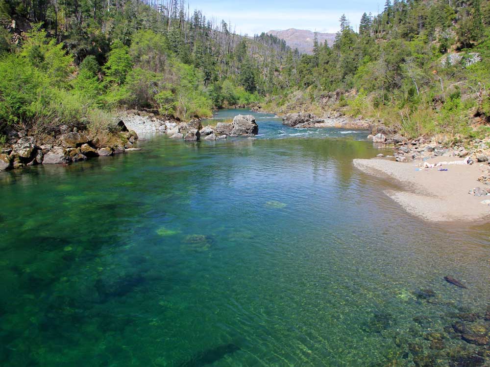
- Courtesy The (Salem) Statesman ReviewThe Illinois River Trail offers a unique place to seek rare plants and flowers.
Another year has come to a close, and with it, the arrival of a fresh season for outdoor adventure in Oregon.
But before we charge forward and begin planning all the trips we’ll take in 2015, it makes sense to take a step back and consider the places we’ve been.
This was my seventh year as an outdoor writer in the Beaver State, and what struck me most — though not for the first time — was just how many spectacular places we have at our fingertips. You could spend a lifetime exploring Oregon and not see everything.
But that doesn’t mean I won’t try.
Here are my top 10 favorite trips of 2014. Hopefully, you will find something new here, a place you never knew existed to try out in 2015.
I’ve made every effort to include all the information and links you’d need to plan a vacation to these places, but if you have questions, as always, give me a call at 503-399-6801.
No. 10: Sparks Lake
There’s a good case to be made that the most scenic flat-water paddling trip in Oregon is found at Sparks Lake.
The Central Oregon destination is what photographers dream about at night, with South Sister (10,358 feet), Broken Top (9,175) and Mount Bachelor (9,065) rising in dramatic splendor above crystal water 25 miles east of Bend.
But Sparks Lake offers more than good looks. Hop into a kayak or canoe and it’s possible to explore a labyrinth of secret passageways, hidden coves and geological oddities in a body of water more fascinating than the glossy magazine spreads might suggest.
The only downside at Sparks Lake is the crowds. Sunny weekends almost always see the boat ramp jam-packed. Once you’re on the lake, it’s not so bad as long as you’re not seeking solitude.
Canoes and kayaks are the most common boat, with stand up paddleboards a close third. The lake allows motorized boats traveling below 10 mph.
Best time to visit: May, June, July and early August (depending on conditions)
Directions: From Bend, travel 26.2 miles west on Cascade Lakes Highway and turn left at pointers for Sparks Lake on Forest Road 4600 and 400.
No. 9: Niagara Falls Trail
Despite the famous name, few people have any clue that this spectacular trail sits an hour’s drive from Salem.
In this remote box canyon in the Coast Range northwest of Willamina, a short and easy trail leads to two 100-foot waterfalls thundering next to each other: Niagara Falls and Pheasant Creek Falls.
“That you can hike this trail and not see another person is pretty special,” said J.W. Cleveland, Hebo Ranger District trails manager. “It’s a true hidden gem.”
The reason for the lack of visitors is the remote location. From Salem, you must navigate a series of sometimes-confusing county, Bureau of Land Management and Forest Service roads.
Once at the trailhead, the trail drops downhill through mossy second-growth forest to a tight box canyon where the waterfalls reside. At two miles round-trip and with 450 feet of climb on the return trip, the hike is doable for children and most adults.
Best time to visit: Winter and spring after a heavy rain so the waterfalls are booming. They tend to dry up in summer.
No. 8: Disappearing Lake
The moment you paddle onto Disappearing Lake, there’s a sense of being transported from the Pacific Northwest into the Louisiana bayou.
Cottonwood trees the size of skyscrapers sprout through the water and the canopy shimmers with bright sunlight on this natural phenomenon, which forms each spring in a meadow called South Prairie in Washington’s Gifford Pinchot National Forest (bordering Oregon).
From the seat of a kayak or canoe, you can weave through groves of old-growth trees, navigate inlets thick with aspen and explore a Mount Adams lava flow believed to hold the key to this natural phenomenon’s most confounding attribute: its disappearance.
Biologists believe that lava tubes clogged with ice keep water from snowmelt trapped in the meadow — forming the lake — usually between March and July (depending on conditions). Once it gets warm enough to melt the ice, the water drains out like pulling out the stopper from a bathtub, and nothing remains but a dry meadow.
Best time: Try to plan your visit during spring’s snowmelt. The lake can appear and disappear anytime between March and July.
Information: Gifford Pinchot National Forest, (360) 891-5000 or aruchty@fs.fed.us
Directions: From Bend, head north on U.S. Highway 97 to U.S. Highway 26. Continue on to State Highway 35 and cross the Hood River Bridge into Washington. Turn left onto Washington Highway 14 and continue for about a mile before turning right onto Washington State Route 141, through Stevenson for 15 miles. Continue onto Forest Road 66 and your destination will be when you hit S. Prairie Road.
Coordinates: N45 54.785, W121 41.899
No. 7: Illinois River Canyon
The search for a rare wildflower found nowhere else on earth is just the beginning in this spectacular canyon southwest of Grants Pass.
Every spring, pockets of kalmiopsis leachiana, along with many other rare plants, bloom from the arid, serpentine soils of the Siskiyou Range in a place so unique it attracts botanists from around the globe.
The best place to search for rare flowers is the Illinois River Trail, an already spectacular route that dives into the Kalmiopsis Wilderness.
Along with the chance to discover its namesake flower, a tiny, pink-and-purple flower, there are also California lady’s slipper, insect-eating darlingtonia pitcher plants and many others to see.
Illinois River Road — which accesses the trail west of Selma — travels through a wonderful recreation area of emerald swimming holes, sandy beaches, campgrounds, places to kayak and plenty of other trails.
Whether you are rare-plant searching or just lying on the beach, there’s enough in this little-known spot to keep visitors busy for more than a week.
Directions: From Grants Pass, follow U.S. Highway 199 south to Selma and turn right on Illinois River Road. This road provides access to the beaches and campsites along this river protected by the Wild and Scenic Rivers Act. Follow the road all the way to the end (it’s very bumpy) for the Illinois River Trailhead at Oak Flat (also a primitive camping area.
No. 6: Alsea Falls Trail System
The striking thing about riding the Alsea Falls Trails System is how engineers conjured something unique, maybe even beautiful, from such an uninspiring canvas.
The mountain bike system southwest of Corvallis opened last June in a thin second-growth forest without mountain vistas or anything of scenic note.
But the 6-mile network stands out through the artistry of specially designed “flow trails,” pathways that curve, weave and roll down the mountain with such natural fluidity it feels as though you’re following a river.
Since the official opening in June, the trails have been a major hit with with riders on the local and regional level. Now the BLM and members of Team Dirt are planning to add additional miles of trail — up to 20 total miles potentially.
Directions to trailhead: From Corvallis, head south on state Highway 99W for 16 miles. Turn west on Alpine Road (which eventually becomes South Fork Road) a total of 13.5 miles, following signs for Alsea Falls. Past the campground entrance for Alsea Falls, continue a bit farther and turn left on Fall Creek Road to a gate and the trailhead.
No. 5: Willamette River headwaters
By the time the Willamette River reaches Salem, it’s a large and plodding river that doesn’t offer much in the way of thrills.
Follow the stream all the way to its headwaters in the Cascade Mountains, and it’s a different story.
Emerald green and frothing with whitewater, the North Fork of the Middle Fork of the Willamette River offers not only a mouthful of a name, but also one of Oregon’s best kayaking adventures during the spring snowmelt season.
Protected by the Wild and Scenic Rivers Act, this stretch of river is buffered by dense forest and features options that include everything from class III to V rapids. It’s a true Oregon classic.
When open: After enough rain or during spring snowmelt season.
Most accessible run: Below The Gorge to Westfir
Difficulty: Class III/III+
Best information: See “Soggy Sneakers: A Paddler’s Guide to Oregon Rivers”
Directions: From Eugene, follow state Highway 58 east 40 miles. Turn left on Westfir Road and follow it into town. A good landmark for getting started is the Office Covered Bridge.
No. 4: South Sister climb
When a group of my best friends arrived from Minnesota last September and said they wanted to experience an Oregon adventure, it didn’t take long to decide that a trip up the state’s third-tallest mountain was just was the doctor ordered.
The climb of South Sister is the perfect balance between a major challenge — you’re climbing 5,000 feet over 11.6 miles round-trip — and something that doesn’t require specialized skills or gear.
A trail allows hikers to follow a steep and crumbly route past glacial lakes and alpine scenery all the way to the 10,358-foot volcano’s top, where Middle and North Sister rise so close it feels as though you could reach out and touch them.
The best time to climb is August, September and early October. Climbing midweek is advised due to heavy crowds on weekends. Many campgrounds provide a base camp along Cascade Lakes Highway.
Directions: From Bend, follow Cascade Lakes Highway for 30 miles. Turn left and park at the Devil’s Lake Trailhead and follow the climbers trail.
No. 3: Bagby Hot Springs
A 1.5-mile hike through beautiful old-growth forest would be nice enough by itself, but throw in a rustic bathhouse piping 138-degree water into private tubs hewn from cedar logs and party-style baths shaped like whiskey kegs, and you have one of Oregon’s great treasures.
The problem for Bagby Hot Springs in Mount Hood National Forest has always been major crowds — which can require waiting in line more than an hour for a soak — and rowdy behavior.
The Forest Service has taken measures to address the latter by employing a vendor to clean up trash and watch for bad behavior.
Avoiding crowds can be addressed by traveling midweek in spring, fall or winter.
The crowds were even easier to avoid this fall, with state Highway 224 from Estacada closed, which shut off the main artery from Portland. The trip made for such a peaceful day that my wife and I were able to bring our 1-month old baby.
If you can make it to Bagby when it’s not overrun with people, it’s tough to beat.
(Access is expected to be difficult this winter since Highway 224 remains closed, and the only other route requires navigating Forest Service roads potentially blocked by snow. Contact the Clackamas Ranger District for information at: (503) 630 -6861.
No. 2: Ice Lake and the Matterhorn
Any trip into the Eagle Cap Wilderness is going to be memorable.
Located in the heart of northwest Oregon’s Wallowa Mountains, the Eagle Cap is the state’s largest wilderness area, home to 17 peaks that eclipse 9,000 feet along with numerous lakes, rivers and meadows.
But even by those high standards, my trip to Ice Lake and to the summit of the Matterhorn was above and beyond what you hope for in a combination backpacking and peak-bagging trip. It took place in late July, when the snow had mostly melted, but the wildflowers were in bloom and the waterfalls were booming.
The hike from Wallowa Lake Trailhead follows the West Fork Wallowa River before shooting uphill to Ice Lake on an exhausting hike of 8 miles and 3,400 feet of climb one-way.
After making camp at Ice Lake — a deep alpine pool nestled in a multicolored basin at 7,800 feet — it’s another 2.2 miles of alpine trekking to the white marble summit of the Matterhorn, which at 9,826 feet is Oregon’s seventh-highest peak. Make sure to take a dip in “Ice Cube Lake” on the way back down.
Directions: From La Grande and Interstate 84, follow Highway 82 east toward Wallowa Lake. Once you reach the entrance to the state park, veer left at the campground entrance and follow the paved road to a large parking area and trailhead.
No. 1: Warner Mountain Lookout
The snow blew sideways and wind howled like a deranged beast deep in the remote wilds of Oregon’s Central Cascade Range last March.
I watched the entire scene in pajamas while sipping hot chocolate, reading a book and occasionally updating my Facebook status.
Welcome to life at Warner Mountain Lookout.
My favorite trip of 2014 was a 6-mile snowshoe and cross-county ski trip to this cozy glass house on stilts. No matter how bad the weather, and despite being high in the mountains and miles from any plowed road, Warner Mountain is cozy, warm and offers panoramic views stretching across half the state.
A bed, stove, propane fireplace and kitchenette make this remote outpost mountaintop Marriott. (If you consider the Marriott a place where there’s no running water or electricity and using the bathroom requires freezing your literal buttocks off in an outhouse).
A reservation for this fire lookout — which is staffed by the U.S. Forest Service in summer, but is open for rental Nov. 1 to May 15 — requires making plans up to six months in advance on recreation.gov.
The journey can either be as short as four miles or as long as 12 — depending on the snow level — and you can travel via snowshoes, skis or a snowmobile.
Contact the Middle Fork Ranger district for more information: (541) 782-2283.


Best of the Best of Bend 2025

-
-
-