Plenty of life in Death Valley
Published 12:00 am Sunday, February 8, 2015
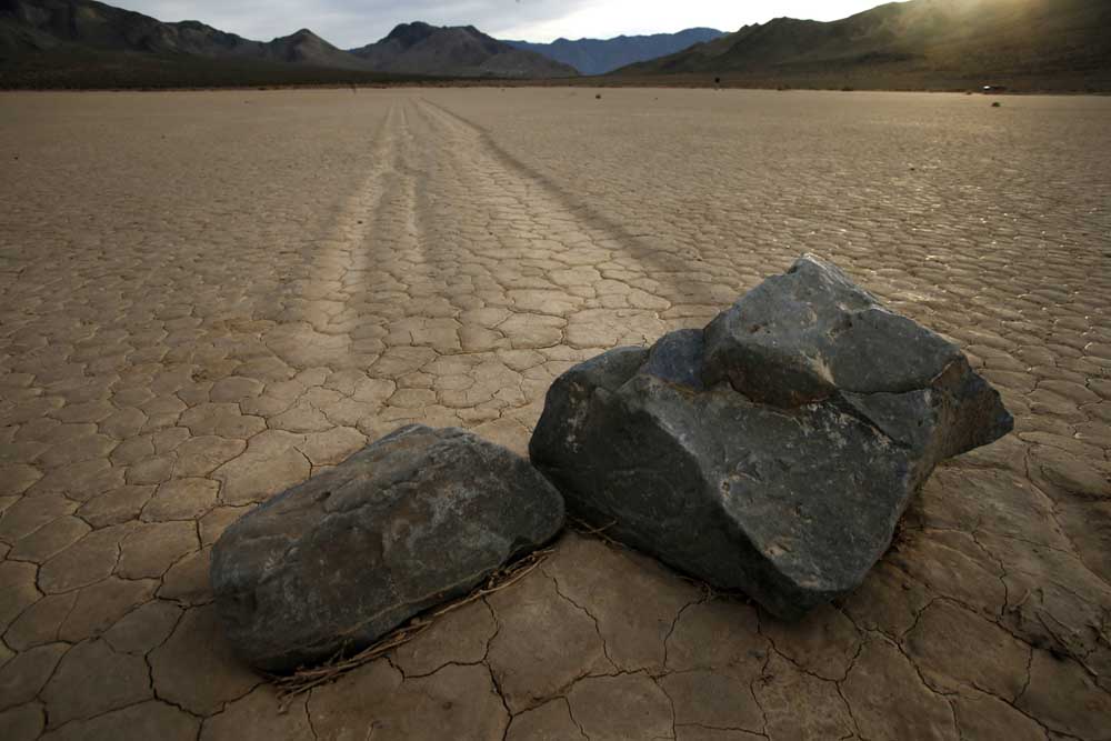
- Mark Boster / Los Angeles Times via Tribune News Service Even though the mystery of the moving rocks and their even more mysterious tracks has been solved, the Racetrack is still a huge part of the lore of Death Valley National Park.
DEATH VALLEY NATIONAL PARK — It took me several trips here to realize this, but if you know where to look and time it right, Death Valley is one giggle after another.
Sure, it’s vast, wind-raked, sun-baked and empty-seeming. Yes, it will confirm your puniness in the universe. And it might kill you if you’re in the wrong place at the wrong time without water or cover.
Trending
But there’s plenty of weird science, quirky history and plain fun in these 3.4 million acres of dry lake beds, towering dunes and wind-scoured mountains, which have been a national park since only 1994. The last time I made the 215-mile drive from Los Angeles to Death Valley, in December with Los Angeles Times photographer Mark Boster, seemed especially revealing.
Part of this was the weather. The first storm in a year had just dumped a burst of rain, leaving puddles and green stubble in a place that’s famous for lacking them.
The other factor was where we went. This time, between visits to well-known spots such as the salt flats at Badwater (the lowest spot in North America, at 282 feet below sea level) and Dante’s View (where the wind threatened to blow us into Nevada), we spent hours in a Jeep on back roads in Titus Canyon and Racetrack Valley.
Those narrow, rocky, twisting routes weren’t especially comfortable, but they allowed us to see the landscape in a new way.
On Day One, following California State Route 190 from the Owens Valley and down into Death Valley, we fell into a race with the setting sun and reached Badwater in the nick of time.
Pools of water gleamed on the crusty salt flats. Snow shined on Telescope Peak, about 10 miles west. Half a dozen French tourists took turns hollering “Echo!” at the mountains rising abruptly in front of us — audio selfies. Affixed to the rock more than 280 feet above us, a small white sign marked sea level.
Trending
As the purple sky darkened, the distant ridgelines seemed to sharpen. The French fled for dinner. Suddenly it was very quiet, and I felt as alone as one of those golf balls the Apollo astronauts left on the moon in 1971.
If you’re carrying a camera, sunrises and sunsets matter here. Photographers scheme endlessly to capitalize on every one of them (especially in winter, when the sun comes up at a more civilized hour). But distances change those ambitions. Badwater is 41 driving miles from the Mesquite Flat Sand Dunes. Which are 65 miles from Dante’s View. Which is 96 miles from Scotty’s Castle. Which is 29 miles (mostly gravel) from the Racetrack.
If you’re not careful — or even if you are — you may end up the way we did on Day Two, rushing from Scotty’s Castle to the dunes at Mesquite Flat but arriving too late to catch the last of the golden light.
All that was forgotten on Day Three, when we turned off the pavement at Ubehebe Crater and rumbled onto 27-mile Racetrack Road.
People mostly talk about the road’s eerie destination. But if you’re a driver who likes kicking up a little dirt and a few loose rocks (in the right kind of vehicle), the road alone is notable.
Right away, a wild valley opens up. A washboard path winds through a Joshua tree forest as sprawling and Seussian as any in Joshua Tree National Park. At mile 20, you reach Teakettle Junction, a strange metallic oasis of dangling cookware where dozens of campers have autographed their kettles and hung them on the sign. At mile 27, you park and walk.
If you had asked me that night, I would have said Racetrack Road was the most fun I’d ever had driving in the park, even though we never got over 25 mph.
Ah, but then came Day Four. Titus Canyon Road, another unpaved 27-mile wonder, is a one-way route that begins just west of the park boundary and the Nevada state line. Once you’ve reached the gravel turnoff on Nevada State Route 374, you head straight across a flat patch of desert for several miles, then disappear into a canyon as the Grapevine Mountains rise around you, steadily taller, steeper and redder.
Usually, this is the busiest backcountry road in the park, but traffic was light on this early December weekday, and in three leisurely hours we saw a handful of other vehicles. As I slowed from 20 mph to 10 and then to 5, the road fell and rose, and the turns tightened into a series of hairpins above steep drops. There were limestone formations and petroglyphs.
At a turnout on a rare straight stretch, we stopped to inspect Leadfield, a ghost town that never really lived. Finally we squeezed through Titus Canyon Narrows, a 1½-mile stretch where the canyon walls come within 20 feet of each other, and emerged just in time to catch a pink sunset.
And if you had asked me that night, I would have said that sunset was the happiest surprise of the trip. But then came DayFive.
It was our last morning in the park. We had decided to shoot dawn on the dunes at Mesquite Flat. Sure enough, by 6:30 a.m. the horizon had begun to burn red in the east, despite clouds overhead. We stood under two skeletal trees.
Then came the raindrops, a strengthening drizzle dappling dunes that get perhaps 2 inches of rain per year. The sun was brighter now, but I had to look away because in the west, beyond the limbs of those skeletal trees, a rainbow arched above the darkened dunes.
Boster went nuts with his cameras, of course. I snapped too, but gave up after a while. In Death Valley that morning, there was more going on than any camera could capture.
So I did the next best thing.
I stood there, grinning like an idiot.
Marketplace


Best of the Best of Bend 2025

-
eEdition

-

-