Need a change? Bike on lush McKenzie
Published 12:00 am Wednesday, October 7, 2015
- Need a change? Bike on lush McKenzie
MCKENZIE BRIDGE —
The McKenzie River Trail is only about an hour’s drive west from Bend, but it might as well be a world away.
How can one of the most heralded ribbons of singletrack in the country be located in Oregon, but not exactly in Central Oregon, which over the last 10 or 15 years has become a national hot spot for mountain biking?
Maybe we should not worry about that, but rather celebrate the fact that the MRT — as it is known among trail enthusiasts — is ONLY an hour away.
The trail is so different from the high desert style of singletrack we are accustomed to here. Rather than a dusty trail through sage brush, ponderosa pines and manzanita, the MRT is a damp path through a heavy canopy of mossy old-growth trees along the clear McKenzie River surging deep in the Willamette National Forest.
That’s not to knock our trails here in the Deschutes National Forest. It’s just that during this time of year, when a lack of rainfall can make for dusty trails, the MRT remains largely dust-free on the wet west side of the Cascades.
In 2008, Bike Magazine declared the McKenzie River Trail the best mountain biking trail in the United States. I cannot argue with that (though admittedly I have rarely ridden my bike outside the Northwest).
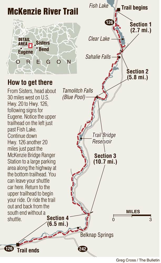
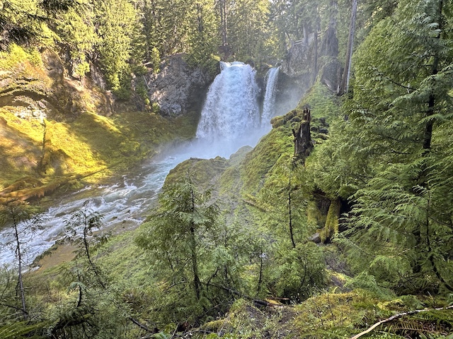
On its north end, the trail starts out easy around the west side of Clear Lake and becomes extremely technical over the rugged lava rock near Sahalie Falls and Koosah Falls all the way to Trail Bridge Reservoir.
Then, just when you are totally cooked and can’t go on, the trail turns into a smooth, easy ride along flowy singletrack all the way down to the McKenzie Bridge Ranger Station.
From the start near Clear Lake, about 30 miles west of Sisters along state Highway 126, to the finish 26 miles south near the McKenzie Bridge Ranger Station, riders are treated to some of the most stunning scenery in the state.
But that view comes with a price for the fat-tire set: They must tackle some challenging portions of trail, negotiating jagged rocks and steep cliff-side portions with nothing but the rushing water below. The north-to-south ride includes an elevation loss of 1,600 feet, but it nevertheless remains an aerobic challenge.
To skip the more difficult portion of the trail, I opted to ride the MRT last week as an out-and-back from the south end of the trail near Paradise Campground. Sure, I would miss out on the waterfalls and Clear Lake, but I was more interested in riding the easier section of the singletrack. I have ridden the entire trail several times, and each time the extensive lava rock section became excessively tiring.
Technical rock sections are dispersed throughout the McKenzie River Trail, but generally, the path is less technical from Trail Bridge Reservoir to the south end of the trail near the ranger station.
As I started from Paradise Campground, the trail climbed gradually through the lush, green forest. The river provided cool air as I continued along the singletrack, which cuts through Belknap Springs and crisscrosses the river.
The McKenzie River is crystal clear and ever-changing, from calm, rocky pools to churning whitewater. The trail undulates along the river, at times rising hundreds of feet above the water.
Although the southern half of the MRT is considered the easier portion, it does include lots of rocky areas that make a full-suspension bike worthwhile on some of the more technical sections.
One constant along the trail — and what makes it so different from any trail in Central Oregon — is the lush greenery of the Willamette National Forest. Bright green ferns, moss-covered Douglas firs and endless deciduous trees line the trail and provide a nearly constant canopy. Fall colors of yellow and red were beginning to arrive last week.
Numerous narrow bridge crossings are required along the McKenzie River Trail. Most of the bridges are so narrow that cyclists must pop their bikes up on the back wheel and push the bikes in front of them as they walk across.
One striking characteristic of the trail is how dark it can be in the middle of a bright, sunny day. The forest is so thick in spots that heavy shade is almost constant. The endless vegetation makes for prolific bug life, and at one point alongside the trail I noticed a spider nearly the size of a golf ball in the middle of a perfectly spun web.
I rode north along the trail for nearly two hours before tiring to the point that I felt compelled to turn around near Olallie Campground, just a few miles south of Trail Bridge Reservoir.
When I did turn around and begin riding back, I realized how much I had actually been climbing. The return ride was deceptively fast as I cruised through the quiet, dense forest, the only sound the rushing of the river. I encountered a few other bikers and hikers, but otherwise I enjoyed lots of solitude.
By the time I arrived back at Paradise, I had ridden about 21 miles in just short of four hours, and I was spent. A few years ago, I rode the entire trail and it required about six hours. That’s just too long in the saddle for me these days.
The out-and-back ride from the south end offered a memorable experience, providing plenty of scenery along one of the country’s most renowned mountain biking trails.
— Reporter: 541-383-0318,
mmorical@bendbulletin.com

Best of the Best of Bend 2025

-
-
-