Travel: Hiking Kauai’s Alakai Swamp in Hawaii
Published 12:00 am Sunday, December 20, 2015
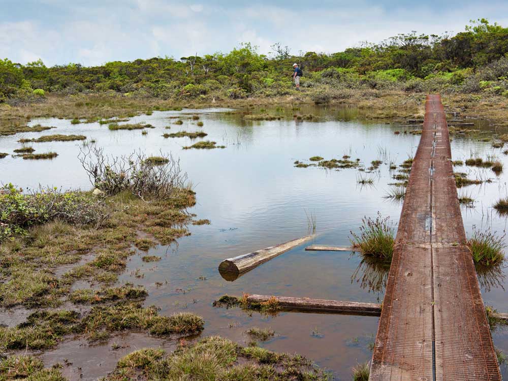
- Barb Gonzalez / For The BulletinA primitive boardwalk of planks covered with chicken wire crosses a section of the Alaka'i Swamp at 4,000 feet elevation on the Hawaiian island of Kaua'i. It passes an old telephone pole from a line attempted and abandoned during World War II.
KAUA’I, Hawaii —
A primitive plank boardwalk, across water redder than rust, is not something to inspire confidence in a hiker, especially an exhausted one.
Trending
After 3 miles of climbing clay embankments on muddy handholds, descending scores of hand-hewn steps covered with chicken wire for traction and brushing aside the gnarled branches of ohi’a trees on level ground, we scrambled to find our footing.
Now, with our goal less than a mile away, photographer Barb Gonzalez and I were well and truly in the bog that we had come to see. The boards laid across the Alaka’i Swamp more than three decades ago were rotting away, and where they had fractured or disintegrated, our boots sank into gray mud, and we continued at a slogger’s pace.
Around us was an almost unimaginable wilderness, one which time seemed to have forgotten. We were captivated by the sights of bright red lehua flowers and the hand-shaped leaves of olapa trees, by the licorice-like smell of mokihana berries and the pungent, earthy odor of the hapu’u fern.
Moreover, the constant calls of native birds — red-feathered ‘apapane and i’iwi, the lustery green ‘amakihi honeycreeper, the wren-like ‘elepaio and others that have not been heard for decades beyond this swampland — enraptured us with nature’s symphony, even if our ears couldn’t tell a puaiohi from an o’o.
If ever a journey was itself the destination, this was it. But the climax was also worth the hike. The path finally rose past the swampy turf, re-entered an ohi’a woodland and emerged at a tiny lookout atop the contorted cliffs of Wainiha Pali. From a rustic wooden platform known as Kilohana Lookout, barely large enough for eight people, a view extended across the entire north shore of Kaua’i, from Hanalei Bay to rocky Kilauea Point.
The panorama is subject to weather, of course. And here, atop a 4,000-foot cliff, visibility is no guarantee. We were, after all, further from those clear sandy beaches than from the rainiest place on Earth.
Trending
‘Too much water’
This may not be the sort of tropical vacation one typically imagines. The percentage of people who travel to Hawaii to wade through a muddy bog must be very small, indeed. But then, the Alaka’i is not a normal sort of swamp.
It spreads over 18 square miles in the high country of Hawaii’s oldest and most northerly island. It is nothing like the grassy Florida Everglades, nothing like the mangrove swamps of the Mississippi bayou country, with snakes and gators hiding around every corner. There are no predators here, only rain and mud.
In the very distant past, 6 million years or more, according to geologists, the Alaka’i was the caldera of the volcano that gave birth to the island of Kaua’i. It gradually filled with porous lava and nurtured twisted trees and shrubs fed by rainfall from Mount Wai’ale’ale, which rose to 5,148 feet above the Pacific.
The average annual rainfall on Wai’ale’ale is something like 460 inches. That’s an approximation. The gauging station on the mountain slopes has been known to overflow, leaving inaccurate readings. That’s what happened in 1982, when the gauge maxed out at 683 inches. Apparently there’s a place in eastern India that has recorded more rain in a single year, but its precipitation is not as consistent, month after month, year after year, as that of Kaua’i.
All that rainfall has to go somewhere. It certainly feeds the rivers, short but wide and deep, that flow into the Pacific Ocean in every direction. The Waimea, Hanapepe, Wailua, Hanalei, Wainiha and other streams continually drain the mountain’s central massif.
But there’s a substantial amount that doesn’t have anywhere to go, and so it seeps into the boggy soils of the Alaka’i and stagnates on its surface. This woebegone landscape is a last refuge for birds and plants that have nowhere else to hide. According to the U.S. Geological Survey, Hawaii accounts for less than 1 percent of U.S. landmass but 75 percent of its documented plant and animal extinctions.
Mount Wai’ale’ale (the Hawaiian name means, literally, “too much water”) is more or less permanently wet. At the Kilohana lookout, 3.8 miles from the Koke’e State Park trailhead, we spoke to a couple of men who had hiked in just before us. One of them told us he had been a groundskeeper for the past 12 years at the Limahuli Garden, a national tropical botanical garden at Ha’ena, straight below us and north a few miles.
“Does it always rain up there?” asked a younger hiker, glancing furtively in the direction of Wai’ale’ale’s summit, which even now was casting windblown sprinkles in our direction.
“No, not always,” the gardener said dismissively.
“How many times have you seen the summit?” The hiker persisted.
He sighed and began counting on his fingers. “In 12 years? About seven,” he said.
Swampy mystique
I have been fascinated with the Alaka’i Swamp since I was a young journalist, just out of university and working for The Honolulu Advertiser. A week’s trek into the magical Na Pali cliffs on the 11-mile Kalalau Trail had piqued my interest in exploring other parts of Kaua’i.
My colleague Jan Tenbruggencate, only a few years older than myself, told me about the Alaka’i. He told me about the unique flora and fauna, about its relative inaccessibility, about attempts to build a telephone line across the bog during World War II. (A few fallen poles can still be seen, victims of unstable ground and high winds.) I made plans to visit. Then I left Hawaii for another job and those plans were put on hold.
Tenbruggencate, meanwhile, moved permanently to Kaua’i as The Advertiser’s correspondent on “the Garden Isle.” Four decades later, The Advertiser no longer exists, but he’s still there. There may be no one who knows the island better than he. Roundish in shape, with a 90-mile coastline and a population of fewer than 70,000 permanent residents, Kaua’i doesn’t attract the same number of tourists as Honolulu or Maui, for example, but its scenic charms are well known to movie goers around the world. (Think “South Pacific” and “Jurassic Park.”)
Naturally, I turned first to my old friend in planning my Alaka’i escape. Had he ever tackled the swamp? Many times, he said. He had even visited the gauging station on the upper slopes of Wai’ale’ale with a small U.S. Geological Survey team in 1987. Dropped by helicopter (the difficult hike would have taken days, he said), the team spied a nesting o’o, a bird that hadn’t been spotted in decades, and which hasn’t been seen since. It once was a source of feathers for royal Hawaiian capes. Now, it may be extinct.
That story merely added to the mystique the swamp held for me. And I would find it easier to get there, my friend said, thanks to improvements made to the trail in 1991. That was when the “boardwalk” was built — it’s actually little more than two planks laid side by side — and hundreds of wire-covered steps were installed on steep hillsides. More recently, a line of mesh fencing has been built to keep wild boars (introduced centuries ago and now widely hunted) from ravaging the delicate Alaka’i environment. Still, it’s been a quarter-century since the boards were placed, and in many places, they are not holding up well.
Canyon and cliffs
For our Alaka’i adventure, Gonzalez and I based ourselves on the west side of Kaua’i at the Waimea Plantation Cottages, a compound of renovated sugar planters’ homes that spread along a Pacific beachfront. Giant banyans, draping casuarina trees and palms heavy with coconuts blister the grounds, while flowering hibiscus add color and cast a delicious scent into the salt air.
Perhaps no location in Kaua’i has as much history as Waimea. This was the capital of the original kingdom of Kaua’i before its conquest by King Kamehameha around 1810, and it was where Captain Cook landed in 1778 and where Russia maintained a fort from 1817 to 1853. All were at the mouth of the Waimea River, the largest stream on the west side of the island.
Only a few miles upriver from its mouth, the Waimea River is immersed in the Waimea Canyon, one of the principal tourist attractions of Kaua’i. Ten miles long and up to 3,000 feet deep, the canyon’s deep red soils are accented by the greens of rainforest foliage, making it exceptionally striking when cloudy mists trail through its walls.
Author Mark Twain dubbed it “the Grand Canyon of the Pacific” based upon hearsay; he never actually saw it himself. We did him two better, enjoying great views from a series of lookouts off Highway 550, later splurging on a helicopter tour of the island, during which we enjoyed close-up views of majestic waterfalls plunging from the precipices below Wai’ale’ale’s summit.
On the day before our hike, we drove 18 miles on a steady uphill from Waimea to the Koke’e State Park headquarters, just above the canyon. Armed with dinner fixings from the Ishihara Store (there’s no place for dinner in these environs), we set up housekeeping in an exceedingly rustic cabin, one of a handful that comprise the Lodge at Koke’e.
Before sunset, we peered over the edge of the Kalalau Lookout, Kaua’i’s most famous viewpoint, at the isolated and paradisiacal Kalalau Valley below. I recalled how many years earlier, I had ventured into this area to discover a community of largely unclothed “hippies” who dined on wild tropical fruit and harvested their own marijuana. That society was later flushed out, and the cliff-side trail into Kalalau is considered largely unsafe.
Today, the best way to experience the incomparable cliffs of the Na Pali coastline — of which Kalalau is merely one of a series of spectacular valleys — is by sea. Kaua’i Sea Tours is one of several companies that operate catamaran cruises out of Hanapepe Bay at ‘Ele’ele, just 8 miles east of Waimea. The corrugated faces of the 4,000-foot cliffs, long-tailed white tropicbirds waltzing before them, endangered monk seals lying on its beaches, are an unforgettable sight.
Cock-a-doodle-doo
We might have been dreaming, but the resident poultry of Koke’e State Park would have none of that. I prefer the sound of crashing surf to a good-morning cock-a-doodle-doo, but Kaua’i’s colorful but noisy wild chickens are worse than feral cats. The birds, which seem to be everywhere, are descendants of 19th-century plantation workers’ flocks, kept for eating and cockfighting. When Hurricane Iniki ravaged the island in 1992, many coops were destroyed and birth control went out the window.
At any rate, nature’s alarm gave us an early start. Our hike began after we parked our rental car at the Pu’u o Kila Lookout, at the end of the paved highway. Back in the 1950s, an attempt was made to build a road along this crest to connect with the north end of the island near Ke’e Beach; this was quickly deemed impractical, but only after it left a broad scar through the brushy woodland here.
That “scar” is now the Pihea Trail. About a half-mile from its start, it narrowed and became markedly more rugged. We even wondered if it were passable. We found ourselves clinging to tree roots and scrambling for footholds as we clambered up and down steep embankments of wet red clay. Mists swirled in and out of the ohi’a until we reached a trail junction, beside a boar fence, that pointed us downhill.
We descended about three-quarters of a mile to a four-way trail junction, turned left through a thicket of yellow-barked lapalapa and soon descended nearly 300 steps to a crossing of the Kawaikoi Stream. We climbed again into an ohi’a forest, birds whistling their warnings all around us, then encountered the final boggy boardwalk.
The official one-way distance of this hike is 3.8 miles. But no one should expect to cover that distance in 90 minutes at the average pace of a Cascade Range hiker. We found the various obstacles limited us to a pace of not a lot more than 1 mile per hour, making this adventure a highly rewarding, all-day pursuit.
Playing tourist
The remainder of our Kaua’i trip was more of the traditional tourist type. We flew in and out of the international airport in Lihu’e, the main island town, and spent a couple of nights each in resort-heavy Po’ipu, on the south shore, and at the laid-back Hanalei Colony Resort, near the end of the highway on the north shore.
On Kauai’s south shore, we zip-lined beneath Ha’upu Ridge with Koloa Ziplines; explored the quaint artists’ community of Hanapepe; and ate marinated ahi tuna, known as poke, from the Koloa Fish Market.
Along the east shore, near the resort center of Kapa’a, we found the not-so-touristy Kamokila Hawaiian Village by the banks of the Wailua River, and enjoyed an afternoon exploring its re-created traditional Hawaiian dwellings.
We watched red-breasted frigate birds, brown boobies and Laysan albatrosses soar beside the lighthouse at Kilauea Point National Wildlife Refuge. We found the Hawaii state bird, the nene goose, among moorhens and plovers in the taro fields of Hanalei National Wildlife Refuge. We made a detour to glimpse at Princeville, the north shore’s famous luxury resort, and relaxed over dinner at Bar-Acuda, one of Hanalei’s most popular restaurants.
Our favorite north shore experience, undoubtedly, was a visit to Limahuli Garden, one of five components (four in Hawaii) of the National Tropical Botanical Garden. Less than a mile from the end of the road, it embraces a hillside of terraces built of lava rock by ancient Hawaiians to flood their taro patches.
We were met at Limahuli by Brian Ross, owner of Photo Safari Hawaii. As knowledgeable in Hawaiian history and botany as he is in techniques of maximizing available light in nature photography, Ross led a half-day tour of the gardens that left us wanting to join him again, perhaps on Maui or the Big Island.
It didn’t seem to matter that we couldn’t see the top of Mount Wai’ale’ale.
— Reporter: janderson@bendbulletin.com
Marketplace


Best of the Best of Bend 2025

-
eEdition

-

-