New trail boasts great views in the ‘Issiquah Alps’
Published 12:00 am Wednesday, January 27, 2016
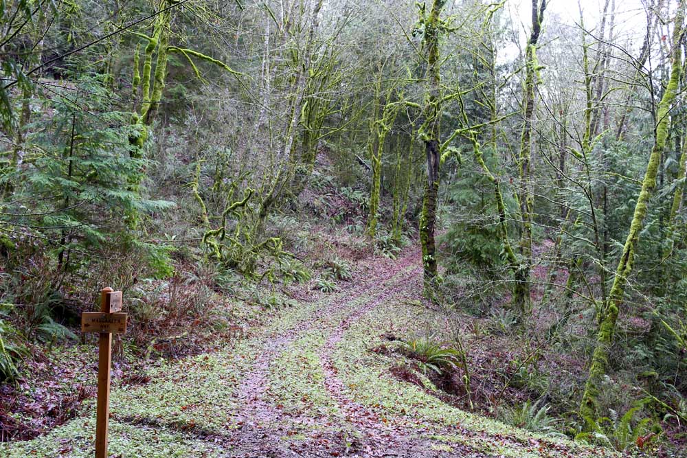
- John Lok / The Seattle TimesThe area around the Margaret’s Way trail is surrounded by moss-covered trees, in Issaquah, Washington. Completed last summer, this 2.7-mile trail connects the west side of the Cougar/Squak Corridor to several loops and short trails.
ISSAQUAH, Wash. — Washington is filled with endless possibilities for half-day hikes during the summer. But during winter, Seattleites who don’t hibernate are pretty predictable. Many hit the lowland trails around Tiger, Cougar and Squak mountains until the high country thaws out by late spring.
That’s why every weekend, the so-called “Issaquah Alps” fill up as Subarus and other vehicles overflow from the parking lots onto the shoulders of the main roads.
Trending
You can avoid the mayhem. As an alternative, Margaret’s Way is maybe the best option to avoid the crowds of dog walkers and trail runners who clog the trails along the Interstate 90 corridor.
Completed last summer with little fanfare, this 2.7-mile trail meanders from the west side of the Cougar/Squak Corridor to a handful of loops and short trails.
Because it remains lesser-known — mostly neighbors hike here — the parking lot often sits half-empty.
Before King County Parks, along with volunteers who carved out this trail on Squak Mountain, the Issaquah Alps Trails Club bushwhacked through the area. Club members concluded that a new trail would likely have to be short since it’s a challenging topography given the drainage creeks in ravines, the wetlands and the steep terrain, said David Kappler, club president.
“It ended up being a significant trail, a much better trail and a much better experience,” said Kappler, who scouted the area with club members last year. “You have really significant, large evergreen trees, rocks, cliffs … and views of the wooded parts of Cougar (Mountain). It has quite a mountain feel to it even though it’s close to a million people.”
Not a tough climb
Trending
Margaret’s Way gains only 1,250 feet, a moderate hike that a reasonably fit person can do with little sweat.
It doesn’t have the majestic views of East Tiger or West Tiger One. But at the end of Margaret’s Way, head southeast a couple hundred yards onto a long, narrow dirt path, Debbie’s View Trail, and you get a view of Mount Rainier and, on a clear day, the south Sound.
Margaret’s Way also serves as a gateway to a handful of other trails including the popular Chybinski Loop to the north, and to the east, Bullitt Fireplace Trail, a popular picnic area.
Part of what is now Margaret’s Way was once a privately owned RV campground set to be sold to a logging company until locals and environmentalists lobbied the county to intervene to preserve this recreation area.
The county parks agency obliged in 2014, buying this 226-acre parcel for $5 million with money from its parks levy, the Conservation Futures fund and real estate excise taxes.
The county then built Margaret’s Way and will soon add restrooms and water faucets there. (Currently, there are portable toilets but no water source.)
By next year, the county hopes to build an Environmental Learning Center near the trailhead to be used for school field trips.
The county plans to expand this recreation area. Among possibilities is to put out bids for a zip-line operation, which would need Metropolitan King County Council approval. No timetable has been set for that, said Doug Williams, spokesman for county parks.
Named for planner
The trail’s name honors the late Margaret MacLeod, an Issaquah parks planner who secured millions of dollars for conservation projects and helped preserve from development hundreds of acres in the Issaquah Alps and the surrounding area.
Margaret’s Way has about a dozen switchbacks and a couple of short but steep stretches that can get slippery after a storm. But for the most part, it’s a gradual climb.
A quarter-mile up, on a clear day, you get a southwest view of the Olympic Mountains between the hemlocks and big-leaf maples. The trail then transitions into an alder forest that “is just beautiful when the leaves change colors,” said Jen Gradisher, of Washington Trails Association, which helped build Margaret’s Way.
A half-mile up, the trail is under cover of the dense forest. Part of the trail follows an old, steep service road, which can get slick and muddy. Later this year, work crews will reroute that part of the trail to higher ground to make it less prone to flooding and safer for hikers.
About 1.5 miles up, the trail zigzags through a forest of second-growth Douglas firs. Dress warmly. On a recent visit, I could hear the whistling wind on the south-facing side of the mountain. Two downed hemlocks blocking the path foreshadowed the windy conditions that awaited us farther up.
Before they could even carve out a trail, work crews had to clear a number of giant trees that toppled after rainstorms. “We burned a lot of chain-saw gas on this trail,” a parks spokesman said.
Marketplace


Best of the Best of Bend 2025

-
eEdition

-

-