Washington’s Mount Rainier is at its best in summer
Published 12:00 am Sunday, July 24, 2016
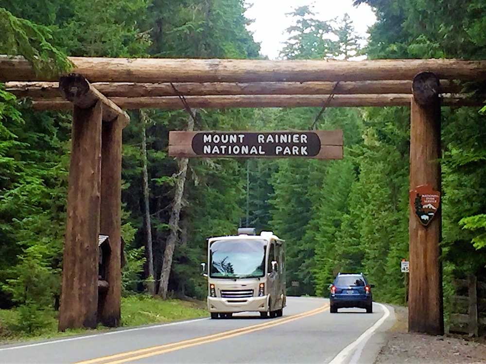
- John Gottberg Anderson / For The BulletinVacationers drive through the gateway arch at the northeast entrance to Mount Rainier National Park. Celebrating its 100th anniversary as one of the countrys first national parks, Rainier covers 369 square miles in the heart of the Washington Cascades.
CRYSTAL MOUNTAIN, Wash. —
When the clouds broke over Mount Rainier, I was captivated by a view like none other.
Trending
Soaring through the mist, the solitary giant of the Cascade Range loomed before my eyes like the Everest of the Northwest.
I stood at 6,800 feet, on the patio of the Summit House atop Crystal Mountain. Between me and the massive crest before me, I could see nothing but a blanket of white, save a bed of colorful sunlit flowers and a few hardy stalks of alpine spruce.
Rising to 14,410 feet, more than 3,000 feet higher than Oregon’s Mount Hood, Rainier is the most glaciated peak in the Lower 48 states. It is forever hooded by snow, and even on those rare days when it is so clear that it dwarfs the skylines of Seattle and Tacoma, it is stirring up its own weather systems.
This great mountain captures the moisture-laden air that moves eastward from the Pacific, wringing it dry on its verdant slopes. Douglas fir, western red cedar and western hemlock stand needle-to-needle in the old-growth forests on its lower slopes, dominating a dense forest canopy that makes a perfect home for deer, elk, black bears, mountain lions and great multitudes of other species.
At higher elevations, snowfall is epic. Paradise Inn, at 5,400 feet altitude on Rainier’s south slope, corrals an annual average of 680 inches of snow. Twenty-five named glaciers — headed by Emmons Glacier, the largest in the United States outside of Alaska — flow from its slopes. And when the snow melts (often not until midsummer) from glacier-free subalpine meadows, the intense sunlight upon saturated volcanic soils produce some of the most unforgettable wildflower displays on the planet.
The national park
Trending
I was a little early for the peak wildflower season. From my perch at Crystal Mountain, had the clouds fully cleared, I would not have seen many flowers besides those at Summit House. Instead, I would have observed the fan-like upper forks of the White River flowing north, then west, toward its ultimate rendezvous with Puget Sound. I would have seen them as they ran from the foot of the Emmons Glacier, across a broad gravel floodplain, through silty turquoise ponds and between dense stands of conifers.
Later that day, at the Sunrise visitor center and day lodge, at 6,400 feet, the highest point in Mount Rainier National Park to which one can drive, I saw all this and more from a different perspective. White pasqueflowers and yellow cinquefoil and scarlet paintbrush were just beginning to make their presence known in the fields of Yakima Park. Prominent signs urged day hikers to leave the meadows untrodden to protect the sensitive ecosystem.
Mount Rainier National Park covers 369 square miles in the heart of Washington’s Cascades, barely 30 miles southeast of Tacoma as the crow flies. Almost square in shape, it surrounds the gigantic volcanic cone of Rainier, with roads extending nearly the length of the park along its southern and eastern boundaries. With the exception of the Sunrise spur and a couple of access points in the northwestern corner of the park, it is almost entirely wilderness.
Native Americans knew this mountain as “Tahoma.” Late 18th-century English explorer George Vancouver, who beheld the peak from his ships in Puget Sound, named it Rainier to honor a fellow British naval officer, Admiral Peter Rainier.
Vancouver didn’t see the volcano erupt; except for an expulsion from a steam vent near its summit in 1894, it’s been about 1,000 years since any real activity here. But that doesn’t mean Rainier won’t erupt again. Geologists describe the mountain, formed about half a million years ago near the edge of the North American tectonic plate, as “episodically active.” National Park Service officials believe the peak would give ample warning before an eruption, but they warn there remains a threat of unexpected mudflows at any time.
Crystal Mountain
Because the park is so large, I focused a recent visit on its northeast sector. Arriving on State Route 410 from Enumclaw, northwest of the mountain, I traveled the Mather Memorial Parkway and spent two nights at the Crystal Mountain Resort before continuing through Chinook Pass to Yakima and making my way back to Oregon on U.S. Highway 97.
The parkway was named for Stephen Mather, the first director of the National Park Service, which is celebrating its 100th birthday this summer. While the actual anniversary date is Aug. 25, mountain hosts are focusing a summerlong campaign upon attracting younger-generation visitors with a range of activities.
Crystal Mountain, which sits at the head of the Silver Creek watershed, is a popular winter ski resort with a scaled-down schedule during the snow-free season. Its biggest summer attraction is the Mount Rainier Gondola, which climbs more than 2,000 feet to the highest-elevation restaurant in the Northwest. Open at 10 a.m. daily, the eight-seat gondolas take 12 minutes to make the ascent, which it will continue to do through Sept. 18 this year.
I made my home for two nights at The Alpine Inn, one of three properties operated under the umbrella of the family-owned Crystal Mountain Hotels. It had the spirit of a traditional European ski lodge — perhaps not surprising, as it was built in 1964 by an Austrian skier who decorated it with black-and-white photographs of skiers of my generation.
The Alpine Inn Restaurant on the first floor had good schnitzel and goulash, while The Snorting Elk Cellar in the basement offered a grudging concession to modern tastes with the establishment’s only television. Although my second-floor room had no such screen, it did offer a good bed, a private bath and Wi-Fi service.
Sunrise
It takes about 45 minutes to drive the 25 miles from Crystal Mountain — 6 miles off the Mather Parkway — to Sunrise Ridge. Drivers pay a fee at the White River Entrance kiosk and proceed to switchback for 14 miles up a road that is only open three months a year, until snow falls in early October.
Views en route are spectacular, especially at Sunrise Point, with its three-directional panorama extending up and down the White River and across a series of subalpine lakes linked by a popular trail.
The highlight, though, is Sunrise itself. The community has two principal structures, a National Park Service visitor center with educational exhibits and backcountry travel information, and a rustic day lodge with a cafe and gift shop. Both buildings serve the trails and meadows beneath Sourdough Ridge and above the Wonderland Trail, a strenuous, 93-mile, up-and-down circuit of the national park with ascents and descents of as much as 4,000 feet.
Few of the trails in the Sunrise area are that difficult, although at this elevation, fitness is especially important. A popular hike is the steadily rising walk to the top of 7,006-foot Dege Peak, climbing only about 600 feet in 1.7 miles. From here, the view of the northeast slope of Mount Rainier is impressive, indeed, with the long tongue of Emmons Glacier descending below Camp Schurman, a park-staffed climbers’ outpost at the 9,500-foot level of the main mountain.
White River
Many climbers — nearly half of the 10,000 who annually attempt an ascent succeed — make their base at the White River Campground, a 3-mile hike but an 11-mile drive downhill from Sunrise. They get wilderness camping permits from the information center at the White River Entrance, then head up the 3.2-mile Glacier Basin Trail to establish an overnight camp before continuing the next day to Camp Schurman.
I wasn’t prepared for a climb, but a short walk in the woods was a very appealing notion. I headed up the Glacier Basin Trail, and not quite a mile from the White River Campground, I turned left onto a half-mile spur route known as the Emmons Moraine Trail.
This moderately easy trail follows the ridge of debris created by glaciation during the last Ice Age more than 10,000 years ago, rising about 700 feet to a clearing from which Emmons Glacier is clearly visible. While the upper glacier is an icy field of towers and crevasses, its lower section is covered with debris from a massive rock fall in 1963.
From a distance, this looks like dirt, but it is actually littered with automobile-sized boulders. The debris insulates the ice beneath it, so that while many other glaciers are in retreat, the Emmons is slowly advancing. The White River seeps from what appear to be a trio of large caves at its head. The view down this glacial valley is punctuated by small unnamed lakes, bright teal in color, brilliant jewels of glacial sediment reflecting sunlight.
The trail to Emmons Moraine, and most of the path to Glacier Basin, was destroyed by a massive flood in 2006. A new trail wasn’t completed until 2010, but it’s a wide and wonderful path with good bridges and only one makeshift, single-plank river crossing. Waterfalls, wild mushrooms, beautiful woodland flowers and the songs of forest birds make it a great way to pass a couple of hours in the wilderness.
Other hikes
I discovered another lovely trail near the park’s Stevens Canyon entrance at it southeast corner. The Grove of the Patriarchs Trail is an easy 1-mile walk into an old-growth forest on a riparian island on the southward-flowing Ohanapecosh River.
Well-trodden by visitors from 8 to 80, the track sits at an elevation of about 2,000 feet. It is marked by a series of interpretive signs describing flora and fauna, and concludes — after an entertaining crossing of the river on a safe but swaying suspension bridge — amid giant cedars and Douglas firs. Some of these trees are hundreds of feet tall and centuries old.
Where I exited the park at 5,432-foot Chinook Pass, I paused to eat my picnic lunch (prepared for me by the kitchen at The Alpine Inn) beside pretty Tipsoo Lake. This shallow tarn, framed by a couple of peaks on the national park’s eastern boundary, is circled by a gentle trail.
In the western distance, though, the summit of Mount Rainier is no stranger. Even from this perspective, it rises high above the rest of the environment, making it clear that it dominates the Cascade Range for many, many miles in every direction.
— Reporter: janderson@bendbulletin.com


Best of the Best of Bend 2025

-
eEdition

-

-