Hiking trip reveals the wow of the Wallowas
Published 12:00 am Wednesday, August 31, 2016
- Hiking trip reveals the wow of the Wallowas
LOSTINE —
Taking a wrong turn in Oregon’s largest wilderness area could easily lead to disaster.
Trending
Luckily, we were in better hiking shape than we had thought, as a planned 12-mile round-trip trek to Minam Lake last week turned into a 20-mile, seven-hour haul with 4,000 feet of elevation gain through the Eagle Cap Wilderness.
We took a right when we should have taken a left. But no matter. Wherever you venture into the remote Wallowa Mountains of northeast Oregon, you are treated to an unforgettable experience highlighted by dramatic alpine scenery.
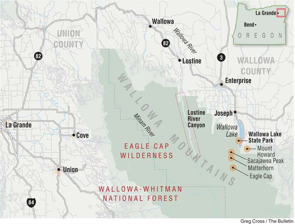
The Eagle Cap encompasses nearly 400,000 acres, 31 peaks taller than 8,000 feet, and 535 miles of trail open to hikers and horseback riders.
Rugged granite ridges, green meadows, deep, glaciated valleys and 60 lakes make the Wallowas a must-see destination for hikers and backpackers who crave a little more adventure.
A friend and I made plans for a four-night camping and hiking trip into the Wallowas, the first visit to the area for both of us. The goal was to see as many different parts of the wilderness as we could in three full days, without pushing ourselves past our limits.
Most who visit the Wallowas stay near the small town of Joseph or camp at Wallowa Lake State Park at the edge of the mountains.
Trending
Other camping areas are available at Hurricane Creek or in the Lostine River Canyon just west of Joseph. The three primary trailheads into the Eagle Cap Wilderness are the Wallowa Lake, Hurricane Creek and Two Pan trailheads.
After the 320-mile, seven-hour drive to Lostine from Bend, we took the rough Forest Road 8210 up the Lostine River Canyon and found a spot deep in the trees along the river just a couple of miles from Two Pan. Rocky ridges rose above us both east and west as we mulled our plans over the campfire and listened to the sound of the rushing Lostine River.
Our first full day in the Wallowas featured a steep, 8-mile hike to Maxwell Lake up the ridge to the west of our camping spot. The trail included numerous switchbacks up the ridge before finally turning into a brutally precipitous path straight up the hill for the last couple of miles.
The smooth granite of the rock around the trail was markedly different from the jagged lava rock of Central Oregon. The endless granite peaks of the Wallowas have often been compared to the Sierra Nevada of California or even the Alps of Europe.
We reached the lake in about two hours and swam to a small island in the middle. A few other hikers milled about on the edge of the lake, deciding whether or not to make the plunge into the cold mountain water.
The trail continued around the north edge of the lake to a beachlike area on the west end, where several decent-size trout were visible in the clear blue water and continually splashed at the surface to eat bugs. We swam some more, then scrambled up some rocks on the lake’s east end to take in a panoramic view of the Lostine River Canyon area.
We cheated on our second day, driving to Wallowa Lake State Park to take the Wallowa Lake Tramway to the top of 8,200-foot Mount Howard. Although a bit of a tourist trap (and a bit spendy at $31 per person), the 15-minute ride offers unspoiled views of the Wallowas to the west and the Hells Canyon National Recreation Area to the east. At the summit, we completed the 2 miles of hiking trail to take in views from all directions. Mount Howard is also a launching point for paragliders, who often take to the skies around Joseph.
With ample time remaining for a day hike, we drove just a few miles west to the Hurricane Creek Trailhead. This trail is unique to the Wallowas in that it affords hikers some incredible scenery just a mile into the trek. Most trails require a long, arduous day hike or a multiday backpacking trip to reach the most renowned areas of the Wallowas, such as the Lakes Basin.
Just half an hour into the hike from the trailhead, we were treated to splendid views of 9,838-foot Sacajawea (the highest peak in the Wallowas), and several other peaks farther in the distance, including the 9,826-foot Matterhorn and 9,572-foot Eagle Cap.
Eventually, Hurricane Creek merges with Slick Rock Creek, where a waterfall spills over the gray granite and then tumbles through a tight canyon over several tiers. While the Wallowas are known for the mountain scenery, the water scenery is almost as impressive.
We decided to turn around about 3.5 miles in to make for a 7-mile round-trip hike.
Many of the trails in the Eagle Cap Wilderness are blocked by snowbanks through June and early July, according to the U.S. Forest Service. High-elevation trails are usually snow-free from mid-July through September. Visitors should check with the Wallowa Mountains Visitor Center to see which routes are accessible.
The Eagle Cap Wilderness is the most heavily used wilderness in northeast Oregon, and the Lakes Basin Management Area is the most popular area, according to the forest service. But after Labor Day, crowds thin out and solitude abounds.
Elk, deer, mountain goats and bighorn sheep can be found in the Wallowas, as well as wolves, black bears, bobcats and mountain lions.
Indeed, when I heard some rustling outside my tent each morning, I chose to stay inside rather than investigate.
Our third and final day was highlighted by the hike to Minam Lake. From Two Pan Trailhead, we took the West Fork Lostine River Trail along the clear, pristine stream, as craggy peaks rose ahead of us. At a fork in the trail, we made a right when we should have continued left to Minam Lake.
When we hit 6 miles on the GPS, we figured we had made the wrong turn because there was no lake. We ate lunch in a meadow surrounded by the mountains and decided to hike to the lake anyway.
We trekked back down the way we had come and then up to Minam Lake on the correct trail, crossing several creeks in water up to our ankles. The lake was beautiful, in the middle of the gorgeous high country, yet I was spent. The 6-mile hike back down to the Two Pan Trailhead was almost unbearable, but we made it.
Despite the difficulty of the hike, I cannot think of a better place to take a wrong turn than the Eagle Cap Wilderness in the heart of the wondrous Wallowas.
— Reporter: 541-383-0318,
mmorical@bendbulletin.com
Marketplace


Best of the Best of Bend 2025

-
eEdition

-

-