Mountain Bike Trail Guide: Swamp Wells Trail
Published 12:00 am Wednesday, September 21, 2016
- Mountain Bike Trail Guide: Swamp Wells Trail
Fall is perhaps my favorite season in Central Oregon.
The tourists are gone, the weather is nice — cooler temperatures but still mostly sunny skies — and the singletrack is usually in prime shape.
It’s the perfect time to get on your bike and go shred some dirt.
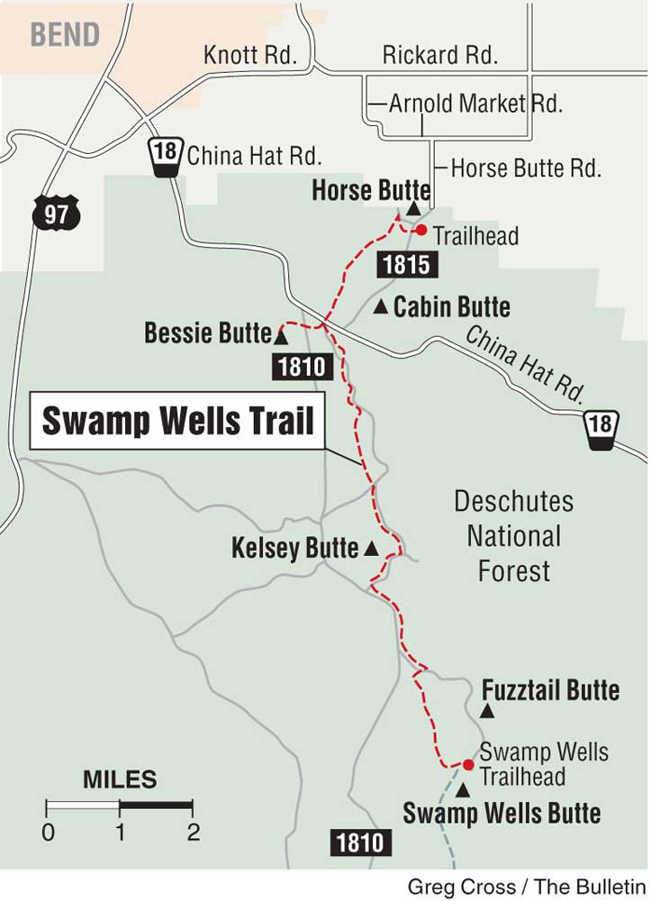
The Swamp Wells Trail southeast of Bend is a good spot to find some autumn solitude on a half-day ride on the High Desert.
Just before the ponderosa pine trees give way to the sagebrush, Bessie Butte rises above the terrain off China Hat Road. Sure, the area is more popular for shooting practice than it is with mountain bikers, but that doesn’t mean it is not a good place to ride.
Last week I drove southeast down China Hat Road and parked at the Bessie Butte Trailhead, where I eyed some hikers ascending the 4,768-foot butte.
I started out on the Bessie Butte Trail, and after riding about a quarter of a mile east I made a right on the Swamp Wells Trail headed south. (A left there would have taken me north to Horse Butte and more trails.)
Pine needles covered portions of the dusty trail as it meandered through a ponderosa forest. Some rain and frost will only improve the trail conditions this fal
I was all alone for the entire ride. Swamp Wells, which runs all the way to Newberry Crater more than 20 miles to the south, seems to be sort of an ignored trail among Central Oregon mountain bikers.
From Bessie, the Swamp Wells Trail is a gradual climb toward Kelsey Butte, about 5 miles to the south. Such a moderate climb is good for mountain bikers of all skill levels. A few rocky sections add in some technical challenges, but they are few and far between.
The Swamp Wells Trail stays in the trees until the tough climb up Kelsey Butte, where it leads to sprawling views of the vast forest and High Desert.
As I continued through the forest, getting closer to Kelsey Butte, the trail became steeper and steeper. Eventually it turned into a seriously challenging climb, but one well worth the effort.
The trail, with a couple of switchbacks, led me the viewpoint about halfway up Kelsey Butte. From that perch, I could see a significant number of Cascade peaks to the west and north: Mount Bachelor, Broken Top, the Three Sisters, Mount Jefferson and Mount Hood. To the east were the Badlands and Horse Ridge.
Closer to me were the myriad buttes dotting the area off China Hat Road: among them Coyote Butte, Horse Butte and Cabin Butte. I glanced back at Bessie Butte and down at the forest through which I had just ridden.
After wrapping around the base of 5,372-foot Kelsey Butte, the Swamp Wells Trail continues south past many other buttes all the way to the Newberry Crater Rim Trail.
After the trail descended sharply down the other side of Kelsey Butte, I rode a couple of miles deeper into the Deschutes National Forest before deciding to turn around and head back to Bessie to make for about a 14-mile out-and-back ride.
The downhill return was fast and flowing as I weaved through the forest along the still-sandy singletrack. I made it back to the Bessie Butte Trailhead in maybe half the time it took riding out to Kelsey Butte.
Returning to the trailhead after three hours of riding, I had yet to see another mountain biker, hiker, or horseback rider.
Much longer loops are available via the Swamp Wells Trail, which connects with both the Coyote Loop and Arnold Ice Cave trails southeast of Kelsey Butte.
Those trails will become less and less dusty as fall — which officially begins Thursday — takes hold in Central Oregon, providing mountain bikers with premium conditions on some of the best singletrack in the Northwest.
— Reporter: 541-383-0318,
mmorical@bendbulletin.com


Best of the Best of Bend 2025

-
eEdition

-

-
Go! eEdition