Santiam Pass offers a bounty of winter activity
Published 12:02 am Wednesday, January 18, 2017
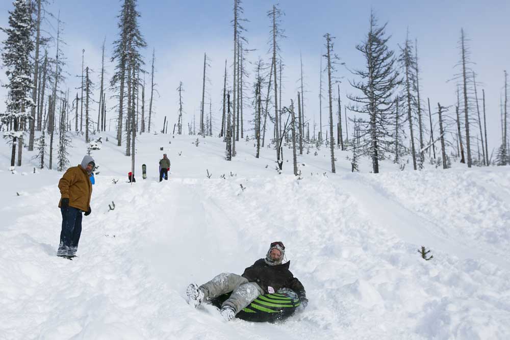
- Jayden Harrison, 14, sleds down the large hill at the Santiam Sno-park at McKenzie Bridge. The Asay and Gilhuber families drove to the park from Eugene for some fun in the snow on the second day of the new year.(Molly J. Smith/The (Salem) Statesman Journal)
SANTIAM PASS — Winter has arrived in Oregon’s mountains.
As such, it’s time for skiers, snowshoers, snowmobilers and sledders to find powdery fun at Santiam Pass’ collection of sno-parks.
A seasonal permit of $25 will give you access to 11 different parks, along with the miles of trails they provide access to.
Each park is different. Some, like McCoy, are havens for snowmobilers. Others, like Maxwell, cater to snowshoers looking for scenery. Santiam is the place for sledding, while Ray Benson can’t be beat for cross-county skiing.
There is, in a nutshell, something for everyone.
Here’s a short breakdown, ranked from lowest to highest elevation, of what each sno-park offers. The best way to navigate sno-parks’ numerous trails is to stop at Detroit Ranger Station and pick up a Santiam Pass winter recreation map. Call ahead to check hours: 503-854-3366.
(Always be prepared for winter conditions when driving in the mountains).
Maxwell Sno-park
In a nutshell: A favorite for snowshoers and cross-country skiers, with 360-degree mountain views, two snow shelters and a wide collection of well-marked trails ranging in difficulty
Elevation: 3,700 feet
Activities: Skiing, snowshoeing
Trails: Seven trails totaling 22.8 miles
Difficulty: Easy to most difficult
Shelters: Mountain View Shelter (on Mountain View Loop) and South Maxwell Shelter (on South Maxwell Loop)
Amenities: Bathrooms
Usage: Medium to heavy
Big Springs Sno-park
In a nutshell: Wooded snowshoe routes that lead all the way to Lava Lake, with snowmobile access to a 40-mile network of trails
Elevation: 3,700 feet
Activities: Skiing, snowshoeing, snowmobiling
Trails: Five trails of 15.8 miles for skis/snowshoes; 40 miles of snowmobile trail access
Difficulty: Easy to most difficult
Shelters: None
Amenities: Bathrooms
Usage: Light
Potato Hill Sno-park
In a nutshell: Old-growth forest and panoramic views of Three Fingered Jack and Mount Washington near the top of namesake hill, on a popular and fairly easy snowshoeing route
Elevation: 4,200 feet
Activities: Skiing, snowshoeing
Trails: Two trails totaling 6.2 miles
Difficulty: Easy to more difficult
Shelters: None
Amenities: None
Usage: Light
Santiam Sno-park
In a nutshell: Best-known for the “snow play” area, which includes a sledding/tubing hill popular with families. Also provides access to Pacific Crest Trail and the backcountry area around Three Fingered Jack.
Elevation: 4,800 feet
Activities: Skiing, snowshoeing, tubing
Trails: One trail of 1.2 miles that connects to the Pacific Crest Trail into the Mount Jefferson Wilderness. Not marked beyond wilderness boundary.
Difficulty: Easy
Shelters: None
Amenities: Bathrooms
Usage: Heavy, mostly among sledders.
Ray Benson Sno-park
In a nutshell: The largest and best-known sno park on Santiam Pass, with views of the surrounding mountains and a large network of trails. The favorite destination of cross-county skiers.
Elevation: 4,800 feet
Activities: Skiing, snowshoeing, snowmobiling, mushing (sled dogs)
Trails: Eight trails totaling 67.7 miles, with snowshoeing/skiing (six), snowmobiling (three), mushing (one)
Difficulty: Easy to most difficult
Shelters: North Blowout Shelter and South Blowout Shelter
Amenities: Two restrooms, warming hut, orientation maps, staging area with snub posts for sled dogs
Usage: Heavy
Ikenick Sno-park
One of the least-known snowshoe routes on Santiam Pass begins at this park.
Ikenick Sno-Park, just off Highway 126, sits at the fairly low elevation of 3,200 feet. Because of that, it hasn’t gotten much snow since 2011 and consequently hasn’t had many visitors.
That finally changed last year and has continued into this season — the snowiest since 2001.
The Isaac Nickerson Loop is 4.4 miles and climbs 472 feet, passing multiple viewpoints of the Cascade Range and dipping into snowy forest. It’s well-marked and easy to follow.
Other Santiam Pass sno-parks
Corbett Sno-park: Nine ski/snowshoe trails, located east of Santiam Pass and Hoodoo Ski Area in Deschutes National Forest off Highways 22/20; elevation 4,200
Little Nash Sno-park: One trail each for skis and snowmobiles, located 1 mile west of Santiam Junction on Highways 126/20; elevation: 3,800
Lava Lake Sno-Park: Four easy ski/snowshoe trails totaling 4.5 miles, with one snowmobile route of 25 miles, 4 miles west of Santiam Junction on Highway 20; elevation 3,500
Lava Lake Sno-Park: Four ski/snowshoe trails, one for snowmobiles, 4 miles west of Santiam Junction on Highway 20; elevation 3,500
Tombstone Sno-Park: Two ski/snowshoe trails, one musher trail 11 miles west of Santiam Junction on Highway 20; elevation 4,200


Best of the Best of Bend 2025

-
-
-