Fire update: I-84 closed in the Columbia River Gorge
Published 4:31 am Tuesday, September 5, 2017
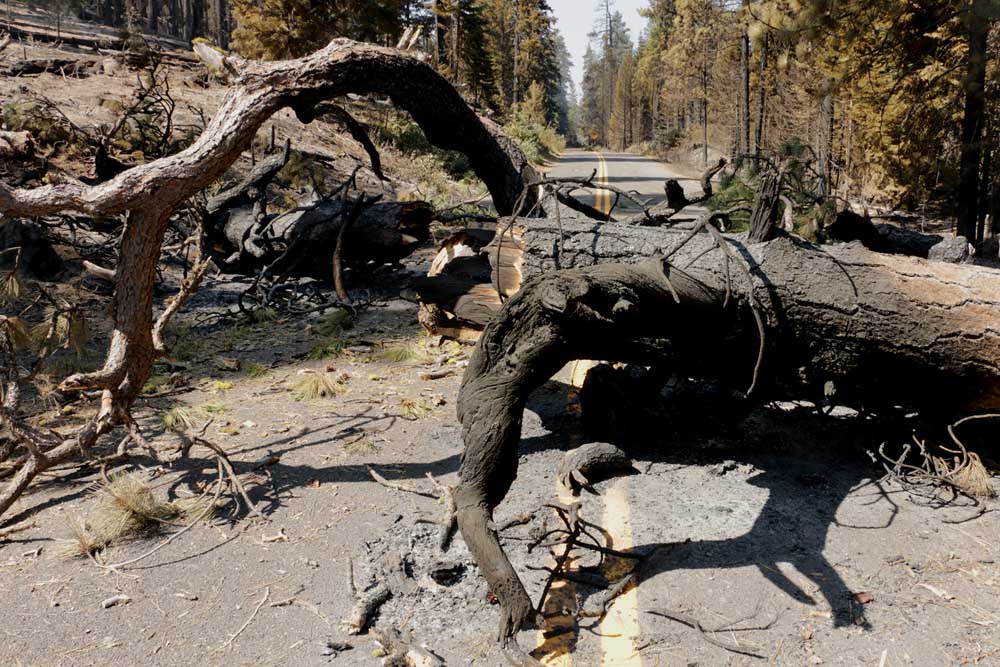
- A tree burned in the Milli Fire fell across the McKenzie Pass Highway, causing a closure of the road one mile west of Sisters. (Peter Murphy/submitted photo)
Updated at 6:55 p.m. Monday:
Interstate 84 has been closed in the Columbia River Gorge because of the Eagle Creek Fire, according to the Oregon Department of Transportation. All westbound traffic must leave the highway at exit 62 in Hood River, and all eastbound traffic must leave at exit 35 at Ainsworth State Park and the Historic Columbia River Highway. The highway will reopen when agencies involved in fighting the fire consider it safe to do so. Go to TripCheck.com for the latest information.
Updated at 10:30 a.m. Monday:
Fire crews began work near Elk Lake on Sunday to reduce fuels around roughly 40 recreation cabins and the Elk Lake guard station. They also have stationed hoses and pumps near structures. The Nash and Separation fires continue to burn in steep terrain within the nearby Three Sisters wilderness. The fires have the potential to move in any direction quickly, according to the Monday update from the Northwest Incident Management Team, and firefighters are making plans for the blaze to move out of the wilderness to the southeast toward the Elk Lake area.
The Deschutes County Sheriff’s Office has imposed a level-two evacuation notice for the areas around Elk Lake and Hosmer Lake. A level-one evacuation notice has been imposed on areas surrounding Lava Lake and Little Lava Lake. People within a level-two evacuation area, the more urgent of the two, should be prepared to leave at a moment’s notice. Current maps, including evacuation areas, can be found here.
Meanwhile, the Milli Fire, burning west of Sisters, is roughly 60 percent contained. The evacuation level for the Crossroads subdivision, Edgington Road, Remuda Road, Peterson Burn Road, Wildwing and Three Creeks Road residences has been reduced to level one. Also at level one are the following areas: Tollgate, Black Butte and the area between state Highway Route 242 and U.S. Highway 20, west of Cold Springs cutoff.
A public meeting has been scheduled for 5 p.m. on Sept. 5 at Sisters High School. Fire managers and local agency leaders will be present to answer questions.
Updated at 12:51 p.m. Sunday:
The Nash Fire burning northwest of Elk Lake could threaten popular recreation sites along the Cascade Lake Highway within three days, fire managers said Sunday.
In a midday Sunday update, fire managers projected that if not checked, the fire could be ready to jump the Cascade Lakes Highway within 72 hours. If not stopped at the highway, the fire could reach Lava Lake, the Elk Lake Resort area, and the Mt. Bachelor ski area.
Now 3,312 acres, the lightning-sparked Nash Fire is burning on the southwest side of South Sister. Those in the Elk Lake and Hosmer Lake areas are under a Level 2 evacuation notice, and should be prepared to leave the area immediately if ordered.
Meanwhile, the Milli Fire west of Sisters has been declared 50 percent contained after burning 22,527 acres. Evacuation notices were relaxed Sunday for those living near the Milli Fire.
Residents of the subdivisions of Crossroads, Edgington/Remuda, Wildwing and the Peterson Burn Road area went from a Level 2 evacuation notice to a Level 1. Residents should still be ready for a potential evacuation, as should those living along Three Creeks Road south of the Brooks Scanlon Logging Road.
Fire managers are expecting an extended battle against the Milli Fire, with full containment not projected until Oct. 1.
Fires burning throughout the northwest are contributing to heavy smoke in many areas around Central Oregon – state Department of Environmental Quality monitoring stations were reporting “unhealthy” and “very unhealthy” conditions in Sisters and Bend on Sunday, with the air slightly clearer in Prineville.
Updated at 7:30 p.m. Saturday:
U.S. Highway 20 just west of the Santiam Pass has been opened to traffic in both directions, day and night. Traffic at this spot had been limited to one lane as the result of a nearby wildfire, and a pilot car had been used to usher cars through the fire area. Though two-way traffic has been resumed, the Oregon Department of Transportation will remain on the scene around the clock in case firefighting efforts require a change in traffic patterns, according to state transportation officials.
Meanwhile, the Central Oregon Interagency Dispatch Center has released updates on a handful of local fires.
The Nash Fire is still burning in the Willamette National Forest about six miles north of Elk Lake, and fire personnel are preparing for the fire to move to the southeast. A level-two evacuation notice remains in effect for the Elk Lake and Hosmer Lake areas, and a level one notification remains in effect for areas surrounding Lava Lake. The Cascade Lake Highway remains open in both directions. People in areas under a level two evacuation notice, the more urgent of the two, should be prepared to leave at a moment’s notice. For more information about the Nash Fire, go here.
The Milli Fire, burning west of Sisters, covers roughly 22,700 acres and is about 44 percent contained. Level one and level two evacuation notices are still in effect for residential areas outside Sisters. For more information about the Milli Fire, go here.
Updated 1:06 p.m. Saturday:
Hot, dry, unstable weather conditions prompted the National Weather Service to issue an urgent Red Flag Warning for Central Oregon from noon to 10 p.m. Saturday.
Any fires that develop will likely spread quickly, the weather service said. Outdoor burning is not recommended.
The warning includes Bend, Redmond, Prineville and Madras, where humidity levels will range from 5 to 15 percent.
An air quality alert is also in effect for much of the region as well, due to wildfires.
Unhealthy levels are expected through Tuesday in Prineville, Post, Paulina, Bend, Redmond, Sunriver, Sisters, La Pine, Brothers, Madras, Warm Springs and Culver, the weather service said.
Updated 3:09 p.m. Friday:
Increased smoke Friday in Sisters and Black Butte Ranch is expected from 20 to 30 acres of interior burning on the Milli Fire, but the fire still sits at 44 percent containment, as reported Wednesday evening by fire management officials.
“People are seeing a lot more smoke but it’s not a threat to containment lines,” said Susie Heisey, public information officer for Central Oregon Interagency Dispatch Center.
The Milli Fire has burned 22,718 acres and remains at 44 percent containment. Evacuations remain in place in areas south and west of Sisters for residents to be ready to evacuate at a moment’s notice, Heisey said.
The McKay fire east of La Pine remains at 50 percent containment as reported Thursday afternoon as crews continue mopping up hot spots within the containment lines.
“Things are looking pretty good for both McKay and Milli,” Heisey said.
The rugged terrain surrounding the Nash fire has prevented crews from gaining ground as it has burned 2,448 acres in the Willamette Area of south Sisters and is not contained.
“Because of the location it limits crews’ accessibility,” Heisey said. “But they are flying over and doing air drops.”
People living near Elk Lake and Lava Lake are still being told to be ready to evacuate.
Delays in Santiam Pass are still expected due to the Potato Hill Fire. The 165-acre fire is close to U.S. Highway 20, reducing traffic to a one-lane road led by a pilot car, but the pass remains open.
People are reminded to expect delays and use headlights when traveling through Santiam Pass, Heisey said. Crews, bulldozers and engines continue to make significant progress.
Updated 11:14 a.m. Friday:
Air quality throughout Central Oregon is expected to reach unhealthy levels over the Labor Day weekend, according to the Oregon Department of Environmental Quality, which issued an alert late Friday morning.
Wildfires in the region and high temperatures — 101 degrees in Redmond and 97 degrees in Bend, Saturday and Sunday — are to blame, according to the National Weather Service, which posted an air quality alert through noon Tuesday.
“Areas near local wildfires could see unhealthy or worse air quality readings,” the weather service said in an online post. “Conditions are expected to remain at least unhealthy for sensitive groups into early next week, as smoke lingers in a stagnant air pattern.”
Affected areas include Prineville, Post, Paulina, Bend, Redmond, Sunriver, Sisters, La Pine, Brothers, Madras, Warm Springs and Culver, the weather service said.
The smoke can cause burning eyes and a runny nose as well aggravate heart and lung diseases. The weather service advised the public to limit outdoor activities and keep children indoors if it is smoky.
Updated 9:03 a.m. Friday:
Wildfires in the region will make Labor Day weekend travel between the Willamette Valley and Central Oregon difficult for drivers, according to the Oregon Department of Transportation, which issued an advisory Friday morning.
Long delays should be expected because firefighting agencies are cutting burning trees, dropping water from helicopters and moving equipment, especially along U.S. Highway 20.
Road closures and delays caused by fires continue in areas around Oregon Route 22 and U.S. Highway 20, from Detroit Lake through Santiam Pass and to Sisters.
There has been so much impact from firefighting on the busy U.S. Highway 20 route over Santiam Pass, that state transportation officials are using a pilot car to direct two-way traffic for 1.5 miles along the highway. Motorists should expect the pilot car between 7 a.m. and 7 p.m. Both lanes could be open overnight, but a pilot car could be used at any point, transportation officials said.
Highway delays are expected to continue for several days and fire behavior will likely be affected by soaring temperatures. Motorists are asked to be careful when driving through or parking near dry brush because hot exhaust pipes often start fires, transportation officials said.
The National Weather Service is predicting temperatures in the 90s beginning Friday, and topping out with highs of 97 Saturday and Sunday in Bend.
Updated 6:02 p.m. Thursday:
As of late Thursday afternoon, the Central Oregon Interagency Dispatch Center had few updates on wildfires. A number of containment levels, evacuation notices and area closures remained unchanged from Wednesday, according to Susie Heisey, a public information officer with the dispatch center.
The Nash Fire, burning on the west side of the Cascades, has been active over the last couple days, Heisey said. The wildfire had burned 2,250 acres by Thursday afternoon, about 5 miles west of Cascade Lakes Highway in a southeast direction, Heisey said.
The McKay Fire, burning east of La Pine, was 50 percent contained Thursday afternoon. An infrared view of the fire Wednesday night showed a few areas of isolated heat spots but all within the fire line. Crews planned to continue mopping up that fire Thursday, Heisey said.
Crews working the Milli Fire near Sisters have been successful holding containment lines, according to Heisey. That fire, which has burned 22,190 acres, was 44 percent contained Thursday afternoon, the same level of containment reported Wednesday evening.
Though the acreage of the Milli Fire increased, those added acres burned are within the fire lines, and the increase comes from backburning, Heisey said. Crews backburned near a piece of private land surrounded by Forest Service lands to lessen intensity of the fire there, she said.
Though much smaller compared with other fires in Central Oregon, the 50-acre Potato Hill Fire, burning south of Lost Lake, is causing delays at Santiam Pass. There, because of the fire’s proximity to the road, only one lane of U.S. Highway 20 is open. Eastbound and westbound lanes are taking turns using the westbound lane, following a pilot car, according to the Oregon Department of Transportation.
Updated 3:30 p.m. Wednesday:
The U.S. Forest Service wants to remind the public that evacuation notices announced Wednesday are still in place for residents who live near a number of Central Oregon wildfires.
• Nash Fire: Notices for people living near Elk Lake and Lava Lake to be ready to evacuate remain in place, according to Susie Heisey, a public information officer with the Central Oregon Interagency Dispatch Center.
• Milli Fire: Notices for residents in areas south and west of Sisters to be ready to evacuate remain in place, Heisey said.
• McKay Fire: While there are no evacuations associated with the McKay Fire, the Forest Service is asking the public to stay out of the fire area — located between Forest Service roads 9735 and 9720.
Updated 1:02 p.m. Thursday:
As Labor Day weekend nears, Oregon Department of Transportation officials are reminding people to be aware of road closures and delays in making their travel plans.
A few highway closures persist around Central Oregon due to wildfires. The McKenzie Pass Highway is closed to westbound traffic 1 mile west of Sisters because of the Milli Fire. That highway is also closed 1 mile east of the intersection with Highway 126.
Peter Murphy, a Bend-based state transportation spokesman, was at the McKenzie Pass Highway closure a mile west of Sisters Thursday afternoon. There, a tree burning in the Milli Fire had fallen across the road.
After clearing the tree, the department will also have to check if there was damage to the highway that needs to be repaired.
To avoid the closures on McKenzie Pass Highway, drivers need to take U.S. Highway 20 — but as Murphy pointed out, that’s the way most people travel anyway.
The other closure on the McKenzie Pass Highway is due to the behavior of the Milli Fire — the area is too dangerous for people to drive through, he said.
There is also a delay at U.S. Highway 20 at its intersection with state Highway 22. Eastbound and westbound traffic is being flagged through the westbound lanes with a pilot car because of the Potato Hill burning, which has burned 50 acres south of Lost Lake. Drivers there should expect about a 2-hour, 20-minute delay, Murphy said.
Murphy wants travelers to be aware of delays and closures by paying attention to conditions and checking the status of roads ahead of time. Travelers can visit tripcheck.com for up-to-date information on closures and delays across Oregon.
Updated 11:56 p.m. Thursday:
A few highway closures persist around Central Oregon due to wildfires, according to the Oregon Department of Transportation.
McKenzie Highway is closed to westbound traffic 1 mile west of Sisters because of the Milli Fire. That highway is also closed 1 mile east of the intersection with Highway 126.
Updated 3:20 p.m. Wednesday:
The Deschutes County Sheriff’s Office elevated its evacuation notice for locations around Elk and Hosmer lakes. Residents were told to be prepared to evacuate at a moment’s notice.
The notice is on account of the area’s proximity to the Nash Fire, burning on the Willamette National Forest to the west of the Cascade Lakes Highway. Currently about five miles from Elk Lake, the Nash Fire has burned an estimated at 553 acres.
Residents around Lava Lake and Little Lava Lake have been told to be ready to leave.
Updated 1:43 p.m. Wednesday:
In Bend, a number of events were canceled or postponed Wednesday due to the smoke.
Tumalo Creek Kayak & Canoe canceled its Pickin’ and Paddlin’ event, an outdoor concert and boat demonstration fundraiser for the Bend Paddle Trail Alliance. The kayak and canoe shop plans to reschedule the event.
Worthy Brewing Company canceled its live music performances Wednesday and Bend Park & Recreation District canceled several programs, including youth sports, adult pickleball, tennis and softball. The park district also closed the outdoor pool at Juniper Swim & Fitness Center and rental stands at Riverbend Park were closed, according to the park district.
Updated 12:27 p.m. Wednesday:
Poor air quality in Bend is expected to continue into next week according to the National Weather Service Pendleton office.
John Peck, a meteorologist there, said he doesn’t expected conditions next week will be quite as bad as they are in Bend Wednesday, but a high pressure system coming this weekend will cause light winds and the air to stagnate. That stagnant air will likely mean air quality will stay “less than optimal” at least into early next week.
In addition to the pressure system, air quality conditions depend on fire behavior in the coming days, Peck said.
Because the level of air pollution is “harmful to all,” Bend Fire Battalion Chief Dave Howe offered a few reminders from the Deschutes County Health Department on how people can minimize the effects of the smoke in a news release.
Among them, the health department recommended people avoid areas with the highest concentrations of smoke, keep indoor air as clean as possible, avoid strenuous activity outside and reduce time spent outdoors in general.
The department also reminded people with asthma or other respiratory issues to follow their breathing management plans and stay in contact with their healthcare providers.
Although people may be seen using paper or dust masks around Bend, those don’t offer reliable protection from smoke: An N95 mask, found at building supply and hardware stores, offers some protection but “may increase breathing effort,” the release said.
In Redmond, visibility is clearly diminished due to the smoke, but Redmond Municipal Airport Director Zachary Bass said it hasn’t led to any groundings or delays at the airport.
“We are at about a three-fourths-mile visibility,” he said. “We don’t see effects until a half-mile.”
Bass said word from the air control tower is that visibility is expected to improve, so he doesn’t anticipate delays in the near future.
Meanwhile, because the Milli Fire became intensified on private land in the fire perimeter on Tuesday afternoon, crews worked through the night backburning the area, trying to keep the fire down, according to a news release from the Central Oregon Interagency Dispatch Center. Crews will continue to work on that area on Wednesday.
During a short period of clear skies Tuesday, a helicopter flew over the Milli Fire to look for any potential spot fires outside the fireline, but didn’t find any. The south side of the fire was burning down slope and is expected to burn to McKenzie Highway Wednesday. The southwest corner of the fire is still actively burning and putting up a smoke column, but because it’s beginning to burn into the area of the Pole Creek Fire from 2012, it could start slowing down, according to Stacy Lacey, a public information officer for the Milli Fire.
In contained areas on the southeast side of the fire, crews are making good progress rehabilitating the land to a more natural state using dozers, excavators and wood chippers.
Some communities around the Milli Fire are still under low-level evacuation notices. The Tollgate subdivision and areas between McKenzie Highway and U.S. Highway 20 west of Cold Springs Cutoff (including Black Butte Ranch) are warned to be ready for a potential evacuation notice. The Crossroads subdivision and residences at Edgington Road, Remuda Road, Peterson Burn Road, Wildwing and Three Creeks Road should be set for a potential evacuation.
High temperatures and low relative humidity are contributing to the smoke seen in Central Oregon, the release said.
Updated 9:43 a.m. Wednesday:
The McKay Fire burning east of U.S. Highway 97 near McKay Butte had burned 1,364 acres, according to a release from the Central Oregon Interagency Dispatch Center. Firefighters made a line around the entire fire Tuesday night and will work on holding and improving those lines Wednesday. Crews will also look for any spots across the fire line, the release said.
Officials are asking the public to stay out of the fire area between Forest Service roads 9735 and 9720. More than 100 people are working on the McKay Fire.
Although aviation resources are available, the ability to use them may be limited because of visibility.
Due to the Nash Fire burning in the Willamette National Forest, the Deschutes County Sheriff’s Office has warned those in the Elk Lake Area to be ready to evacuate. Those areas include: Elk Lake Resort, Elk Lake campground, Point campground, Little Fawn campground, Mallard Marsh campground, Sunset View Day Use Area, Beach Day Use Area and Quinn Meadows Horse Camp. Cascade Lakes Highway is still open.
Those seeking more information on those evacuation notifications can call the Deschutes County Sheriff’s Office non-emergency line at 541-693-6911.
Tuesday, two fires south of Lava Butte triggered the evacuation of the Lava River Cave and Lava Lands Visitor Center in the Deschutes National Forest. Containment lines there held overnight and crews will continue to mop up those fires Wednesday. Those visitor facilities have reopened to the public.
Updated 8:57 a.m. Wednesday:
The smoke in Central Oregon is not coming only from the Milli Fire near Sisters, according to a press release from the Deschutes National Forest. There are 16 large fires or fire complexes burning across Oregon, and fire experts expect to see continued growth on many of these thanks to current and expected weather conditions, according to the Forest Service. As a result, smoke is expected to persist in the area for several days.
Anyone with questions about regional fires can call the Northwest Large Fire information number at (503) 808-2764 or visit the center’s website. The NW Large Fire Map can be found here, according to the Forest Service.
Anyone with questions about smoke can visit the Department of Environmental Quality’s Air Quality website, the Deschutes County Public Health website or the Oregon smoke blog.
For information about seven-day significant fire potential, the Forest Service recommends people go here.
Updated 5 a.m. Wednesday:
One lane has been reopened on U.S. Highway 20 between mileposts 75 and 88, but travelers crossing the Santiam Pass Wednesday morning should still expect delays. According to the Oregon Department of Transportation, two-way traffic is being flagged and ushered through the stretch of highway with a pilot car.
Highway 20 was closed Tuesday afternoon due to a wildfire. The highway was closed to westbound traffic at Santiam Pass, and to eastbound traffic at Santiam Junction.
Meanwhile, the Deschutes County Sheriff’s Office issued a level-one notice for the area around Elk Lake Tuesday due to the Nash Fire, which is burning in the Willamette National Forest. A level-one notice indicates that people should be prepared for potential evacuation and monitor emergency service websites.
According to a Tuesday press release from the Central Oregon Interagency Dispatch Center, the area affeced by the evacuation notice includes Elk Lake Resort, Elk Lake Campground, Point Campground, Little Fawn Campground, Mallard Marsh Campground, Sunset View Day Use Area, Beach Day Use Area and Quinn Meadows Horse Camp.


Best of the Best of Bend 2025

-
-
-