Mountain Bike Trail Guide: Smith Rock trails
Published 7:15 am Thursday, September 14, 2017
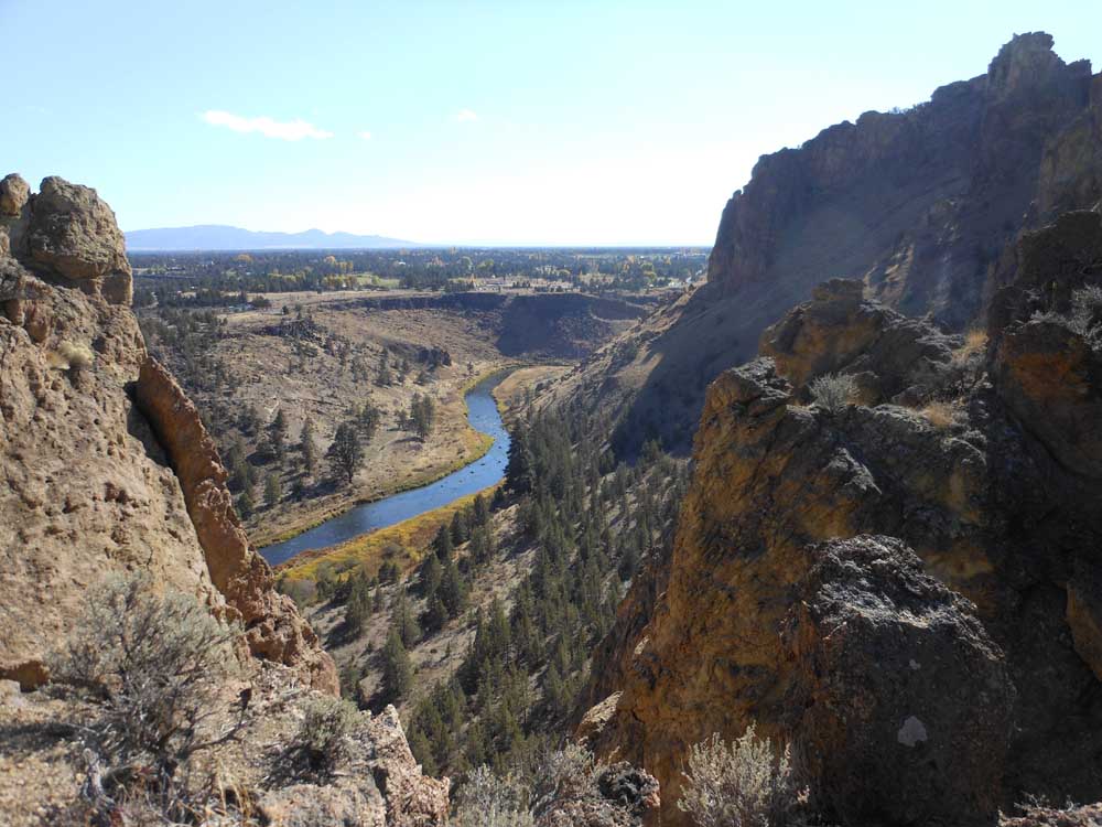
- Many hiking trails in Smith Rock State Park lead to dramatic viewpoints.Mark Morical / The Bulletin
TERREBONNE —
Smith Rock State Park is home to one of my favorite pieces of Central Oregon singletrack.
The problem is, the climb to reach said singletrack is so grueling it can leave mountain bikers seeing stars.
Burma Road is a dirt double track that rises sharply along a barren hillside just outside the park. Drivers on U.S. Highway 97 can see Burma carved into the hill.
While ascending Burma is a daunting task on a mountain bike, once at the top, riders have access to some unique trails, including the Gray Butte Trail. The thrilling side-hill singletrack that leads to Gray Butte offers sprawling views of the Crooked River National Grassland and the Cascade Range.
So it was with the promise of riding that trail that I slogged my way from the Wolf Tree Trail in the main area of the park up to Burma Road last week on a bright fall day at Smith Rock. The few times I had ridden up Burma, I never made it to the top without walking my bike at least part of the way. This time, I walked the middle section of the road before getting back on my bike to pedal the rest of the way to the top.
At the top, riders and hikers are treated to a bird’s-eye view of Smith Rock that by itself is nearly worth the effort. And the trails to come make it completely so.
From the top of Burma Road, bikers can connect to the Gray Butte Trail leading toward the butte. Several options exist, including completing the Cole Loop to the east or the Burma Loop to the north. Both rides skirt the summit of Gray Butte.
My plan was to ride the Gray Butte Trail out and back as far as I desired, then take the Summit Trail down to the River Trail, which would lead me back through the park and complete the loop.
The Gray Butte Trail cuts along the hillside and is fast, flowing and fun. Keeping both eyes on the trail is a must, because it runs along a steep drop-off to the northwest — probably not steep enough to fall to your death but definitely cause for injury if you were to veer off the narrow singletrack. If riders want to take in the view, it is best to stop first.
I recall a fellow mountain biker referring to the Gray Butte Trail as having some serious “pucker factor.”
So I puckered up and cruised along the trail, which was in prime fall condition after recent rainfall. (Mountain biking at Smith Rock and Gray Butte is typically best in the fall and winter.)
Where the side-hill section ends, bikers can connect to the Cole Loop Trail or continue along the Gray Butte Trail.
I continued on the latter, and the trail became decidedly uphill and rocky. Still tired from the climb up Burma Road, I made the decision to head back the way I had come.
Back at the junction of the Gray Butte Trail and Burma Road, I turned onto the Summit Trail, a relatively new path of switchbacks that connects to the River Trail on the west side of the park.
The switchbacks are so sharp that I was forced to unclip from my pedals on most all of them, but I eventually made my way down, bouncing my tires fast along the trail and back into Smith Rock State Park.
After one left turn I suddenly found myself following the trickling Crooked River, with the prominent rock spire of Monkey Face rising ahead of me into the blue sky. I continued along the trail until it took me into the main climbing area.
There, mountain bikers should ride with caution and yield to hikers, as the area can become rather crowded.
Climbers hung tight to the rock walls and hikers meandered along the trail as I walked my bike in certain stretches.
I came across just one other mountain biker on the 12-mile, three-hour journey.
But this time of year it is worth the drive to take your bike out to Smith Rock and find some sweet singletrack, no matter how hard the climb to get there.
— Reporter: 541-383-0318,
mmorical@bendbulletin.com
Smith Rock/Gray Butte
Directions: From Bend, travel 22 miles north to Terrebonne. Turn right on Smith Rock Road for 1 mile. Turn left on Lambert Road. Follow this for about 1 mile and look for signs to the park. Park in the day-use area, and expect to pay a $5 parking fee.
Length: Loop options of 9 to 12 miles. The Burma Road Loop, starting at the main park trailhead, is 11.4 miles; the Gray Butte Loop, starting from Grasslands Campground, is 9.2 miles.
Rating: Technically intermediate, aerobically strenuous.
Trail features: A grueling climb up Burma Road, followed by thrilling, unique side-hill singletrack; sprawling views of the Crooked River National Grassland and the Cascade Range.
Season: Fall, winter, spring.
Contact: Visit oregonstateparks.org and search for Smith Rock State Park.
More guides can be found at bendbulletin.com/rideguide

Best of the Best of Bend 2025

-
-
-