7 summits that are quite modest — for Colorado
Published 12:00 am Thursday, April 5, 2018
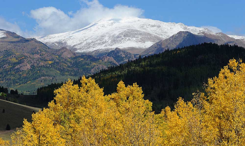
- A fresh coat of snow blankets 14,115-foot Pikes Peak near Victor, Colorado. Visible from Colorado Springs, this fourteener lords over other, more manageable peaks nearby — all of them worth the hype, and a hike.(Christian Murdock/Colorado Springs Gazette/TNS)
Mount Herman
9,063 feet, 2.2 miles round trip, 1,040-foot elevation gain from Trail 716 in Monument, Colorado
Trending
Mount Herman Road switchbacks high above Monument into parts of Pike National Forest west of Colorado Springs, Colorado, where families pitch tents for the weekend. Getting to the top of the most imposing mountain overlooking this side of Interstate 25 starts on an inconspicuous trail.
The post numbered 716 hides in the shrubs off the road. Start in the woods where a stream trickles on and wildflowers burst in summer. You’ll pass through meadows, aspen groves and rocky terrain to views of Palmer Lake and the Air Force Academy, with Pikes Peak to the south and Longs Peak visible to the north on a bluebird day. A fine reward for just 1 mile, however steep.
Blodgett Peak
9,426 feet, 7.8 miles round trip, 2,610-foot elevation gain from Blodgett Peak Open Space
Some mountains on this list require nothing more than an able, willing body. For this one in northwest Colorado Springs, you’ll need mettle and wit. Signs in the parking lot off Woodmen Road warn visitors of a “difficult and treacherous” climb. Hummingbird Trail begins innocently, taking users on gentle ridges to see the city and far-off plains. The ruggedness of National Forest land takes over, the path disappearing at times among fallen timber and boulders. A harsh hill with typically loose soil is Blodgett’s last test before her majesty.
Red Mountain
Trending
7,375 feet, 2.4 miles round trip, 1,035-foot elevation gain from Intemann Trail
Some opt for this trail rather than endure the nearby sufferfest that is the Manitou Incline. Red Mountain offers the solitude that the Incline does not, and the uphill workout isn’t half bad either. It’s not just the views that make the trek worthwhile. You’ll behold Garden of the Gods and the mountains wrapping the village on the way to the summit. History hides on the east-facing ridge: the concrete remains of a former tourist hangout.
Mount Muscoco
8,020 feet, 4.2 miles round trip, 1,284-foot elevation gain from North Cheyenne Canon Park
You can reasonably expect to not have to share the trail much on most of these mountains. Muscoco is different. It’s one of the most beloved destinations in one of the Springs’ most beloved outdoor hubs, and rightly so. The path eventually zig-zags through a boulder field before arriving to the clearing, where you’ll be among the birds soaring over the canyon. Listen for the rush of Helen Hunt Falls somewhere below.
Mount Rosa
11,499 feet, 3.5 miles round trip, 1,200-foot elevation gain from Frosty’s Park
The most popular way up one of the region’s most recognizable mountains begins above 10,000 feet, near the wide meadow where a prospector named Frosty once lived. You’ll need a four-wheel drive on Forest Road 379, the gnarly stretch off Gold Camp Road that leads to Nelson’s Trail, No. 672. Snow cover could make the path tough to follow, but friendly cairns are known to guide first-timers. The trail splits for No. 673, leading to the rocky top with panoramic vistas of peaks and valleys.
Raspberry Mountain
10,605 feet, 4.8 miles round trip, 1,500-foot elevation gain from Ring the Peak Trail
Most come to this area outside Divide for the Crags trail. Often overlooked is the trail before it on Forest Road 383, past the Rocky Mountain Mennonite Camp. Taking it will bring you above the granite beauties giving that popular place its name. The grander views will make you glad you chose the path less traveled. The summit route can be tricky to follow after initially aligning with Ring the Peak Trail. Be prepared to navigate old forest roads before the final push to paradise, with snow-capped ranges scraping the sky in every direction.
McCurdy Mountain
12,168 feet, 14 miles round trip, 3,900-foot elevation gain from Twin Eagles trailhead in Lost Creek Wilderness
McCurdy stands as the second-highest point in the Tarryall Mountains, and it stands to showcase the far-flung adventure offered below the state’s celebrated reaches above 14,000 feet. The Lost Creek Wilderness isn’t deemed high country and therefore doesn’t get a lot of attention. But famed mountaineer Gerry Roach considers Colorado Springs’ closest wilderness a Colorado treasure. McCurdy’s summit — “a rock wonderland,” he calls it — is a favorite of his across the 119,790 acres of stunning outcrops and awe-inspiring plateaus. Before embarking with your backpack and camping gear, do your research. Roach’s guidebook on the Lost Creek Wilderness recommends the McCurdy route from Twin Eagles Campground.
Marketplace

Best of the Best of Bend 2025

-
eEdition

-

-