A hike to explore the Owyhee wilderness
Published 12:00 am Thursday, June 28, 2018
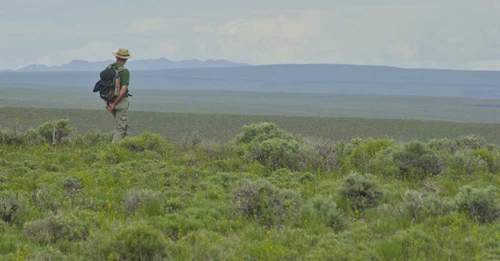
- A view in the Owyhee.
LITTLE JACKS CREEK WILDERNESS, Idaho — Micah Lauer knows how unforgiving and inaccessible Idaho’s Owyhee wilderness can be. He spent three days in May running and hiking across the entire county.
The middle school science teacher knows how underappreciated the sagebrush steppe is.
“This is truly an embodiment of the West,” he said during a recent hike through Perjue Canyon. “It’s the only place in the world where this type of ecosystem exists.”
The Perjue Canyon trail — a multi-year project by the Bureau of Land Management, Idaho Trails Association and other volunteer groups — should help more people explore the Owyhee Canyonlands. It’s easily accessible off the well-maintained Mud Flat Road with moderate elevation gain, surprising trees, a homestead, stunning wildflowers and wildlife encounters.
The trail leads into the Little Jacks Creek Wilderness, one of six areas of Owyhee County designated as wilderness in 2009, and follows the West Fork Shoofly Creek. Our out-and-back hike covered 8 miles round trip with 750 feet of elevation gain, but you could get a similar experience in 5 to 6 miles.
The ITA, a volunteer trail maintenance organization, plans to spend National Trails Day on Saturday working the Perjue Canyon trail for the eighth straight year. The idea is for the trail to “showcase the wilderness,” said Matt Clark, who serves on the ITA advisory board and has worked on the trail. The majority of the existing trail was created by livestock use in the canyon that began in the late 1800s, according to the Bureau of Land Management. Homesteads were established bases for cattle and sheep operations.
“It’s what it was like in the Wild West,” Clark said. “It’s rough country. It’s hot, and then you walk into this canyon where there’s a canopy of aspens, alders and wildflowers. It’s kind of a jungle out in the middle of the desert. It always surprises me.”
Perjue Canyon is named after Frank Perjue, whose homestead is one of the hike’s highlights. The old wooden cabin still has four walls but lacks a roof. Perjue was married to Ethel Foss in Elmore County in 1918, according to Ancestry.com. The trail begins as an old two-track road that the ITA is trying to convert to single-track trail by filling one side with debris cleared from the trail.
When the ITA began working on the trail, the sagebrush was so thick hikers would have struggled to get past the sign that marks the entrance to the wilderness area.
Hikers cross a rock scree field shaped into a trail, a walkway has been cut through the aspen grove and barbed wire has been cleared around the Perjue cabin.
“We’ve been cutting our way through for a long time now,” Clark said. “It was almost impassable when we first started.”
The long-term vision is to clear the trail for about 6 miles, which would connect to the Shoofly cutoff road and allow for one-way hikes if you have two vehicles. The Poison Creek picnic area, which is 1.7 miles before the Perjue Canyon trailhead, provides a scenic spot with picnic tables, fire pits and a vault toilet if you want to hang out after the hike.
Lauer plans to return to Perjue Canyon, perhaps with his family. He was impressed with the wildflowers in the canyon — including multi-colored lupines, red columbine and paintbrush. He shares images of the Owyhees on his Instagram account, sagebrushsteppe.
“This is an amazing part of the state to truly get out there and not see people,” Lauer said, “And to see some really amazing riparian habitat like in the bottom of this canyon, where you come down off the uplands and all of a sudden you’re in a lush streamside area and there’s wildflowers and tall trees and willow and wild roses. It’s just a really neat place to connect with nature with a different type of experience than going up into the mountains. It’s pretty accessible, and there’s a lot of stuff out here to explore that’s really lightly used.”


Best of the Best of Bend 2025

-
-
-