Hiking Black Butte
Published 12:00 am Friday, June 29, 2018
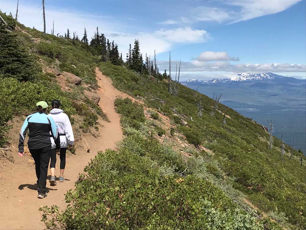
- Hikers approach the summit of Black Butte with cloud-covered Mount Jefferson in the background.
As trails with peak views go, hikers might get some of the most bang for their buck along the path to the summit of Black Butte.
Black Butte is not necessarily an incredibly demanding or spectacular hike deep in the mountains, but it is quite popular. And it is an ideal way to kick off the summer hiking season here in Central Oregon.
Hikers on the 2-mile route up Black Butte can see a variety of Cascade mountain peaks from the trail above the tree line and from the 6,436-foot summit, including Mount Jefferson, Three Fingered Jack, Mount Washington, the Three Sisters and Broken Top.
I set out last week for the Black Butte trailhead, looking for a fairly short but steep hike — it’s a 1,600-foot climb to the top — that could serve as a nice warm-up for more grueling hikes yet to come this summer.
The hiking season is getting an early start this year after a winter of relatively little snowfall. Snow lines and access are about a month ahead of a normal season, according to the U.S. Forest Service conditions report for the Deschutes National Forest. All low-elevation trails and most mid-elevation trails were melted out by early to mid-June, but patchy to deep snow remains on high-elevation trails.
Forest Road 1110 to the upper trailhead at Black Butte was rough and slow-going, but I made it with no problem after about a one-hour drive from Bend.
The 4-mile (round trip) hike started in the trees and climbed steeply through old-growth ponderosa pines. Eventually, the trees thinned out and I was treated to a dramatic view of Mount Washington and the Three Sisters. I noticed Black Butte Ranch and its emerald-green golf courses far below, nestled into the forest.
The dusty trail wrapped around the butte above the tree line to reveal views of Jefferson and the sprawling High Desert. As I approached the summit, I could see Green Ridge to the northeast and the Metolius River cutting through the thick forest to the north.
Commanding views could be seen in all directions from the summit, where only a few hikers lingered — though the trail and the summit can get crowded on summer weekends.
Resembling a dark symmetrical triangle from afar, Black Butte has long been a fire lookout site, as evidenced by the structures at its summit. According to a sign at the trailhead, it has served as a key fire detection point since 1910.
A faded, white cupola-style building from 1923 sits intact at the top, as well as the ruins of a 1934 tower. There is also a more modern 62-foot tower, built in 1995. Hikers are not permitted to climb or enter the structures.
According to the U.S. Geological Survey, Black Butte is situated apart from the Cascade Range because it grew along a separate, parallel fault to the east of the mountains. The same fault helped to form Green Ridge and the valley through which the Metolius flows, just north of Black Butte.
Black Butte, an extinct volcano, erupted fairly recently on a geologic timeline, only 20,000 years ago, according to the USGS. The eruption buried the Metolius River, creating the Metolius Springs on the butte’s north side, where the river now emerges.
At the summit of Black Butte, a trail sort of circles around the top, allowing for views of the Three Sisters to the south and Mount Jefferson to the north.
The trip back down was quick, as the steep trail led me back the way I had come.
By the time I reached my car, I had hiked more than 5 miles — adding some distance while exploring the summit — in about 2½ hours.
The hike was challenging but not daunting, a perfect way to begin the hiking season by ascending one of Central Oregon’s iconic peaks.
— Reporter: 541-383-0318,
mmorical@bendbulletin.com


Best of the Best of Bend 2025

-
eEdition

-

-
Go! eEdition