Tam McArthur Rim offers a fairly easy day hike near Sisters
Published 12:00 am Friday, August 3, 2018
- Tam McArthur Rim offers a fairly easy day hike near Sisters
To the north, the lake was a shining turquoise jewel some 1,500 feet below. To the northwest, Broken Top and the Three Sisters rose above the rim in the midsummer sun.
The top of Tam McArthur Rim is an intriguing place for hikers to explore in Central Oregon, and it can be reached on a relatively easy day hike.
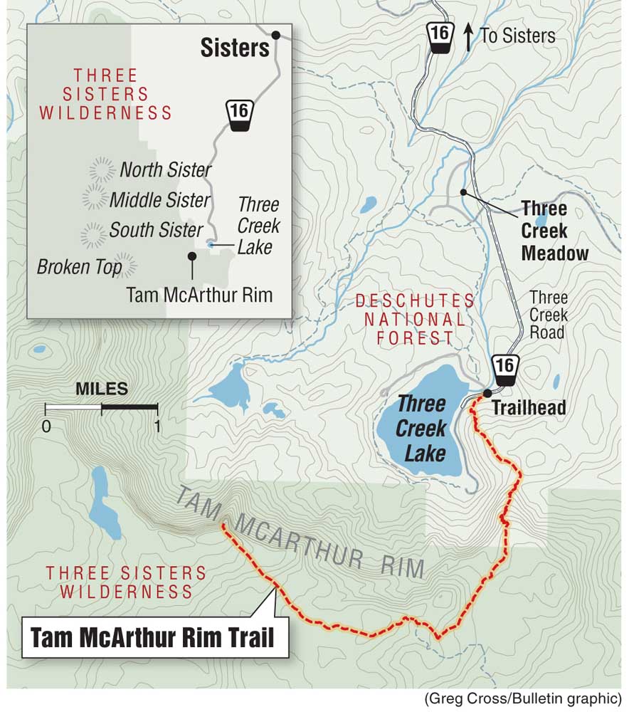
The 5.3-mile round-trip hike to the rim from the trailhead at Three Creek Lake includes 1,400 feet of elevation gain — the high viewpoint sits at 7,730 feet — and typically takes no more than three hours. And it includes the payoff of incredible Cascade views at the top.
The ride from Bend to the trailhead requires about an hour. The road in to Three Creek Lake is gravel, dirt and a little bumpy, but the hike is well worth the drive.
I arrived at the trailhead early last Sunday morning, hoping to complete the hike before the sweltering heat of the afternoon.
The parking lot at Driftwood Campground was nearly full. Though a bit of a drive from Bend, Tam McArthur Rim is a popular area this time of year, but most of the folks in the area were paddlers, swimmers or anglers enjoying the beauty of the small alpine lake.
I ended up having the trail to myself during most of the ascent to the rim.
Usually, snow prevents hiking access until late spring, as Tam McArthur Rim is also a popular backcountry ski destination during the winter. Its steep north-facing slopes offer perfect lines for skiing and snowboarding.
The trail started just across the road from Three Creek Lake and led me up dusty switchbacks to the opposite side of the rim. Views of the lake and North and Middle Sister popped up to the west as I climbed.
Eventually, the trail flattened as I reached the crest of the rim along an open plateau. The section was hot and treeless, and luckily I had lathered the sunscreen on before starting the hike.
During the last precipitous push to the viewpoint, craggy, jagged Broken Top dominated the horizon to the west. The trail cut along the edge of the rim, and I could see both Three Creek Lake and neighboring Little Three Creek Lake far below.
The summit of the rim offers a nice, flat area from which to view numerous Cascade peaks and eat a sack lunch. Mount Washington, Three Fingered Jack, Mount Jefferson and Mount Hood were all visible to the north on the clear, smoke-free day. Both North and Middle Sister jutted skyward to the west.
According to the Oregon Historical Society, the rim is named for Lewis A. McArthur, known as “Tam” McArthur, who was an executive for Pacific Power & Light Company and was also secretary for the Oregon Geographic Board for many years. In 1928, McArthur published his book “Oregon Geographic Names,” which, now in its seventh edition, is a comprehensive source on the origins of Oregon place names.
The trail officially ends at the viewpoint, but an unmaintained trail continues west along the rim and eventually connects to other trails near Broken Top.
I continued along the trail, hiking an additional mile and a half to the top of a ridge where I could see even more spectacular views of the Central Oregon Cascades.
Finally I turned around and made my way back to the trail along the rim, and down toward Three Creek Lake. Several flat sections along the trail near the rim make for decent trail-running terrain, and I jogged about 2 miles before the trail steepened in its descent.
I ended up hiking/running 8.4 miles in about three hours, including significant time at the viewpoint atop the rim.
The trail overall was steep and sandy in some sections but relatively easy and nontechnical — ideal for hikers looking for a moderate trek with gorgeous Cascade views, and a lake in which to swim afterward.
— Reporter: 541-383-0318,
mmorical@bendbulletin.com


Best of the Best of Bend 2025

-
eEdition

-

-
Go! eEdition