Mountain Bike Trail Guide: Horse Ridge
Published 7:16 am Thursday, September 27, 2018
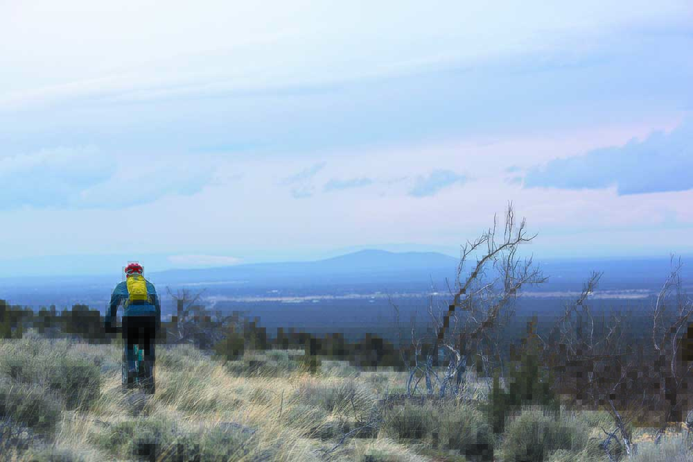
- Horse Ridge offers mountain bikers challenging rides with sweeping views of the High Desert.
The wind whipped across the High Desert as I continued climbing up the steep trail along sagebrush and gnarled juniper trees.
Wide-open vistas, Cascade mountain views, long climbs and thrilling descents can all be found on the nearly 30 miles of singletrack on Horse Ridge.
Located about 15 miles southeast of Bend in a seemingly desolate area where the terrain offers a stark contrast to the trails west of Bend, Horse Ridge is a favorite of local mountain bikers in the fall and winter. Sometimes the trails remain ridable year-round — though not last winter, when Central Oregon was covered in significant snow for weeks.
Perhaps this winter will be milder, but now is an ideal time to head to Horse Ridge before the snow returns.
I made the short drive there last week on a sunny-but-windy day, looking to ride prime singletrack after recent rainfall.
From the trailhead — which features a paved parking area and a kiosk with a map of the trails — bikers have two main options for singletrack. They can go left and ride a rolling trail along a fence line close to U.S. Highway 20, or go right and begin a tough ascent through a shallow canyon. Both options can lead to 10- to 15-mile loops or longer. And both trails climb to a ridgeline that includes dramatic panoramas of the seemingly endless desert landscape east of Bend.
Horse Ridge tops out at an elevation of about 4,700 feet, so lots of climbing and downhill are available.
I started out with the challenging climb through the canyon, which included a few rocky, twisting switchbacks through a juniper forest. Some of the oldest known Western juniper trees are found on the slopes of Horse Ridge, according to the Bureau of Land Management. As I rode, I observed the Badlands Wilderness stretching to the north.
On that clear day I could see the snow-covered Three Sisters, Mount Jefferson, Mount Washington, Three Fingered Jack, and even Mount Hood to the distant north. Directly across Highway 20 from Horse Ridge is Dry River Canyon, which makes for a nice fall hike for those mountain bikers who still have energy after a ride on Horse Ridge.
The trail became increasingly technical, with jagged lava rocks rising up out of the desert at sharp angles.
I finally came to a spot where the ridge seemed to drop 1,000 feet straight down. I rode back to a junction I had spotted earlier, then turned onto a downhill singletrack trail straight through a gully. The twisting and rolling trail, mostly downhill with some short climbs interspersed, eventually led me back to the trailhead to complete the approximately 15-mile ride.
Here are some other fall/winter options for Central Oregon mountain bikers:
Smith Rock State Park
Many options are available for mountain bikers at Smith Rock State Park, from a relatively flat and easy ride along the park’s River Trail to a grueling climb up Burma Road.
That climb leads bikers to some thrilling singletrack that cuts between Smith Rock and Gray Butte to the northeast. The trail offers endless views of the Crooked River National Grassland and the Cascade Range.
From the top of Burma Road, mountain bikers can connect to the Gray Butte Trail leading toward the butte. They can then complete the Cole Loop to the east or the Burma Loop to the north. Both rides skirt the summit of Gray Butte.
From the Gray Butte Trail, bikers can connect to the Summit Trail and then the River Trail to loop back around Smith Rock State Park.
Horse Butte
Located just a few miles southeast of Bend, Horse Butte is a popular locale for fall and winter mountain biking. The singletrack in the Horse Butte area is relatively flat and nontechnical, making it approachable for all skill levels.
Mount Bachelor, the Three Sisters, Broken Top, Mount Washington and Mount Jefferson can all be seen to the west on a clear day on the Horse Butte trails.
The Coyote Loop Trail and Arnold Ice Cave Trail (Trail 63) form a loop of about 10 miles that makes for a good ride in either direction. But riders should be wary of muddy conditions in the area. When the ground freezes overnight then thaws the next day, the trails can become a mess — and riding in mud leaves behind ruts that damage the trail.
Maston
Scattered juniper trees and the dramatic Deschutes River Canyon highlight the Maston area, located between the town of Tumalo and Eagle Crest Resort west of Redmond.
The Maston area offers a network of mostly flat trails in an area that typically stays relatively dry and snow-free during the winter — not counting last winter, though, when deep snow covered even the lower-elevation areas around Redmond.
The Bureau of Land Management has designated Maston as a mountain biking area in the Cline Buttes Recreation Area Plan. Maston includes about 4,000 acres of the plan’s 32,000 acres (50 square miles), where trails are being built for mountain bikers, hikers and horseback riders.
The main BLM Maston Trailhead on the south end of the network includes a large parking area, restrooms and kiosks with maps. The trailhead is a starting point for mountain bikers to explore about 20 miles of singletrack with various loop options. Some trails include rocky challenges, including one trail that skirts the scenic river canyon. But the Maston trails are mostly nontechnical and ridable even for beginners.
To the west from Maston, bikers can glimpse at views of the snowcapped Cascades, including Broken Top and the Three Sisters.
Before the snow blankets the High Desert, mountain bikers have a multitude of options in Central Oregon.
— Reporter: 541-383-0318,
mmorical@bendbulletin.com
Horse Ridge
Directions: From Bend, head east on U.S. Highway 20. About 15 miles from 27th Street, turn right at a stop sign onto the Horse Ridge frontage road. The turn is immediately before the highway begins climbing a long hill, and an Oregon Badlands Wilderness sign is located on the left. Once on the frontage road, proceed 0.7 miles west. Look for the BLM trailhead on the left side of the road. There are two singletrack choices from the parking area.
Length: Loop option of varying distances, with a total of about 30 miles of trail.
Rating: Technically advanced, aerobically intermediate.
Trail features: Plenty of singletrack with expansive views of the High Desert. Lava rocks make for lots of technical challenges. Trails are currently in ideal shape, but avoid riding them in the summer when they are extremely sandy.
Season: Fall, winter, spring
More rides can be found at bendbulletin.com/rideguide.


Best of the Best of Bend 2025

-

-
-