Mountain Bike Trail Guide: Tyler’s Traverse and Duodenum
Published 7:16 am Thursday, September 27, 2018
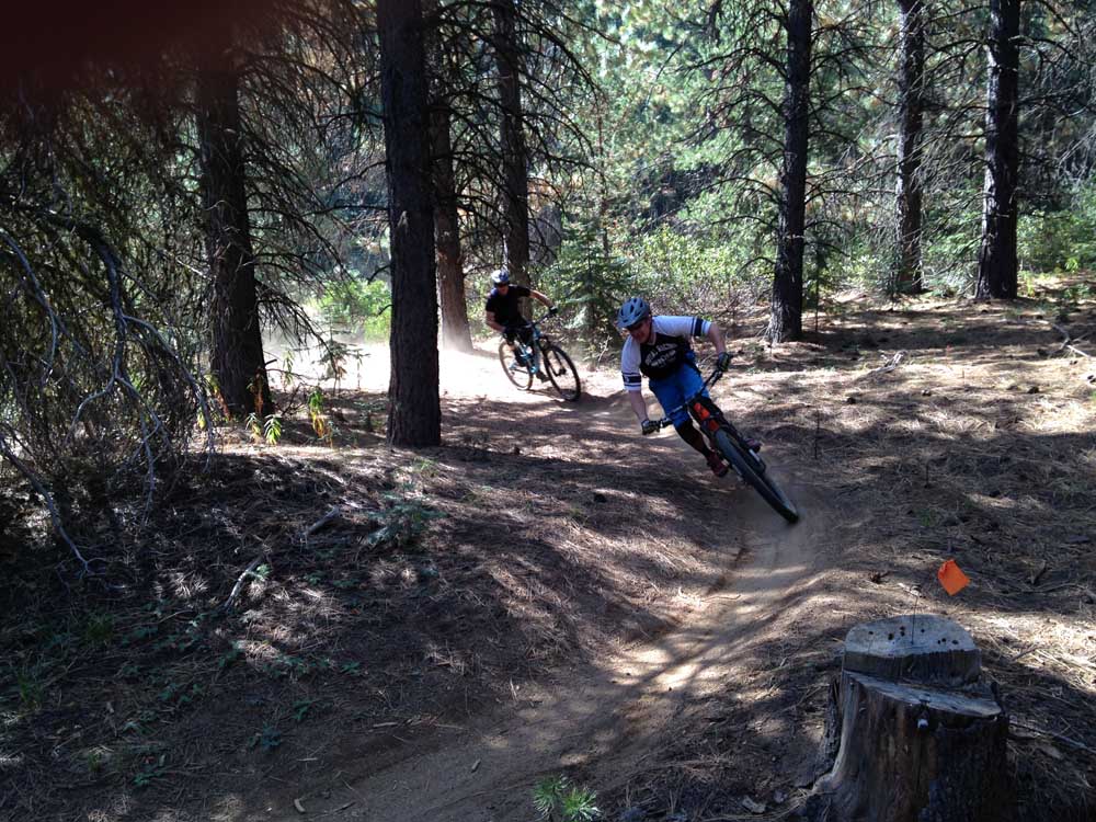
- Mountain bikers descend the Tyler’s Traverse Trail southwest of Bend.
The poor air quality that pervaded Central Oregon over the past few weeks had kept me off my bike for far too long.
But this past weekend, with fresh blue skies over Bend, I knew I had to get back out there before the smoke from numerous wildfires blew back into the region and made the air unhealthy once again.
What better way to find my mountain-biking mojo again than by trying out a new trail?
Even after riding in Central Oregon for the past 16 years, it seems I can always discover another trail in our vast network of premium singletrack. The Central Oregon Trail Alliance (COTA) is often hard at work building and designing new trails, especially in the Wanoga complex southwest of Bend.
The area off Conklin Road near Century Drive has a couple of different trailheads that give mountain bikers several loop options. One such trailhead is Tyler’s Traverse, which now includes a one-way uphill route to complement the one-way downhill trail.
Duodenum is a relatively new 4-mile-long lollipop offshoot of Tyler’s Traverse that I wanted to try while the air was clear.
I started from the Tyler’s trailhead and began making my way along the uphill route. This is a tough climb that requires a bit of stamina in the steeper sections. It’s not a route a biker would want to take in unhealthy air conditions.
Eventually the singletrack turned to doubletrack, and I continued along the challenging climb toward the intersection of lower Tyler’s Traverse and Duodenum. (Mountain bikers also can start from the Storm King Trail off of Conklin for a different loop option, or shuttle a route by parking a vehicle at Conklin Road near the west end of the trail and then driving another vehicle to Wanoga Sno-park.)
But climbing the uphill path is a mountain biker’s way of “earning the turns.”
The forest became deeper and darker as the trail got steeper, and finally, after a few miles and about 45 minutes in the saddle, I reached the Duodenum junction.
The lollipop loop can be ridden in either direction, so I tried both, and discovered that clockwise was the best. The trail includes about 20 sharply banked corners that test slalom skills and also brakes when ridden downhill. The switchback path is carved into a heavily forested hillside in a fairly remote section of the Deschutes National Forest.
I saw no other bikers on Duodenum but several on the more popular Tyler’s Traverse.
After cruising through the thrilling, banked turns along Duodenum, I eventually arrived back at the intersection with lower Tyler’s.
At the junction, some signs read “Do not enter,” while others read “One way.” COTA has done a remarkable job of implementing its new directional trail system with signs that are clear and unmistakable. While most singletrack mountain bike trails in Central Oregon remain open to two-way travel, a select few were designated as uphill or downhill only in recent years.
Tyler’s Traverse includes both uphill and downhill routes. I turned onto the downhill path and soon arrived at a section of trail that took me over an array of bumps and rises and around some small banked corners.
The sustained downhill seemed to last forever as I caught a bit of air over several jumps and cruised through the forest. While lower Tyler’s Traverse can be classified as more of a free-ride trail, its features are modest enough that intermediate riders — and riders who prefer strictly cross-country trails — should feel comfortable on it. The trail is not as intimidating as, say, the Whoops trail in the Phil’s Trail network just to the north. But it is fast and does requires some technical free-riding skills.
By the time I arrived back at the trailhead, I had ridden about 12 miles in about 2½ hours — a perfect Sunday morning ride in clear, fresh air.
Luckily, the air quality has remained good to moderate over the past few days in Bend, making for fine riding conditions, which should only improve as fall approaches.
— Reporter: 541-383-0318,
mmorical@bendbulletin.com
The trail includes about 20 sharply banked corners that test slalom skills and also brakes when ridden downhill.
Tyler’s Traverse and Duodenum
Directions: From Bend, drive southwest on Century Drive to Conklin Road. Turn left and drive about 4 miles to a gravel parking area on the right. The Tyler’s Traverse uphill route begins from the parking area. The downhill route ends at the parking area. Bikers can ride the uphill route to access the Duodenum loop trail.
Features: A challenging climb and a mix of swooping downhill with moderate technical trail features, including jumps and banked turns.
Distance: Varies depending on loops; ride featured here is about 12 miles.
Rating: Aerobically moderate to strenuous and technically intermediate to advanced.
Season: Late spring through fall.
More rides can be found at bendbulletin.com/rideguide.
Editor’s note: Mountain Bike Trail Guide, by Bulletin outdoors writer Mark Morical, features various trails in Central Oregon and beyond. The trail guide appears in Sports on alternating Thursdays through the riding season.


Best of the Best of Bend 2025

-
eEdition

-

-