History, tranquility await in Summer Lake Basin
Published 12:00 am Sunday, January 27, 2019
- History, tranquility await in Summer Lake Basin
“At our feet — more than a thousand feet below — we looked into a green prairie country, in which a beautiful lake some (20) miles in length was spread along the foot of the mountains … just then the sun broke out among the clouds, and illuminated the country below, while around us the storm raged fiercely. Not a particle of ice was to be seen on the lake, or snow on its borders, and all was like summer or spring.”
The words from John Fremont’s journal echo through the Summer Lake Basin, reverberating off the ridges and through the valleys he explored during his second expedition with the Corps of Topographical Engineers in 1843. His journal (which can be read in its entirety online, thanks to Google Books) is packed with awe and wonder of the lands few Europeans had seen.
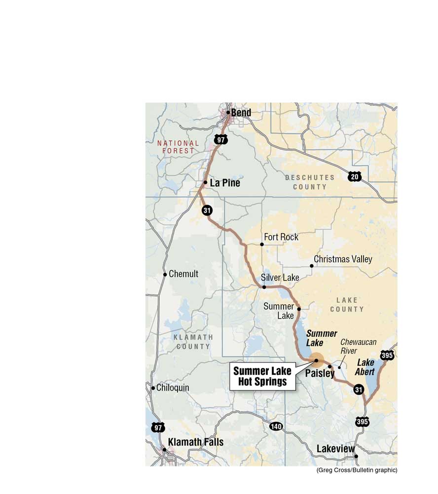
The Summer Lake area is dotted with small towns, farms and ranches, but this destination 100 miles south east of Bend still invigorates the senses.
During the expedition, Fremont and his party trudged through “snow about 3-feet deep, which being crusted, very much cut the feet of our animals,” and as each one reached the ridge to take in the valley below, they let out whoops and hollers at the sight of the snowless lake beyond them.
The juxtaposition of the weather patterns observed during the expedition gave Summer Lake and Winter Ridge (also called Winter Rim) their names.
These days, accessing the lake is easier than what Fremont described. Highway 31 cuts into the Basin through Picture Rock Pass north of the ridge. Travelers can find petroglyphs in the rocks just off the road. The images were made by the Native Americans who inhabited the area.
As travelers rise out of the pass, Summer Lake glimmers on the horizon. Depending on the time of year, the lake water fluctuates from nearly dried up to about 15-miles long and 5-miles wide with a depth of 5 to 7 feet.
North of the lake is the town of Summer Lake; the unincorporated community has a population of 110 people.
It’s a lush, green relief from the sandy and alkaline colors of the lake and the basin surrounding it. The Summer Lake State Wildlife Area preserve is located in the small town.
It has been overseen by the Oregon Department of Fish and Wildlife since 1944 and is largely for migratory and resident birds including pelicans, herons, egrets and bald eagles.
Soaking in the landscape
Although Fremont described the lake as being “like summer or spring,” the winter winds can howl through the basin, biting at a visitor’s face and ears.
One way winter visitors can warm up is by soaking at the Summer Lake Hot Springs resort, which is to the south of the lake.
The resort is built around the natural springs and hosts the pool that has been welcoming sore bones and cold toes since the earliest people stumbled across its soothing waters.
The larger and oldest pool is housed in a bathhouse (think modified barn) that has stood over it since the 1920s. It’s somewhat-rusted, corrugated metal siding is weathered from time and the powerful winds that can whip through the basin.
The hot water is pumped directly from the source and pours into the 15-by-30 foot pool via a PVC pipe protrudes from the wall. The water temperature measures between 108 and 116 degrees, but air temperatures can make the pools feel slightly cooler. Unfortunately, the large pool is currently closed for repairs until the third week of February.
On either side of the hot spring pool are dressing stalls. There are showers for guests to rinse off dirt, grease, lotions or perfumes before they take a dip.
The water is untreated and completely natural with a high content of sodium, sulfate, potassium, chloride and silica. The higher silica content is what gives it a silky feel on a person’s skin as they float around.
The wooden bathhouse walls are etched with graffiti from visitors past. Though the practice is not allowed, that hasn’t stopped people from carving their names, dates, logos and memories.
The top of the bathhouse is open. Chicken wire spread across the openings helps keep most the critters out.
A more recent addition to the resort are three rock and concrete lined pools outside the bathhouse walls. Each holds about six adults. Wind tolerance is a must to experience sitting in the outdoor hot springs.
Enjoying a hot springs soak outdoors means an opportunity to enjoy the magnificent landscape or watch storms form over Winter Ridge or nighttime stargazing. With few local residents and almost no light pollution, the night sky can be spectacular.
A day pass to the hot springs, which are open from 9 a.m. to 7 p.m. daily, is $10. The resort has several cabins (and continues to build more), full RV hook-ups and tent camping sites available.
For overnight guests, the pools are open 24 hours with children allowed until 9 p.m. After that, clothing is optional. The resort is open year-round.
Small town charms
On Dec. 19, 1843, after Fremont traveled south from Summer Lake along the ridge, he came upon a marshy area where a “rapid stream (roared) along between banks overhung with aspens and willows.”
Once home to seasonal camps of the Northern Paiute and Klamath tribes, the area about 10 miles from the southern shore of the lake was homesteaded during the 1870s.
The farms and ranches diverted waters from the Chewaucan River for irrigation and altering the marsh into workable pasture land.
Crossing over the Chewaucan, the town of Paisley appears suddenly out of the scrublands, 6 miles south of the hot springs. With a population of 270, it has no stop lights and Highway 31 cuts right through it. Named after the town in Scotland, Paisley was incorporated in 1911.
Food options are few and far between out there, The Lodge at Summer Lake hosts The Flyway Restaurant and Paisley has the Pioneer Saloon and Restaurant. The Homestead Cafe has recently closed due to a fire in November 2018.
The Saloon, which opened in 1883, is one of the oldest drinking holes in Oregon. The actual bar, which is still there to be bellied up to, made its way from Boston in 1906. The saloon’s walls are adorned with lariats, Western art and old bumper stickers with local appeal.
The menu is typical of most pubs: burgers, sandwiches, a few salads and pizzas. The pizzas are made fresh.
Those seeking a tangible memento from their trip can pick up some swag before heading back to their adventures: black T-shirts, tank-tops and hats with an Antelope bust are available for purchase.
Next door is the mercantile for those quick coffee or soda purchases, to pick up fishing or camping gear, groceries and even more Paisley souvenirs. Running through town is the Chewaucan River, home to redband trout and multiple hiking trails up stream. Down here, the river begins to meander towards it eventual end 20 miles southeast.
Hey Abert!
Nestled between two long ridges is home to one of Oregon’s largest lakes, or it was, Lake Abert. The lake is located about 25 miles south of Paisley and right before the town of Valley Falls.
In recent years, Lake Abert has been drastically shrinking. Fed entirely by the Chewaucan River with no outlet, Lake Abert has been receiving far less water than is typical due in part to climate change and nearby farms and ranches needing to water crops. The last time it was at these levels was during the Dust Bowl in the 1930s.
Lake Abert was named after J.J. Abert, the Chief of the Topographical Engineers expedition in 1843. The lake is shadowed by an imposing ridge, the Abert Rim, on its east shore.
“Throughout this region the face of the country is characterized by these precipices of black volcanic rock, generally enclosing valleys of streams, and frequently terminating the hills,” Fremont wrote.
This is the main characteristic of the Basin and Range province that stretches across much of the American southwest and reaches into northern Mexico.
Lake Abert is alkaline, making it uninhabitable except for insects and tiny brine shrimp. These minuscule crustaceans encourage migrating birds to stop by for a feast in the lake’s salty waters. At least they did.
There are no boat launches on the lake and prolonged exposure to the water can be hazardous to the skin. Pull outs on the road around it provide information on the birds, the brine shrimp, the history of the area — including Glacial Lake Chewaucan — and makeshift trails down to the water.
The ridge that shadows the remains of the lake looms 2,500 feet above its surface. Towering skyward, it is one of the largest exposed fault scarps in North America and one of the highest in the U.S., according to the Bureau of Land Management.
The stunning cliff face is the southern boundary of the prehistoric pluvial lake. At one point, it covered 460-square miles and reached a depth of 300 feet.
As the waters subsided, wave cut caves were created. Native Americans used the caves during their seasonal migrations. In fact, the earliest known evidence of humans in North America were discovered in Paisley Cave (to the west of Paisley), which indicate activity as far back as 14,500 years ago. Summer Lake and Lake Abert are the only remnants of the vast Glacial Lake Chewaucan.
The view alone is breathtaking. With Abert Rim’s striking dark basalt cliff towering above the road along the lake, the dichotomy of textures, colors and shadows are spectacular.
Following Fremont
It took Fremont and the Corps of Engineers four days to travel from their lookout on Winter Ridge to the shores of Lake Abert. Now it would take roughly an hour to make the trek.
On Christmas Eve in 1843, Fremont remarked that “The country has a very forbidding appearance, presenting to the eye nothing but sage and barren ridges.” But there is something special to the barrenness that may envelope the country.
Even the alkaline and salt lakes that are drying up, present an invigorating sense of the landscape, and still hold on to some semblance of life in the birds that flock to the area.
From its ancient history to the modern people who reap the benefits of the land, Summer Lake Basin gives beauty and tranquility to the journey ahead.
—Makenzie Whittle is a Bend native. She and her family have taken day trips since she was an infant, exploring the far reaching corners of Oregon, learning about history, geology and the communities that make up the state. She continues the tradition today, and can be reached at 541-383-0304 or mwhittle@bendbulletin.com


Best of the Best of Bend 2025

-
eEdition

-

-
Go! eEdition