Skiers and boarders keep a close eye on the forecast to find prime conditions
Published 12:00 am Thursday, February 14, 2019
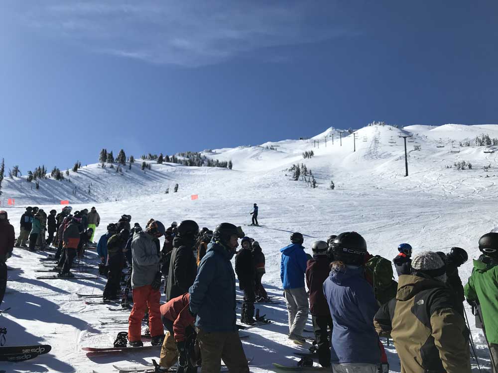
- Skiers and snowboarders line up to wait for the Summit chairlift to open at Mt. Bachelor ski area in 2019.
MOUNT BACHELOR —
The line for the Summit chairlift on Wednesday of last week stretched all the way back to the top of the Sunrise lift. I arrived just in time to find a good enough spot in the line that I could still expect to get fresh tracks from the mountaintop.
As ski patrol readied the slopes, skiers and snowboarders waited patiently for the chance at about a foot of fresh powder and 3,000 feet of vertical. When the lift attendants cleared the ropes, cheers echoed across the slopes and snowriders made their way through the gates and onto the Summit lift.
Many of them had undoubtedly been tracking the recent storm activity and saw this day as a break in the storm and a chance for a bluebird day of virgin-snow Summit runs.
“We had been looking at that day for four or five days on the forecast,” said Tom Lomax, director of mountain operations at Mt. Bachelor ski area. “It looked like that was probably going to be the clearing (skies) day for Summit.”
Most skiers and snowboarders these days — especially locals — watch forecasts closely in order to time their trips to Bachelor and other ski resorts, looking to take advantage of the best possible conditions. Most of them are in search of one thing: powder.
While sunny days are nice and sometimes rare in the depths of a Central Oregon winter, powder days are what drive skiers to the slopes.
“A hundred percent powder,” Lomax said. “They don’t care anymore about sunny, dry groomer days. Our skiers and riders are a hundred percent driven by new snow now.”
New snow off the Summit lift draws a crowd. Typically, the lift will remain closed in periods of high winds and low visibility during a storm cycle. But when the weather clears and Summit opens, skiers and boarders are treated to all the new snow that has fallen during that storm.
As soon as they see chairs start running on the lift, snowriders will flock to line up at Summit.
“We’re always pushing to get it open,” Lomax said. “There’s a lot of factors involved. Anymore, there’s enough people willing to wait it out that if you want to get up there for first tracks you’ve got to get into the line. That’s just kind of the eagerness for people to get up in fresh snow.”
I was situated in about the middle of the line last week, so by the time I made it to the top, there were plenty of fresh tracks available off Cow’s Face, Bachelor’s eastern slope. I then skied two runs in the Cirque Bowl — the large bowl just below the summit — turning deep through light, velvety snow. There, snow gets blown into deep pockets below the rocks and boulders that frame the top of the peak.
Locals beeline to Bachelor anytime there is fresh snow, and those opportunities have been frequent of late. The mountain has received 2 feet of new snow in the last three days and more than 3 feet in the last week. The snowpack at Bachelor is now at 90 inches, as the mountain and its skiers and riders are enjoying a winter that was expected to be warmer and drier than usual based on the El Niño forecast. Recent cold temperatures have also kept the new snow dry and light, the type of conditions storm-tracking skiers crave.
“It’s been really good if you look at the numbers,” Lomax said. “And the quality of the snow has really been quite good. We’ve really only had one rain event.”
For skiers and snowboarders who pay close attention to the forecast, the National Weather Service is usually a reliable place to start. Lomax recommends the University of Washington’s MM5 forecast, which offers more detailed forecasts for those snowriders who really want to delve into meteorology and climatology.
“It’s pretty overwhelming,” Lomax said of the MM5. “But I look at that every day. You want to look at the trend. I look at the seven-day pattern on the MM5, and I get a quick overview of what’s going on for the next seven days.”
While snowriders can look at the forecast to pick and choose their ski days, Lomax and other ski patrollers watch it to get an idea of how the weather will affect lift operations. They keep an eye on breaks in a storm to see when they might be able to get the Summit lift open, and they watch for a warming trend that can cause freezing rain and heavy, thick rime ice that can delay lift operations.
Looking at forecasts to be prepared is always smart, but weather can be fickle and forecasts constantly change. Lomax said that any forecasts between seven and 14 days out are mere climatology and general trends.
“At seven days out, that can give me an early warning of stuff coming up: looks like a cold trend, looks like there’s a ton of moisture coming in or whatever,” Lomax explained. “Down to the four-day range is getting to where the pattern will probably happen. Then it comes down to the microclimate, too, where, Bachelor has a distinct microclimate and we get a lot of weather that’s not really forecast.”
One element of the weather that changes often at Bachelor is the wind. Lomax said he follows the east-wind weather models. If east winds are predicted to be about 15 to 20 mph in the Columbia River Gorge, he said, that could make for winds of 60 to 70 mph at Bachelor.
“That’s because of the geographic location we’re at and the way that the pressure gradient works across the state,” Lomax said.
Skiers and riders can chase storms to find prime snow conditions, but they would be wise to know it is never a sure thing.
“So when you do score and get a big payoff and get a really nice powder day with great visibility,” Lomax said, “it’s still kind of rare.”
—Reporter: 541-383-0318,
mmorical@bendbulletin.com
More Outdoors


Best of the Best of Bend 2025

-
-
-