Falling for Silver Falls State Park
Published 12:00 am Sunday, March 24, 2019
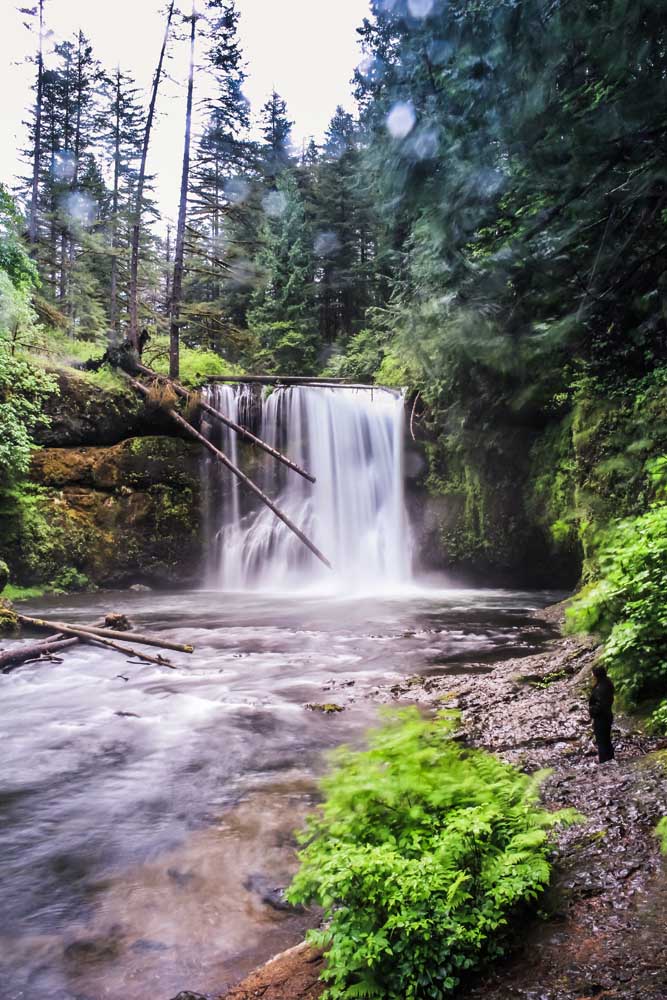
- Upper North Falls in May 2013. The 65-foot waterfall empties into the North Fork of Silver Creek. (Makenzie Whittle/The Bulletin)
Oregon’s largest state park emerged thanks in part to the timber industry, a stock market crash, Franklin D. Roosevelt, a persistent photographer and thousands of years of geologic wear and tear on the landscape. Silver Falls State Park, a 9,200-acre park surrounded by farms and foothills of the Cascades, features more than a dozen waterfalls, an elaborate trail system and campgrounds, drawing over a million visitors every year from around the world.
Before the emails and Facebook messages come rolling in, it hasn’t been called Silver Creek Falls State Park since the 1940s, though many locals still stick with the old name.
Name confusion aside, one thing everyone can agree on is the captivating beauty the park holds.
Area day-trippers are joined by the global travelers to traverse the park’s 24 miles of walking trails, 14 miles of horse trails and a 4-mile bike path as they explore the scenery, wildlife and history of this transcendent park.
A map in the Silver Falls Nature Store visualizes the number of visitors with pins on a world map. In early March, cities in northern England, Brazil, eastern Africa, Australia and beyond were punctured with small tacks, examples of who will visit throughout the year.
These global visitors and locals alike come for one main reason: the waterfalls.
Ten(ish) falls
Visitors going to Silver Falls during late winter will feel the crisp air and the morning mist that seem to inundate the Willamette Valley. This year there is an unusual sight on the west side of the Cascades: snow. The snow leaves behind a slushy and slick terrain that squishes and slides with each step.
The Trail of Ten Falls gives visitors the best access to all of the waterfalls within the park. It is a 7.2-mile moderate hike that descends far into the canyon, running along both the north and south forks of Silver Creek, looping back up to the ridge, parking areas and trailheads.
While the trail’s name is an indication of how many falls visitors can see, it depends on the season and overall water levels as to how many are gushing and how many are merely a trickle.
The most popular (and easily the most photographed) waterfall of the park is South Falls. A short walk down from the South Falls Historic District and main parking area, the trail is only tricky when the weather has provided muddy or slushy conditions, which is common in this soggy terrain.
The south fork of Silver Creek plummets 177 feet over a precipice, giving way to the splendid, cascading waterfall. The walls of the canyon surrounding the park’s second-tallest water feature are lush and green in the height of spring and summer. That vibrant emerald color is traded for a harsher black basalt in the winter.
The trail meanders downward, leading behind the waterfall. The powerful force of the water sprays hikers’ faces with mist, prompting wide grins. That same force is what carved a small cavern in the canyon wall, allowing the trail to be built directly behind the falls, one of four falls on the trail to allow this.
The walk continues to descend into the canyon carved by the creek, muddy but only occasionally steep, with a side trail to the small — and only seen during the incredibly rainy season — Frenchie Falls.
About a mile down the trail, there are several flights of concrete descending steps. Navigating these may require some finesse as the steps become slippery with water, snow and mud. There is a metal railing to help steady visitors if needed.
The difficulty is worth it. Midway down the stairs the view expands, exposing the full canyon, the Lower South Falls and the lush foliage.
Though shorter than its upstream neighbor at 93 feet, it is wider, making the path behind it even more invigorating and deafening from the echo of the rushing water pounding the ancient basalt rock.
Beyond that, it’s another mile before the next batch of waterfalls makes its appearance. Nevertheless, there is still plenty to marvel at.
Nestled among towering Douglas fir and with bright green ferns creeping over ridges, the trail largely follows both the south and north forks of Silver Creek.
Snags and fallen, decaying trees offer an abundance of moss, lichen and mushrooms, as well as a habitat for all kinds of critters.
Taking a moment to stop and listen to the sounds of the forest can reveal the cries of red-tailed hawk, the sight of a varied thrush as it hops along the forest floor and, if lucky, one of the park’s resident owls.
Seasonal falls can spring from the canyon walls during the winter and early spring months. These are usually nameless and smaller, but are still worth a look.
Eventually, the trail crosses the north fork of Silver Creek, and hikers are met with the quiet roar of another waterfall.
Once you turn the corner, the source of the sound reveals itself: the short, cascading Lower North Falls.
Unlike the previous two plunge falls, this one hugs the rocks as it plummets, like a water-based ride at a theme park.
Within the next half mile, there are three more falls.
A short, narrower spur trail leads to Double Falls. At 178 feet, this is the park’s tallest waterfall, beating South Falls by a foot. Its name comes from the split-drop style of the falls. One “upper” falls plateaus briefly before plunging down again, this time for a longer drop.
The ribbonlike lower waterfall hits a shallow, rocky pool with a great force. The small valley it falls in creates a strong wind that whips across the trail, mixing with the spray from the water — an icy combination.
Back on the main trail and up a small hill is Drake Falls. Named for one of the first and most persistent supporters of the park, photographer June Drake, whose photographs and dedication to the park helped with its establishment under the State Park banner.
These falls also cling to the rock face while plummeting down into a calmer, icy blue pool below.
Dappled with sunlight from the evergreen canopy above, the trail continues along the north fork where a downed tree on the trail forces hikers to maneuver under or around it.
Soon, the 106-foot Middle North Falls appears ahead. A short side path offers a chance to walk behind the falls. This section of trail, while fairly wide, has no railing between it and the edge.
The trail continues uphill where a fork in the road can either lead you back to the Rim Trail via the Winter Trail, or continue to Twin, North and Upper North falls.
Or do both.
Winter Trail is a half-mile leading to Winter Falls. Aptly named, as those are the only falls fully in view during the winter. Come the end of summer, the stream trickles down the rocks and the surging falls are mostly a memory.
This narrow fall can be best seen by the edge of the trail, where a bench welcomes weary travelers to take a moment and enjoy the view.
Returning to the larger Canyon Trail brings Twin Falls. The 30-foot waterfall is split at the top by a large rock in the creek, causing two distinct channels. The water gushes through these channels, creating an abundance of whitewater.
A little over a mile further is North Falls, another plunge-type fall, this one measuring 136 feet and the fourth and last fall to walk behind with the largest cavern. This particular 300-foot-wide amphitheater also features a cast of a tree that was engulfed in the hot molten rock that swept through the area, then cooled.
The last of these 10 falls with an equally ordinary name, is equally as beautiful. Upper North Falls is a classic-looking rectangular waterfall with the trail close enough to the creek that the area can get very, very wet during the rainy season.
Doubling back to the Rim Trail over a quaint wooden bridge, hikers are this time thrust into the heart of the treed terrain here. The wider dirt path crosses the many parking areas and access points to the Trail of Ten Falls and ultimately ends up at the picturesque South Falls Historic District.
New Deal, new park
Homesteaders to the Silver Falls area began arriving in 1883 and quickly took to farming and logging the area. In 1929, the lumber industry tumbled when the stock market crashed.
The land was already decimated by logging, and much of the areas surrounding the current park were clear cut. The timber here was used to literally build much of the state. But without buyers, no more trees could be cut.
Enter President Franklin D. Roosevelt and the New Deal.
One piece of the program he implemented was the Civilian Conservation Corps, a lifeline for many young men and their families during the Great Depression.
These work crews came to Silver Falls like they did to so many rustic locations across the country. Constructing buildings, bridges, trails and more, they worked five days every week for 40 hours. They were paid $30 per month and had to send $22 to $25 of that paycheck home. For reference, that $30 today would be approximately $540. The workers constructed buildings and trails that remain today.
The park, called Silver Creek Falls, was dedicated on July 26, 1933, in part because of the efforts of June Drake and Samuel H. Boardman, the first superintendent of Oregon state parks. The Civilian Conservation Corps stayed on to work in the park and help maintain it.
The park was small; consisting of 700 acres, it was primarily a day-use area containing the canyon and waterfalls. But on the other side of state Highway 214 was a much larger park also created as a part of the New Deal.
The Silver Creek Recreation Demonstration Area was formed by purchasing land from the farmers who could no longer feasibly manage it and reclaiming it for forest restoration and recreation. The farmers were then resettled to more productive areas.
The Silver Creek RDA was one of only two on the West Coast (the other was in California’s Mendocino Woodlands).
Originally managed by the National Park Service, in 1948 the RDA was deeded to the state and merged with the state park.
Dropping the “Creek” from the name and adding another 6,000 acres of land, the park would continue to grow, adding camping, dozens of miles of trails and youth camps set up in the old Civilian Conservation Corps camp buildings.
The park would also be home to one of the earliest forest restoration projects in the state.
The structures built by the Civilian Conservation Corps largely still remain and have been placed on the National Register of Historic Places and contain the park’s modern amenities like the Silver Falls Nature Store, theater and South Falls Cafe in the old lodge.
The buildings made of stone and wood maintain their rustic patina, transporting visitors to a bygone era when they step inside.
Staying Silver
The million plus visitors that frequent Silver Falls largely visit during the summer, taking advantage of camping, swimming holes and miles of walking trails beyond the Ten Falls hike. Visitors bring their horses, bikes and comfortable shoes, and sometimes join in park-organized programs like an Owl Prowl.
The winter and shoulder seasons offer spectacular views as well as vibrant colors of green in the spring and gold in the autumn.
Despite the abundance of people, the trails and facilities are impeccably maintained by the parks department and with the help of the nonprofit Friends of Silver Falls, which helps with improvements and educational programs.
From its earliest days and first promoters in June Drake and his photographs to the millions of worldly hikers strolling through the Douglas firs and moss-peppered paths, Silver Falls remains a star of Oregon State Parks.
—Makenzie Whittle is a Bend native. She and her family have taken day trips since she was an infant, exploring the far reaching corners of Oregon, learning about history, geology and the communities that make up the state. She continues the tradition today, and can be reached at 541-383-0304 or mwhittle@bendbulletin.com


Best of the Best of Bend 2025

-
eEdition

-

-
Go! eEdition