John Day Fossil Beds offer a journey through time
Published 12:00 am Sunday, April 28, 2019
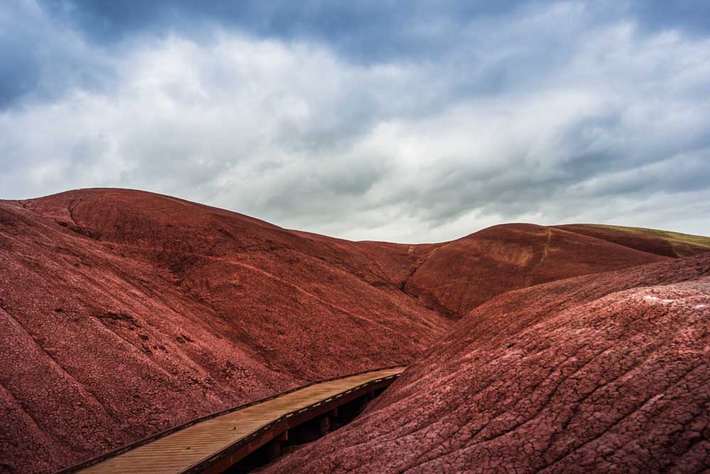
- The boardwalk trail and the red vibrant hills on the Painted Cove Trail.
The rains came hard to northern Central Oregon in April, turning the John Day Basin’s typically dusty and dry landscape into one that was lush green and soggy.
The John Day River, which twists through the basin, was swollen and muddy brown due to runoff from the hills beside it. Nonetheless, the adventure awaited. Following the river and its forks is one of the most complete paleontological sites on the planet for the mid-Cenozoic geologic era.
Created in 1975, the John Day Fossil Beds National Monument has provided paleontologists and geologists with mountains of evidence as to the origins of Oregon’s land, plants and animals. It has also given travelers some of the most striking and varied landscapes in the state.
There are no dinosaurs here — Oregon is too young for them. This is the age of mammals.
The monument is broken into three separate units, each one showing several earth-changing events of the past 54 million years, such as volcanic activity and climate change, and highlighting different collections of fossils, called assemblages, throughout that geologic history as well as some of the human history of the basin.
Geologically, it’s a relatively short period of time, and the monument allows visitors to realize this through interpretive trails, a paleontology center and offering the chance to see these geologic changes for themselves.
Each unit has a fantastical element to it, with semi-bulbous spires of blue-green rock or cosmic red dirt, seemingly pulled from the imagination of George Lucas.
Far out
The Clarno Unit may be the one unit of the monument that is most infrequently visited. It’s small compared to its paleontological siblings to the south and has three short walking trails.
Don’t discount it.
This is one of the oldest formations in the park and home of the Clarno Nut Beds and the Hancock Mammal Quarry.
The Nut Beds are a site rich in fossils from 44 million years ago showing evidence from Oregon’s semi-tropical past, including the presence of an early banana plant, flowering dogwood, crocodilelike creatures, magnolias and palms.
As the name suggests, the Mammal Quarry holds the evidence from 40 million years ago of the many mammals that roamed Oregon, including early three-toed horses, bearlike animals similar to modern pigs and brontotheres, a large animal similar to a rhino.
Today, the fossils and the Clarno Palisades are all that remain.
This fortresslike rock face was created from a massive lahar, a boiling hot ash mudslide that raced through the valley, petrifying a plethora of plants and animals in the area from 50 million years ago.
Erosion has left the reddish rocks towering above the valley floor topped with small spires.
The compelling landscape is juxtaposed with the rolling green, velvet hills of spring and the budding wildflowers like the red-stemmed prairie star and the yellow bell beginning to make an appearance.
During the scorching days of summer, the hills will mute to browns and tans with the sage dominating the sides of the trails.
The looping Trail of Fossils features several branch and leaf fossils in the boulders along the path, and the Clarno Arch trail leads 200 feet up the side of the cliff to the base of a small natural arch formed at the top of the Palisades.
The other trail aims to kinetically show how much time has passed since the lands here were formed. The Geologic Time Trail leads travelers on a quarter-mile flat path that represents 37,000 years for each foot of the path. Placards along with way mark key events in the geologic timeline, starting from the formation of the Palisades, to the first emergence of grasses 30 million years ago and to evidence of early human activity in the area 15,000 years ago.
Leaving the unit and driving towards the town of Kimberly, the landscape boasts more formations from other events throughout the geologic timeline, including the Columbia River Basalt flows formed 16.5 million years ago. The time frames are represented by stratified layers of rock protruding from the earth from buff-pink to blue-green in color of different shapes and combinations.
Cant, Condon and the Cove
Driving along the John Day Highway, the human effect on the landscape is evident and abundant.
Butted against the spectacular rock formations, which seem to come out of nowhere, are bright, emerald-green fields on the banks of the John Day River.
This is cattle country. Every pasture seems to be filled with brown and black bovines and rambunctious calves.
That wasn’t always so.
A brilliant white farmhouse sits in one of these vivid green fields surrounded by weathered barns and outbuildings, shadowed by ancient blue-green rocks.
Cant Ranch was once a successful sheep ranch run by Scottish settlers James and Elizabeth Cant from 1910 until their deaths in the early 1970s.
The Cants’ large sheep herd gave the monument’s unit and hill, just east of the ranch, their names — Sheep Rock.
The land was purchased by the National Park Service after the Cants died. The agency operated a visitor center and museum out of the ranch house until building the Thomas Condon Paleontology and Visitor Center in 2005.
The center is named for Thomas Condon, a minister who settled in The Dalles in 1861.
Condon was also an amateur geologist who would hold evening lectures and invite people to bring him rock specimens to add to his own collection.
In 1862, a group of soldiers returning from the John Day Basin brought Condon something that sparked his curiosity. Three years later, he traveled south with the U.S. Cavalry to explore the region the soldiers’ specimen came from.
When he did reach the area, he found a treasure trove of fossils and rocks from 25 to 35 million years ago, dubbing the area Turtle Cove, the most productive fossil-bearing layer in the monument.
News of his discoveries spread throughout the scientific community, and more and more geologists and paleontologists began exploring the basin in search of fossils.
Condon was later named Oregon’s first state geologist and went on to teach the subject at the University of Oregon until his death in 1907.
Three more geologic assemblages are represented heavily in the rocks here: the Upper John Day (24 to 20 million years ago), the Mascall (15 million years ago) and the Rattlesnake (seven million years ago). Each layer shows the cooling and drying climates as opposed to the semitropical seen in Clarno. Here, the first burrowing animals were followed by giraffe-deer, four-tusked elephant relatives and finally a collection that more closely resembles our own semiarid landscapes with short-faced bears and saber-toothed cats.
Some of the fossils collected here are on display at the paleontology center.
The fossils are paired with large, colorful and detailed murals of what each of the eight assemblages within the monument may have looked like from the animals to the trees.
Each section guides visitors through time.
A large window in the main hall of the center peeks into the lab, where on occasion diligent paleontologists can be seen grinding away dirt and stone from a newly uncovered fossil.
Sheep Rock is the largest unit within the monument and boasts several trails within its boundaries.
Cant Ranch has two short trails around the property highlighting both the historic property and Sheep Rock.
Blue Basin, located 5 miles north of the ranch, has two trails, one the longest in the monument. Both showcase the brilliant blue-green clay stones of the John Day Formation and are rich with fossils.
The Foree is five more miles from the trailhead at Blue Basin. Two short trails take travelers to two vistas that look otherworldly with rich blue-green rocks sprawled on cliffs on one trial and a lower grotto carved below the path on the other.
Life on Mars
Possibly the most photographed and widely recognized part of the monument is the Painted Hills Unit.
But these striking hills of red and yellow are more than a great backdrop for a selfie.
The hills here are made of paleosols, or ancient soils, with the colors marking the changing climate over the past 50 million years.
The brilliant reds in the hills come from an iron-rich environment indicating a wetter climate, the yellows come from a drier environment. It’s a diary of geologic history.
Walking through these gently rolling, richly colored hills conjures images of a Martian landscape and Edgar Rice Burroughs stories.
Signs are posted throughout the unit reminding visitors to stick to the trails. A campaign on the monument’s social media pages and website, #DontHurtTheDirt aims to discourage wandering off the designated paths.
It’s easy to see why they need these reminders. Footprints from stray travelers are embedded in the wet clay and can scar the cosmic landscape.
The Painted Hills Unit has five distinct trails within it, most under a half-mile each.
Perhaps the most famous is the Overlook. The trail on the ridge above the hills overlooks the hills striped with reds, yellows and flecks of black.
The colors can change depending on the time of day and the weather, with the rainy season boasting richer hues and sunrise and sunset providing a heavy contrast to the pigments.
Those wanting a wider look of the area can hike the Carroll Rim trail, a 1.6-mile hike up the 400-foot hill to the north of the overlook.
Also north of the overlook, a quarter-mile trail winds through the smaller hills of Painted Cove, giving travelers an up-close view of the brilliant spectrum of colors.
The soil looks cracked like a dry lakebed and the proximity to hills seem to yield their most vibrant tones.
Trail four is a loop around Leaf Hill, an extensively excavated hill that has yielded hundreds of leaf fossil specimens over the years from the Bridge Creek Formation (33 million years ago).
On the unit boundary is Red Scar Knoll, also known as Red Hill Trail. It’s a cone-shaped hill of bright yellow and red next to juniper trees singed by fire.
Oregon rocks
Oregon is young, geologically speaking.
Our oldest exposed rocks come from the Devonian period, 400 million years ago, whereas all other western states (except for Hawaii) contain rocks aged at least 1 billion years old.
The land that makes up Oregon was created from a series of volcanic arc islands that were eventually shoved up against the North American plate due to plate tectonics and a process known as accretion.
After that, a series of cataclysmic volcanic events here and around the Pacific Northwest from 48.4 to 7 million years ago built the stunning landscapes we see today.
Driving through the monument and the land surrounding the three units, the scenery changes from rolling hills to badlands topography to forests to valley lowlands and back again, exposing stunning rock features and faces along the way.
Within the 10,000 square miles of the Basin, John Day Fossil Beds showcases this incredible amount of geologic history like nowhere else in the world.
It’s not hard on the eyes either.
— Makenzie Whittle is a Bend native. She and her family have taken day trips since she was an infant, exploring the far-reaching corners of Oregon. She continues the tradition today, and can be reached at 541-383-0304 or mwhittle@bendbulletin.com


Best of the Best of Bend 2025

-
eEdition

-

-
Go! eEdition