Cascade Lakes make a dream staycation
Published 2:15 am Thursday, June 11, 2020
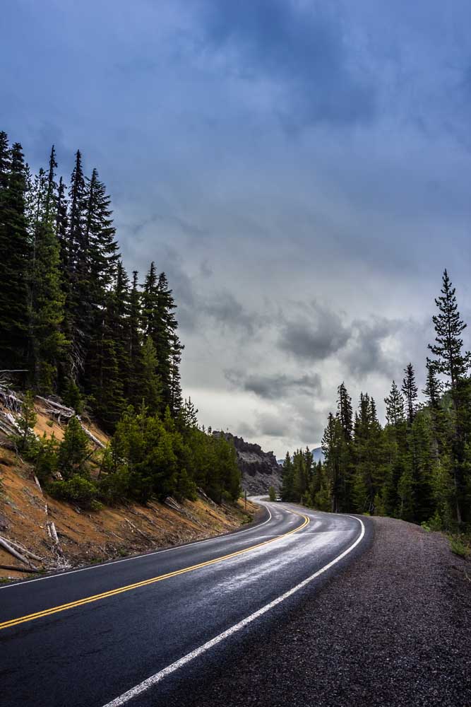
- Makenzie Whittle/The BulletinThe Cascade Lakes National Scenic Byway twists around an obsidian flow near Devils Lake as a rainstorm passes overhead.
While the Swiss Alps or Banff, Alberta, Canada, may be dream vacation destinations with their winding roads, snow-capped peaks and crisp mountain lakes and streams, the same feeling can be achieved by heading up the Cascade Lakes National Scenic Byway. Central Oregon’s historic road twists around lava flows, through meadows and forests with a variety of lakes sprinkled throughout with each highlighting a different recreation that locals and tourists love. The highway rises steadily through the Deschutes National Forest until suddenly, turning a corner when Mount Bachelor appears, larger than life, welcoming you to the Cascades. Famous in the winter for its skiing, snowboarding and tubing activities, the mountain closed down early this year due to the coronavirus, and though it had a limited opening earlier this spring, ski season has officially ended at the resort.
But don’t think that all opportunities have melted away, the mountain’s summer season is yet to kick off.
Trending
Offering mountain biking trails, chairlift rides to the summit, a disc golf course and a new zip line course, there is still plenty of fun to be had on the mountain.
There is a strenuous hike up to the summit for more adventurous travelers that offers a breathtaking view of the rest of the Central Oregon Cascades. On a clear day, you can see as far north as Mount Adams or as far south as Mount Shasta.
The road past Mount Bachelor is lined with lakes, acting as stopping places for recreation of all kinds and each with camping sites that have slowly begun to reopen.
Todd Lake to Hosmer Lake
The first lake along the byway is Todd Lake, a smaller water hole flanked by Mount Bachelor and Broken Top. A trail around the brilliant blue water goes straight through a meadow where in the early summer, hundreds of frogs can be found leaping from the water to land and back.
As of June 5, the road to the lake still had deep sections of snow and was not accessible by car.
Trending
The byway, too, continues to have snow, but it is relegated to the side and is quickly diminishing with longer days and better weather.
Through the coniferous forest, the road descends further into a lower valley. Turning another corner and South Sister rises out of the hills starkly just before the turn off to Sparks Lake.
This shallow lake spreads over 370 acres and is surrounded by another 360 acres of meadow. Thousands of years ago, the lake encompassed the entire area but has since shrunk, leaving the grassy meadows and cold creek channels behind.
Sparks Lake is popular for kayaking, canoeing and stand up paddleboarding as the max speed limit on the lake is 10-miles an hour. It also is a great spot for having a picnic along the gentle sloping bankside. While this isn’t the Swiss Alps where you may feast on sumptuous wines and cheeses, you can have the Central Oregon version of it, packing along your favorite IPA or cider to sip while you watch the clouds swirl over South Sister and Broken Top or birds dancing on the water.
Following the byway through probably the most photographed meadow in Central Oregon with a perfect view of Mount Bachelor and past a small lava field that formed from South Sister, lies the 23-acre Devils Lake alongside the road.
The turquoise water and an average depth of 3-feet make it ideal for paddling, fishing or walking the short trail around it to enjoy the views. Because of the size and shallowness, motorized boats are prohibited.
The road hugs the side of the lake and as such, there is no real turn off or parking area for it. Instead, there are three large pull-outs for a handful of vehicles to park.
The Devils Lake Trailhead lies just south of the lake and provides access to the Three Sisters Wilderness area for more strenuous backpacking trips or trails to lakes with no road access like Morane and Green lakes. Currently the trailhead is closed due to hazardous trees.
A 10-minute drive along the byway will lead you to Elk Lake, one of the most picturesque along the road with the Three Sisters to the north and Mt. Bachelor to the east.
The water is incredibly clear and cold, meaning that kokanee can thrive here, though only to 7- to 10-inches on average.
Wind on the lake can get pretty gusty come afternoon, which is when sailboats can be seen dotting the brilliant blue waters.
The Elk Lake Lodge and Marina has a small store and restaurant and full bar that offers sandwiches, salads, soups and more. Saturday’s during the summer you may even catch a local band playing with the lake as their backdrop.
Hosmer Lake is tucked away behind its larger neighbor. Popular with kayakers and fly-fishermen, the shallow greenish lake is split into two parts with a narrow channel of water connecting the two.
Because of its shallow depth, the lake’s large Atlantic salmon, brook and rainbow trout can be easily spotted, as well as hordes of mosquitos during the summer. Pack some repelant.
Lava Lake to Davis Lake
A five-minute drive from the turnoff to Hosmer is the duo of Lava Lake and Little Lava Lake, both featuring near-perfect views of the mountains.
The lakes are relatively old according to the USFS as evidenced by the vegetation growth and 4- 5-foot deep layer of muck along the Lava Lake lakebed.
A lava flow from Mt. Bachelor split the lakes into two and altered their drainage patterns. Both are surrounded by verdant forests, reed meadows and lava outcroppings making way for a variety of wildlife to call the lakes home.
Lava Lake (the big one) is home to a cozy resort and marina that is currently open and offers boat rentals, RV sites for rent and features a small store.
Little Lava Lake is only 130-acres in size, and while it has some good fishing (though not as good as it’s neighbor) that is not the biggest thing it has going for it. The small, relatively shallow lake is the headwaters of the Deschutes River.
From here the lakes get bigger and deeper.
Ten-miles from Lava Lake is the deepest lake along the byway, Cultus Lake. Shadowed by Cultus Mountain, a 6,700-foot forested butte, the lake is home to trophy-sized mackinaw as well as rainbow and brook trout.
Come the summer heat, the lake will be full of waterskiers and boaters taking advantage of the large, brilliant blue lake and the rustic cabins and scrumptious milkshakes at the Cultus Lake Resort.
Due south of Cultus Lake is another aptly named smaller neighbor called Little Cultus Lake.
The much quieter body has gently sloping shorelines to the maximum 60-foot depth in the center of the lake.
Surrounded by forest and featuring a primitive campground, the road to the lake is bumpy but worth it.
Almost directly across the byway Cultus Lake, is Crane Prairie Reservoir, famous for its “cranebows” (rainbow trout that have grown larger and more quickly due to the lake’s food supply) and one of the more interesting shorelines in the Cascade Lakes.
The Deschutes River was dammed here and the reservoir was created to store irrigation water for the Central Oregon Irrigation District. A part of the forest was flooded to make way for the relatively shallow lake leaving behind an abundance of snags and barkless trees still standing in the lake.
This makes it a great place to view wildlife including migratory birds who like to hang out on the branches and along the shoreline.
Not far downstream Wickiup Reservoir, also created to store irrigation water, but this time for the North Unit Irrigation District.
As with all reservoirs, the water level can drastically fluctuate throughout the year, currently, Crane Prairie is fairly full while Wickiup stands at 48% as of June 9 according to the Bureau of Reclamation website.
Named for the oval framed huts made of reeds and grasses used by the Native Americans who would camp here during the fall, Wickiup is known for its fishing and recreational opportunities like water skiing and windsurfing.
Finally, the Cascade Lakes National Scenic Byway ends with Davis Lake, one of the most popular fly fishing destinations in the Pacific Northwest and a productive wildlife area.
With a gorgeous meadow lining the east side of the lake, gentle sloping buttes to the west and a rocky lava flow to the north, the lake features rainbow trout and illegally introduces large mouth bass.
The quieter lake is also home to great grey owls, Rocky Mountain elk, bald eagles, osprey, pelicans and more migratory birds. In the nearby forested Hamner Butte threatened northern spotted owls have also been found.
The road officially ends at State Highway 58 near Crescent and Odell lakes near the towns of Gilchrist and Crescent making the entire loop back to Bend around 144 miles, but with scenery like that and each lake with at least one camping area so close to home, it makes the journey worth every mile.
Marketplace

Enter the $5,000 Sweepstakes

-
eEdition

-

-