Conditions report: Take a hike, camp in the woods
Published 12:00 am Friday, July 24, 2020
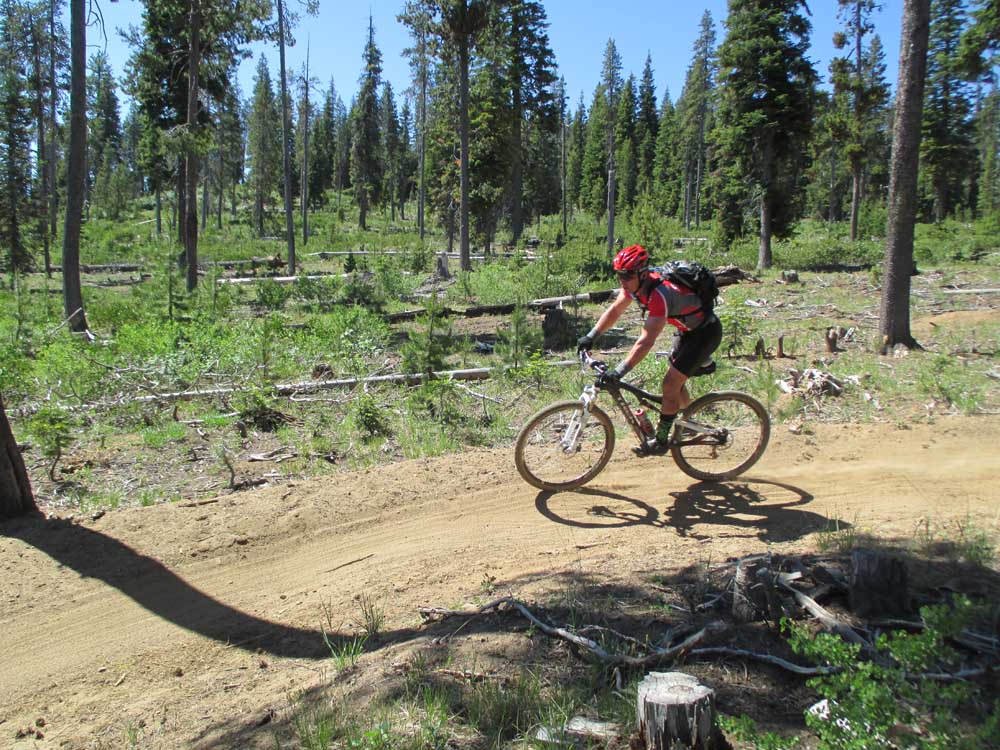
- A mountain biker turns along the Dinah-Moe-Humm Trail near Edison Sno-park southwest of Bend.
Cool off under the shade of ponderosa pines in one of Central Oregon’s many forests. The following hikes and campgrounds feature wooded areas currently open.
For a full list of conditions updated regularly, please visit centraloregonexplore.com
Hiking and Day Use Sites
Deschutes National Forest
Bear Valley Trailhead: Open
Bessie Butte Trail: Open
Black Butte Trailhead: Open
Black Crater Trailhead: Open
Buttes Loop Trailhead: Open
Canyon Creek Trailhead: Open
Chush Falls: Open; snow-free until last half-mile
Cold Springs Day Use: Open
Crater Butte Trailhead: Open
Crater Ditch Trailhead: Open
Devil’s Lake/South Sister Trailhead: Open; likely snow-free for the first mile, deep snow beyond on the trail up to South Sister
Dutchman Trailhead: Open; Tumalo Mountain is likely clear of snow
Edison Trailhead: Open
Green Lakes Trailhead: Open; trail is snow-free with patches in the basin, light deadfall, heavy deadfall from Pole Creek trail to Park Meadow Junction
Lava Cast Forest Trailhead: Open
Lower Black Butte Trailhead: Open
Lower Canyon Creek (West Metolius Trailhead): Open
Meissner Trailhead: Open
Mile Camp Day Use: Open
Millican Trail Trailhead: Open; clear as far as Trout Creek Tie with heavy deadfall reported beyond
Pacific Crest Trail: Moderate blowdown throughout with deep snow on higher elevations
Park Meadow: Open; clear from the trailhead to 1/4-mile west of Whychus Creek
Phil’s Trailhead: Open
Pine Mountain: Open
Pole Creek Trailhead: Open
Rimrock Trailhead: Open
Scott Pass Trailhead: Open
Sisters Tie Trailhead: Open
Skyliners Trailhead: Open
Sparks Lake Trailhead: Open; likely snow-free with light deadfall
Swampy Lakes Trail: Open
Tam McArthur Rim Trailhead: Likely snow-free
Ten Mile Trailhead: Open
Tandy Bay Picnic Area: Open
Todd Creek Trailhead: Open; likely snow-free
Wake Butte Trailhead: Open
Wanoga Trailhead: Open
Whychus Creek Overlook Trailhead: Open
Whychus Portal (Lower Whychus Trailhead): Open
Wickiup Plains Trailhead: Open
Ochoco National Forest
Baneberry Trailhead: Open
Barnhouse Trailhead: Open
Black Canyon West (Formerly Dusty Camp) Trailhead: Open
Coffeepot Trailhead: Open
Cottonwood Trailhead: Open
Cougar West Trailhead: Open
Fry Trailhead: Open
Giddy-Up Go Trailhead: Open
Green Mountain North Trailhead: Open
Green Mountain South Trailhead: Open
Hammer Creek Trailhead: Open
Keeton Trailhead: Open
Line Butte East (Formerly Fawn Creek) Trailhead: Open
Line Butte West Trailhead: Open
Lookout Mountain Lower Trailhead: Open
Lookout Mountain Upper Trailhead: Open
Mother Lode Mine Trailhead: Open
Payten Trailhead: Open
Potlid North Trailhead: Open
Potlid South Trailhead: Open
Rock Creek Trailhead: Open
Round Mountain North Trailhead: Open
Round Mountain South Trailhead: Open
Steins Pillar Trailhead: Open
Walton Lake Trailhead: Open
Wildcat South Trailhead: Open
Bend Park & Recreation Trails
Coyner Trail: Open maintain social distancing
Deschutes River Trail — Awbrey Reach: Open; maintain social distancing
Deschutes River Trail — Old Mill Reach: Open; maintain social distancing
Deschutes River Trail — Pioneer Reach: Open; maintain social distancing
Deschutes River Trail — River Run Reach: Open; maintain social distancing
Deschutes River Trail — South Canyon Reach: Open; one-way trail, closed to bikes, keep dogs leashed, maintain social distancing
Pine Nursery Park Trail: Open; maintain social distancing
Riley Ranch Nature Reserve Trails: Open; maintain social distancing
Sawyer Park Trails: Open; maintain social distancing
Shevlin Park Trails: Open; maintain social distancing
Oregon State Parks
La Pine State Park: Open; reduced services
Tumalo State Park: Open; reduced services
Camping
Note — annual campfire restrictions are now in place on portions of the Deschutes, John Day, White and Crooked rivers as well as BLM land along Lake Billy Chinook. See centraloregonfire.org for more details.
Deschutes National Forest
China Hat Campground: Open
Cold Springs Campground: Open; no water
Crescent Creek Campground: Open; no water
Graham Corral Horse Camp: Open
Pine Mountain Campground: Open; no campfires
Quinn Meadow Horse Camp: Open
Sisters Cow Camp Horse Camp: Open
Soda Creek Campground: Open; no water, no campfires
Ochoco National Forest and Crooked River National Grassland
Allen Creek Horse Camp: Open
Barnhouse Campground: Open
Cottonwood Campground: Open
Cottonwood Pit Campground: Open
Elkhorn Campground: Campground: Open
Mud Springs Horse Camp: Open
Ochoco Divide Campground: Open
Whistler Campground: Open
Wildcat Campground and Day Use Area: Open
Cycling
East of Bend trails
Arnold Ice Cave: Sandy and loose
Dry River Canyon: Closed to protect nesting raptors
Horse Butte Loop: Sandy and loose
All other trails riding well
Phil’s Trail Complex
Expressway, Marvin’s Garden, Ticket to Ride (North and South) and Upper Storm King: Sandy and loose
C.O.D., Phil’s and Upper Whoops are riding well with deadfall reported
All other trails are riding well
Wanoga Trail Complex
Duodenum: Riding well with deadfall reported
Dinah Moe Humm, Tiddlywinks and Tyler’s Traverse: Sandy and loose
All other trails are riding well
North of Skyliner trails
Lower and Upper Mrazek: Sandy and loose
All other trails are riding well
Swampy Lakes trails
Lower Flagline, S.S.T., Sector 16, Swampy Lakes Loop, Swampy-Dutchman, Tumalo Ridge and Upper Flagline: Sandy and loose
Middle Flagline: Closed until Aug. 15 to protect elk habitat
All other trails are riding well
Cascade Lakes trails
Edison-Lava: Sandy and loose
Metolius-Windigo (Todd Lake): Riding well
Metolius-Windigo (Lava Lake): Riding well; deadfall reported
Mt. Bachelor
Last Chance and Redline need new reports
All other trails are riding well
Sunriver area trails
Black Rock: Sandy and Loose
Crater Rim, Elko Point and La Pine State Park: Riding well; deadfall reported
All other trails riding well
Prineville and Ochoco trails
66 Trails and Cougar Creek: Riding well; deadfall reported
All other trails riding well
Sisters trails
Green Ridge and Metolius-Windigo (Black Butte): Riding well; deadfall reported
Metolius-Windigo (99) and Peterson Ridge Tie: Sandy and loose
All trails riding well
Maston complex
All trails reporting sandy and loose conditions
Redmond trails
Dry Canyon: Riding well; deadfall reported
All other trails riding well
Fishing
Updated at 8 a.m. July 23.
Crane Prairie Reservoir: 80% full; brook trout, kokanee, largemouth bass, rainbow trout; fishing is good for “cranebows” and fair for bass, algae bloom throughout the lake but heaviest by the dam.
Wickiup Reservoir: 25% full; kokanee, rainbow and brown trout, largemouth bass and catfish
East Lake: Brown trout, kokanee, rainbow trout, Atlantic salmon; Fishing is fair with still-fishing, trolling, fly fishing, jigging and casting being the best methods.
Paulina Lake: Kokanee, rainbow and brown trout; fishing is fair for kokanee and browns. Recommended still-fishing, trolling, fly fishing and jigging.
Ochoco Reservoir: 32% full; rainbow trout, black crappie, smallmouth bass; fishing is fair to good
North Twin Lake: Rainbow trout; fishing is fair on powerbait, crawlers and trolled flies
South Twin Lake: Rainbow trout; fishing is fair on powerbait, crawlers, lures and flies
Davis Lake: Water level is low; rainbow trout and largemouth bass. Fly fishing only
Lava Lake: Rainbow trout; Still and fly fishing with casting lures toward the bank; fishing is good. Algae bloom.
Little Lava Lake: Rainbow trout, brook trout and whitefish; bait, lures and flies are best with still-fishing or trolled
Cultus Lake: Mackinaw, rainbow and brook trout; troll the depths for mackinaw and shallows for rainbow
Hosmer Lake: Brook, cutthroat and rainbow trout; fly fishing only
Elk Lake: Brook trout and kokanee; jigging, still-fishing and trolling from a boat or fly fishing are best
Crescent Lake: 47% full; kokanee, mackinaw, rainbow and brown trout, whitefish and chub; fair to good fishing for rainbow trout and kokanee
Odell Lake: Recreational use advisory in effect due to a harmful algae bloom
All raptor closure have been lifted.
Fire use restrictions are in place for lands administered by the Bureau of Land Management, the Deschutes National Forest and the Ochoco National Forest and the Crooked River National Grassland.
All open fires, wood stoves and charcoal briquette fires are prohibited except in the certain designated campgrounds. See the full list on centraloregonfire.org or in the full conditions report available online at centraloregonexplore.com
The restriction does not apply to wilderness areas in the Deschutes National Forest.
As of July 14, a level 2 Industrial Fire Precaution Level or Partial Hoot Owl has been issued meaning the use of power saws for personal or commercial cutting operations may only happen between 8 p.m. and 1 p.m.
As of July 22, Deschutes River access is closed due to safety concerns and to prevent further erosion to the river bank. The access point will be closed until further notice. For more information visit bendparksandrec.org


Best of the Best of Bend 2025

-
-
-