Conditions report for camping, trails, fishing at Central Oregon rivers, creeks
Published 2:00 am Friday, July 31, 2020
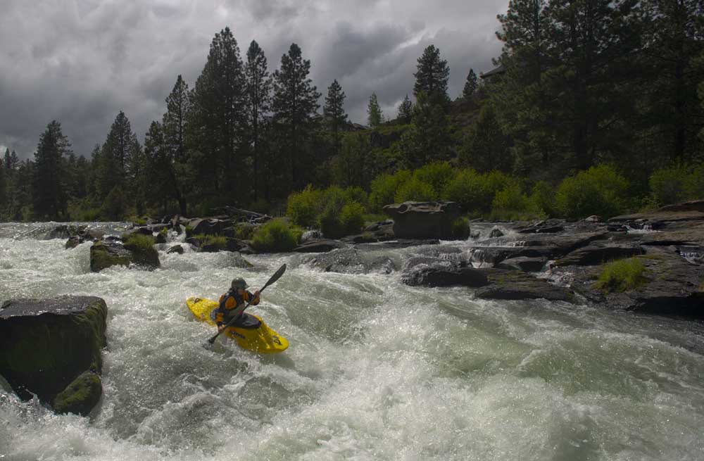
- RYAN BRENNECKE/THE BULLETIN FILE PHOTOA kayaker on the Deschutes River.
Cool off in a mountain creek or in one of Central Oregon’s beautiful rivers this weekend. Drop a line and see what bites or find a couple of trees to span your hammock between and let the gentle rush of the water relax your day away. Here are open trailheads and campsites near rivers and creeks, as well as current fishing conditions on them.
For a full list of conditions updated regularly, please visit centraloregonexplore.com
Hiking and Day Use Sites
Deschutes National Forest
Aspen Day Use: Open
Benham East Trailhead: Open; deadfall reported
Benham West Trailhead: Open
Besson Day Use: Open
Big Eddy Day Use: Open
Broken Top Trailhead: Open; access road is only recommended for high clearance and 4X4 vehicles
Canyon Creek Trailhead: Open
Chush Falls: Open
Cold Springs Day Use: Open
Devil’s Lake/South Sister Trailhead: Open
Dillon Day Use: Open
Fall River Headwaters: Open
Green Lakes Trailhead: Open
Head of Jack Creek Trailhead: Open
Head of the Metolius: Open
Lake Creek Trail: Open
Lava Island Day Use: Open
Lower Bridge Day Use: Open:
Lower Canyon Creek (West Metolius Trailhead): Open
Meadow Picnic: Open
Mile Camp Day Use: Open
Pacific Crest Trail: Moderate blowdown throughout with deep snow on higher elevations
Park Meadow: Open
Paulina Falls Picnic and Trailhead: Open
Pole Creek Trailhead: Open
Quinn River Day Use: Open
Rimrock Trailhead: Open
Slough Day Use: Open
Swampy Lakes Trail: Open
Ten Mile Trailhead: Open
Todd Creek Horse Camp: Open; likely snow free
Tumalo Falls Trailhead: Open
Whychus Creek Overlook Trailhead: Open
Whychus Portal (Lower Whychus Trailhead): Open
Ochoco National Forest
Black Canyon East (Formerly South Fork) Trailhead: Open
Black Canyon West (Formerly Dusty Camp) Trailhead: Open
Boeing Field Trailhead: Open
Cottonwood Trailhead: Open
Cougar East Trailhead: Open
Cougar West Trailhead: Open
Fry Trailhead: Open
Hammer Creek Trailhead: Open
Keeton Trailhead: Open
Line Butte East (Formerly Fawn Creek) Trailhead: Open
Line Butte West Trailhead: Open
Mascall Corral (Formerly Apple West) Trailhead: Open
Potlid North Trailhead: Open
Potlid South Trailhead: Open
Rock Creek Trailhead: Open
Scotty Creek Trailhead: Open
South Prong Trailhead: Open
Twin Pillars North Trailhead: Open
Twin Pillars South Trailhead: Open
Wildcat North Trailhead: Open
Wildcat South Trailhead: Open
Bend Park & Recreation Trails
Central Oregon Historic Canal Trail: Open; maintain social distancing
Deschutes River Trail — Awbrey Reach: Open; maintain social distancing
Deschutes River Trail — Old Mill Reach: Open; maintain social distancing
Deschutes River Trail — Pioneer Reach: Open; maintain social distancing
Deschutes River Trail — River Run Reach: Open; maintain social distancing
Deschutes River Trail — South Canyon Reach: Open; one way trail, closed to bikes, keep dogs leashed, maintain social distancing
Riley Ranch Nature Reserve Trails: Open; maintain social distancing
Sawyer Park Trails: Open; maintain social distancing
Shevlin Park Trails: Open; maintain social distancing
Oregon State Parks
Cline Falls State Scenic Viewpoint: Open; limited services; restrooms open 10 a.m.-7 p.m. daily and may close without notice
La Pine State Park: Open; reduced services; meeting hall and deluxe cabins are closed
Peter Skene Ogden State Scenic Viewpoint: Open
Smith Rock State Park: Open — limited services; no camping.
Tumalo State Park: Open; reduced services; showers open with reduced hours; yurts and group facilities are closed; day-use open 7:30 a.m.-7 p.m.
Camping
Note — annual campfire restrictions are now in place on portions of the Deschutes, John Day, White and Crooked Rivers as well as BLM land at Lake Billy Chinook. See centraloregonfire.org for more details.
Deschutes National Forest
Allen Springs Campground: Open; no water
Allingham Campground: Open
Camp Sherman Campground: Open
Candle Creek Campground: Open; no water
Cold Springs Campground: Open; no water
Crescent Creek Campground: Open; no water
Crescent Lake Campground: Open; water coming soon
Fall River Guard Station: Open; reservation only
Gorge Campground: Open; no water
Indian Ford Campground: Open; no water
Jack Creek Campground: Open; no water
Link Creek Campground: Open
Lower Bridge Campground: Open; water coming soon
Lower Canyon Creek Campground: Open; no water
McKay Crossing Campground: Open
Monty Campground: Open; no campfires
Ogden Group Campground: Open; no water
Pine Rest Campground: Open; no water
Pioneer Ford Campground: Open; water coming soon
Prairie Campground: Open
Riverside Campground: Open; no water
Smiling River Campground: Open
Soda Creek Campground: Open; no water, no campfires
Trapper Creek Campground: Open
Ochoco National Forest and Crooked River National Grassland
Allen Creek Horse Camp: Open
Big Spring Campground: Open
Biggs Springs Campground: Open
Cottonwood Campground: Open
Deep Creek Campground: Open
Elkhorn Campground: Campground: Open
Mud Springs Horse Camp: Open
Sugar Creek Campground and Day Use Area: Open
Whistler Campground: Open
Wildcat Campground and Day Use Area: Open
Wolf Creek Campground: Open
Wolf Creek Industrial Campground: Open
BLM — Prineville District
Big Bend Campground: Open
Castle Rock Campground: Open
Chimney Rock Campground: Open
Cobble Rock Campground: Open
Lone Pine Campground: Open
Macks Canyon Recreation Site: Open
Palisades Campground: Open;
Post Pile Campground: Open
Steelhead Falls: Open, no potable water
Stillwater Campground: Open
Cycling
East of Bend trails
Arnold Ice Cave, Boyd Cave Trail and Horse Butte Loop: Sandy and loose
Dry River Canyon: Closed to protect nesting raptors
All other trails riding well
Phil’s Trail Complex
Expressway, Lower Whoops, Marvin’s Garden, Ticket to Ride (North and South) and Upper Storm King: Sandy and loose
C.O.D. and Phil’s: Riding well with deadfall reported
All other trails are riding well
Wanoga Trail Complex
Duodenum: Riding well with deadfall reported
Dinah Moe Humm and Tiddlywinks: Sandy and loose
All other trails are riding well
North of Skyliner trails
Farewell, Lower Mrazek and Upper Mrazek: Sandy and loose
All other trails are riding well
Swampy Lakes trails
Lower Flagline, S.S.T., Sector 16, Swampy Lakes Loop, Swampy-Dutchman, Tumalo Ridge and Upper Flagline: Sandy and loose
Middle Flagline: Closed until Aug. 15 to protect elk habitat
All other trails are riding well
Cascade Lakes trails
Edison-Lava: Sandy and loose
Metolius-Windigo (Todd Lake): Riding well
Metolius-Windigo (Lava Lake): Riding well; deadfall reported
Mt. Bachelor
Last Chance needs new report
All other trails are riding well
Sunriver area trails
Black Rock: Sandy and Loose
Crater Rim, Elko Point and La Pine State Park: Riding well; deadfall reported
All other trails riding well
Prineville and Ochoco trails
66 Trails and Cougar Creek: Riding well; deadfall reported
All other trails riding well
Sisters trails
Green Ridge and Metolius-Windigo (Black Butte): Riding well; deadfall reported
Metolius-Windigo (99) and Peterson Ridge Tie: Sandy and loose
All trails riding well
Maston complex
All trails reporting sandy and loose conditions
Redmond trails
Dry Canyon: Riding well; deadfall reported
All other trails riding well
Fishing
Updated at 9 a.m. July 30.
Lower Deschutes (Pelton Dam to Columbia River): 4,170 cfs; rainbow trout, steelhead; current hatches — blue winged olive, midge, skwala, march brown, sulpin
Middle Deschutes (Benham Falls to Lake Billy Chinook): 3,670 cfs; brown trout, rainbow trout; current hatches — blue winged olive, midge, pale morning dun, sulpin, baitfish; Water and access conditions are good, no bait allowed, fishing for brown and rainbow trout on rapalas and spinners.
Upper Deschutes at Benham Falls: 1,644 cfs; brook trout, brown trout, rainbow trout; fishing is fair to good on flies and lures, no bait allowed
Crooked River (below Opal Springs): 1,262 cfs; rainbow trout and mountain whitefish; fishing is fair for rainbows, no bait allowed
Fall River: No flow data available; brook trout, brown trout, rainbow trout; fly fishing only; long leaders and 6-7x tippet and mid-day fishing is recommended
Metolius River: 1,360 cfs; bull trout, rainbow trout; fly fishing and catch and release only; fishing has been fair
Tumalo Creek: 14.9 cfs; rainbow trout
McKenzie River (at Clear Lake): 244 cfs
McKenzie River (near Belknap Springs): 719 cfs; rainbow and coastal cutthroat trout; current hatches — blue winged olive, midge, sculpin
All raptor closure have been lifted.
Fire danger is currently listed as Extreme in both the Deschutes National Forest and Ochoco National Forest.
Fire use restrictions are in place for lands administered by the Bureau of Land Management, the Deschutes National Forest and the Ochoco National Forest and the Crooked River National Grassland.
All open fires, wood stoves and charcoal briquette fires are prohibited except in the certain designated campgrounds. See the full list on centraloregonfire.org or in the full conditions report available online at centraloregonexplore.com
As of July 23, a level 3 Industrial Fire Precaution Level or Partial Shutdown has been issued meaning the use of power saws for personal or commercial cutting operations is prohibited until conditions change
As of July 22, Deschutes River access is closed due to safety concerns and to prevent further erosion to the river bank. The access point will be closed until further notice. For more information visit bendparksandrec.org


Best of the Best of Bend 2025

-
-
-